
|
|
Mountain/Rock |
|---|---|
|
|
42.31572°S / 173.60622°E |
|
|
Hiking |
|
|
Spring, Summer, Fall, Winter |
|
|
5256 ft / 1602 m |
|
|
Overview
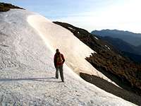
Going to Kaikoura? This is such a worthwhile peak to bag.Mount Fyffe forms part of the Seaward Kaikoura Range which was formed initially during the Miocene epoch, the Kaikoura ranges are composed primarily of greywacke and argillite.
A bit of history?... In 1843 Captain Robert Fyfe, reputed to be Kaikoura's earliest European settler, established "Waiopuka", the first shore whaling station near where his house, built in 1860, still stands on it's whale bone piles. Other whaling stations soon followed at South Bay but after 1850 whale numbers steadily declined and the exploitation of them became uneconomic. Today all marine mammals are protected in New Zealand and the whales are hunted with cameras instead of harpoons. Sheep and goats were introduced to the area by him in 1849 and in 1854 he was joined by his cousin George who leased an area north of Kaikoura known as the "Mount Fyffe Run" thus Mount Fyffe got it's name and farming began in the district.

If you have the time (8hrs) i think this, along with swimming with Dolphins, is one of the best thing you can do. Sitting in the Hot-tub at Dusky Lodge afterwards is also right up there (see pic).

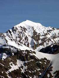
The Peak of Manakau - the highest peak on the Seaward Kaikoura Range - is clearly visible and, we thought, within reach if you pack an extra nights kit/food and some crampons and basic piolet.
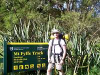
Getting There
Kaikoura is reached by Highway 1, which runs the length of the East coast of New Zealands beautiful South Island. From Blenheim, head south on H1, or from Christchurch head north on H1. If you are on the north west coast use the Lewis Pass from Murchison or Reefton.Once at Kaikoura a local map (or friendly local) will guide you to the car park at the start of the path to the summit. The trip from the town to the car park takes about 20 mins. From there it is suggested that it takes four hours to summit. However this is dependant on your pace - we found it took less time. There is a well trod path all the way up - so route finding is simple. But just in case...
See External Link 2 (below) for a detailed description on how to get to the car park and the summit.
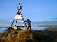
On arrival at the summit views of Banks Peninsula, kaikoura peninsula to the south and the North Island can be seen as a reward on a clear day.
There is a great ridge walk along the ridge (North East), you can leave your stuff at summit and it takes about two hours return.
The entire trip can be broken by spending a night at the Mount Fyffe hut.
There are ample supmarkets, pubs, and amenities at Kaikoura.
Red Tape
As far as i am aware no red tape exists.Camping
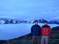
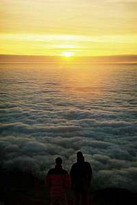
We camped on the summit (See pics) which gave us an amazing cloud inversion and stunning sunrise. I think there is camping near the Mount Fyffe hut but there are several flat spots on the summit itself.

External Links
Link 1 'http://www.kaikoura.co.nz/' - is a general tourist information site.Link 2 'http://www.virtual-kaikoura.com/activities/walkways/mountfyffe.htm' - a great description of how to get to the car park and the route up.