
-
 12297 Hits
-
 81.68% Score
-
 14 Votes
|
|
Area/Range |
|---|---|
|
|
46.29382°N / 9.70093°E |
|
|
Mountaineering |
|
|
Summer |
|
|
10994 ft / 3351 m |
|
|
Overview
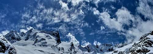
 Pano from Val Torrone.
Pizzi Torrone are the eastern section of Val Masino region, situated on the boarder between Italy and Swiss.
They look granite spires,typical of this area, probably the most impressive if seen from the south.
This group is composed by 3 main summits,named with the omonimous name "Torrone", and 6 secondary peaks(only in geografically sense).
 The north side.Photo taken from BERGFOTO's
From west:
-Picco Luigi Amedeo
-Pizzo Torrone occidentale(west) 3351m
-Punta Alessandra 3250m
-Punta Melzi 3258m
-Punta Ferrario
-Quota 2951
-Pizzo Torrone centrale(middle) 3290m
-Ago di Cleopatra 3230m
-Pizzo Torrone orientale(east) 3333m
On the south side thase summit are enclose into the Val Torrone, very steepy and wild pastures, reachable by a path not always easy to find.
Instead, the north flank is icey and colder, and with Punta Rasica and Monte Sissone, they form a wall of rock/ice ,which is the head of Forno glacier.
Those mountains, as the rest of the area, offer many solution for climbing routes.
In this page will be related only the overviews and main paths.
 North side of Pizzi Torrone.
Getting there
The best basecamp for those mountain are the refuge "Forno" from north and the bivouac Manzi/Pirotta from south.There is a new bivouac called "Mika" placed on the top of the morraine below the Monte Pioda in Val Cameraccio, but quite afar.
It could be useful only if someone want to reach the east flank of Torrone Orientale.
From Italy:
To get there you must drive along the SS38 starting from Milano or from Sondrio.
Just few km before Sondrio (coming from Milan), on the right side (N) of Adda river, the small town of Ardenno is the starting point for the road 404 that leads to S.Martino Val Masino.
Once in S.Martino follow the road on the right(East - Val di Mello)and try to find a car parking site (best one is near the Baita del Gigiat.
Here you must start walking following the marks for Manzi-Pirotta bivouac (2510m - about 4/5 hours walk - 1500m difference in elevation): this is the best starting point for all the climbs in this area.
As you can check on the related page, this bivouac is placed on the Sentiero Roma, and many people use to come here for a stage, from west(refuge Allievi - 2/3 hours), or from east (bivouac Kima - 3/4 hours).
From Swiss:
The Forno glacier and the related vallye, starts from Maloya pass. One can take a train to St. Moritz, then go by bus to Maloja Pass.
There are two main highways leading to St. Moritz: From the north and west via Chur and the Julier Pass,from the east via Innsbruck(or Bozen), Landeck, Zernez and from the south from Chiavenna.
From Maloya Pass a trail heads to the Forno Valley. The right hand fork leads up the well marked and fairly flat Forno Glacier.
On the moraine at leftside of the glacier lies the Forno Hut.(About 3/4 hours from Maloja Pass).
Picco "Luigi Amedeo"
 Picco Luigi Amedeo
The Picco Luigi Amedeo where is the most difficult (ED) and frequented route of this small area: the "Taldo-Nusdeo", another important route on this summit is the SSW edge (Bonatti TD-)
It's the first and major summit when seen comin' up from Val di Mello.
Routes:
NNE Ridge (III°)
SE Wall (Nusdeo,Taldo 01/06/1959)(V°/V°+ A2/A3)
SSW Edge (Bignami,Bonatti 07/06/1953)(IV°/V° A1)
Pizzo Torrone occidentale (west) 3351m
 Torrone Occidentale.
This is the higher and main summit. The south spur begin on the Torrone pass with Picco Luigi Amedeo as head, and seeing from south,the real summit is difficult to recognize.
The photo show the south-west spur,seen from Val di Zocca.
Routes:
SE Wall (Compagnoni,Meroni 05/07/1959)(V°/V°+)
SE Wall (Via Bramani 26/07/1936)(V°)
SW Edge (E.F.Cugiatti 13/07/1974)(V°/VI° A1/A2)
N Wall (Freymann,Wyss 17/08/1931)(IV°)
Punta Alessandra 3250m
This secondary peak is situated on the ridge between the Pizzi Torrone west and middle. It's visible only from north.Routes:
ESE-WSW Ridge (Rydzewsky,Eggerberger,Klucker 09/07/1899)(III°+)
Punta Melzi 3258m
It's a pinnacle part of the south spur of Torrone centrale(middle). Clearly a secondary summit.Routes:
WSW Ridge (Corti,Olivo,Lenatti 08/1938)(III°/IV°)
Punta Ferrario
 Punta Ferrario
The Punta Ferrario,head of south spur of Torrone centrale. Very impressive if seen from the bivouac Manzi.
On its south wall a very difficult route (450m drop)
Routes:
ESE Wall (Bernasconi,Bignami,Meroni 20/07/1952)(IV°/V°)
S Wall (Aiazzi,Pizzocolo,Taldo 25/07/1063)(IV°/V°+)
SSW Wall (Frisia,Taldo,Zamboni 04/10/1959)(VI°+ A2)
W Wall (Bignami,Meroni 09/09/1956)(IV°/V°-)
Quota 2951
On the S edge a fine difficult (TD) route (Mauri-Ratti)Pizzo Torrone centrale (middle) 3290m
 Torrone Centrale
Probably the less interesting. The real summit stay hidden from south. In the photo,it's visible un the right side.
Punta Melzi is one of the pinnacles,between the Ferrario(left) and Torrone centrale.
Routes:
NNE Edge (Frei,Margadant 27/08/1933)(IV°/V°)
E Wall (Corti,Lenatti 17/08/1934)(III°/IV°)
SE Ridge (Zucker,Risch 25/07/1923)(III°)
SSW Wall (Bignami,Maccagno,Malinverno 08/1932)(III°)
Ago di Cleopatra 3230m
Huge monolith tall 40 meters.Nice and caracteristic.Pizzo Torrone orientale (east) 3333m
 Torrone Orientale
Beautiful and impressive peak. Brobably the most amongs those. Admired also from Val Cameraccio.
The Ago di Cleopatra is the pinnacle on the left of the summit. On the S ridge of the Pizzo Torrone Orientale 2 very fine routes.
Routes:
S Ridge-SE/SW Wall (Steger route)(400m D+)
S Ridge (Osio,Canali 18/08/1952)(TD inf - long and various)
ENE Ridge (Bonacossa,Ratti 25/09/1948)(III°/IV°)
SE Wall (Taldo,Zamboni 28/08/1966)(V°+)
S Ridge (Bonacossa,Pietrasanta 01/09/1932)(III°/IV°)
Refuges
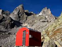 bivouac Manzi-Pirotta
Bivouac
Area: Val Torrone (Val di Mello)
Altitude: 2540m
Route: From S.Martino in Val Masino 923m
Time: 5-6 hours
Difficulty:
Owner: C.A.A.I. (Club Alpino Accademico Italiano)
Keeper: None
Places: 9
Climbs: Pizzi Torrone
Excursions:
-Sentiero Roma
-Refuge Allievi across "Passo del Torrone" 2518m (EE 2 hours)
-Refuge Ponti across "Passo Cameraccio" and "Bocchetta Roma" (EE 3/4 hours)
 refuge Forno
Refuge
Area: Valle del Forno
Altitude: 2574m
Route: From road to Maloja Pass 1790
Time: 3 hours
Difficulty:
Owner: CAS Sez. Rorschach
Keeper: Fam. Brunner
Refuge telephone: +41-818243182
Places: 102
Winter room places: 30
Climbs and excursions: Monte del Forno, Cima di Rosso, Monte Sissone
Email: None
Gabriele Roth - Oct 16, 2006 6:11 am - Voted 10/10
some more infothese mountains are named : Pizzi Torrone (not Pizzi del Torrone) Two important summit are missing : the Picco Luigi Amedeo where is the most difficult (ED) and frequented route of this small area : the Taldo-Nusdeo, another important route on this summit is the SSW edge (Bonatti) (TD inf) the "quota 2951" - on whose S edge a fine difficult (TD) route (Mauri-Ratti) Punta Alessandra and Punta Melzi are "minor" and low important summits On the S ridge of the Pizzo Torrone Orientale 2 very fine routes : S ridge and SE-SW wall - Steger route (D sup - 400m) S ridge : Canali-Osio - a classic route (TD inf - long and various)