
|
|
Mountain/Rock |
|---|---|
|
|
56.23853°N / 4.81716°W |
|
|
Hiking, Mountaineering |
|
|
Spring, Summer, Fall, Winter |
|
|
3317 ft / 1011 m |
|
|
Overview
Beinn Ime (translation: Butter Hill) is located just north of the famous Arrochar summit of The Cobbler and is No.118 in the Scottish Munros table. Sitting at a height of 1011m/3317ft it is the highest of all the peaks in the Cowal & The Arrochar Alps District. There are two tops with the highest being the one at the northwest end of the summit ridge. This is clearly marked by the large circular cairn that provides excellent shelter in fouler weather. The east, west and northern sides of the mountain are fairly rugged, and for this, reason most ascents are done via the easier southern side that is broad and grassy.
As stated, Beinn Ime is best approched from Arrochar in the south, where most people usually do it in conjunction with either The Cobbler or Beinn Narnain or even both. It is possible to approach from the east at Inveruglas also, where a three peak circuit of Ben Vane, Ime and Beinn Narnain can be done.
Rock climbing on Beinn Ime can be found on the east face and is concentrated on Fan Gully Buttress, which is roughly 120m high. Most notable routes on this section are; Ben's Fault, 120m, Airy Ridge, 100m and Buttress Route, 120m. Winter climbing routes available include; Fan Gully, 100m, Hanging Groove, 170m and Forked Gully, 150m. The winter climbing routes vary from Grade II to Grade IV.


Getting There
The best city in Scotland for Beinn Ime is Glasgow, however access can be gained from a variety of locations. Beinn Ime is best climbed from Arrochar in the south, but can also be climbed from Glen Kinglass in the west.
Airports
There are a variety of airports throughout Scotland that would provide easy access to Beinn Ime. Below are a selection of the homepages for these airports;
Glasgow Airport
Edinburgh Airport
Prestwick International Airport
Car
View Larger Map
Train
Glasgow Queen Street station direct to Arrochar.
Scotrail info
Bus
Buses run daily from Buchanan Street bus station in Glasgow to Arrochar.
Scottish City Link info
Red Tape
There is no red tape in Scotland due to the Land Reform (Scotland) Act 2003 which incorporated the Scottish Outdoor Access Code. This code, which commenced on the 9th of February 2005, has established statutory rights of access to land and inland water for outdoor recreation.
The Land Reform(Scotland) Act 2003
Scottish Outdoor Access Code
The following aspects should be taken into consideration when you are in the Scottish countryside;
- Seek local advice in regard to deer stalking or grouse shooting activities
- Ensure that all gates are closed behind you
- During the lambing season (March to May) ensure that all dogs are kept on a lead
- Please refrain from feeding or annoying any animals
- Limited parking space is available at the start of many routes, please ensure that you are not blocking a road and/or entrance
- Parking is provided at the start of some routes by the local farmers, it is polite to ask if you can use this facility
- Try to refrain from crossing fields with animals and/or crops if an alternative route is available
- Ensure that you treat the local environment with care by leaving it as you found it and by taking any litter home with you
- Any camp fires should be carefully watched and only used away from dense forest areas
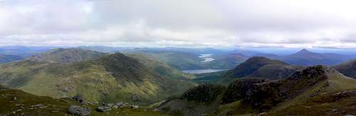 Eastern view from Beinn Ime's summit.
Accommodation
Below is a list of possible accommodation venues that are located in the direct vacinity of Beinn Ime.
Hotels/B&B's
Tarbet hotel
Colquhoun Arms Hotel
Rowantree Cottage
Ardlui Hotel
Hostels/Lodges
Lodge on Loch Lomond
Loch Lomond Youth Hostel
Campsites
Ardgarten campsite
Beinglas Campsite
Wild Camping
Wild camping is totally legal in Scotland and can be done in various locations close to Beinn Ime. This is due to the Land Reform (Scotland) Act 2003 that was mentioned earlier.
Here are some of the basic rules that should be adopted when wild camping;
- The larger the group, the harder it is to keep impacts to a minimum. Keep groups small.
- Camp as unobtrusively as possible.
- Remember that noise travels from tents disturbing wildlife as well as humans.
- Enjoy the freedom of wild camping without leaving a trace of your passage. Protect our country's outstanding scenery and wildlife as well as the wilderness experience.
- Camping on the same spot harms vegetation. Aim to move frequently and do not stay for any longer than 3 nights in the same place.
- Lighting fires poses a high fire risk on peaty soils and close to tinder dry grass. A high risk of fire can exist at any time of year, and not just in times of drought.
- Watercourses and loch sides are important sites for birds and animals. Take extra care when camping near burns and lochs, and try to avoid camping immediately beside them.
- Always find a spot at least 30 metres from fresh/running water when going to the toilet.
- Bury excrement in a small hole (not under boulders). A trowel or ice axe can be used to lift a flap of turf.
- Remove all litter (even other peoples!) Think ahead and only carry in what you are prepared to carry out.
The Mountaineering Council of Scotland provides an invaluable leaflet providing a full breakdown of the dos and don'ts of wild camping in Scotland. Wild Camping, A guide to good practice.


Mountain Conditions
Beinn Ime is accessible all year round however, as you can get four seasons in one day in Scotland, care should be taken at all times.
West Highlands Mountain Forecast
Avalanche Forecast
Maps & Books
Books
Ski Mountaineering in Scotland by Donald Bennet & Bill Wallace
The Southern Highlands by Donald Bennet
Scottish Hill and Mountain Names by Peter Drummond
The Munros by Cameron McNeish
The Munro Almanac by Cameron McNeish
Climbers guide to Arran, Arrochar and the Southern Highlands by K.V. Crocket & A. Walker
The Scottish Peaks by W.A. Poucher
Cicerone Guide - Central and Southern Scottish Highlands – backpacking guide by Graham Uney
Cicerone Guide - Scotland’s Mountain Ridges - A Guide to Scrambles and Climbs by Dan Bailey
Cicerone Guide - The Munros Vol 1 - Southern, Central and Western Highlands by Steve Kew
Maps
Landranger Map 56 - Loch Lomond & Inverary
OS Map Explorer sheet 364 - Loch Lomond North
Harvey Superwalker Map - Arrochar Alps
External Links
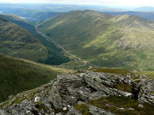
Looking into Glen Kinglass.
Visit Scotland
Discover Scotland
Undiscovered Scotland
The Scottish Mountaineering Club
Munro Magic
Hill Phones
Buachaille.com
The Mountaineering Council of Scotland
Walk Highlands