
|
|
Mountain/Rock |
|---|---|
|
|
47.09851°N / 11.03102°E |
|
|
Mountaineering |
|
|
Spring, Summer, Fall, Winter |
|
|
10784 ft / 3287 m |
|
|
Overview
The Breiter Grieskogel (also: Grieskogel) is located in the western Stubai Alps, in the Larstiger mountains between Sellrain and Hochstubai. The name "Grieskogel" refers to the village of Gries, which is at the south side of the mountain. "Breiter" means wide, which refers to the shape of the mountain, which is rather hill shaped. Still, the Breiter Grieskogel is a very prominent mountain. The Breiter Grieskogel can be climbed in the summer and winter by several routes. Most popularly is the climb from the Winnebachsee hut. The Summit offers a great view towards the ötztaler Alps and the Stubai Alps.The area around the Winnebachsee Hut very popular throughout the year. There are numerous possibilities for backcountry skiers, alpinists, climbers and hikers. The Winnebachsee Hut is a very cosy traditional mountain hut and worth visiting! A dive into the lake behind the Hut is one of the fine things about the area.
 The Breiter Grieskogel.
Getting There
In general:On the Inntalautobahn A-12 take the driveway Ötztal. Through the Ötztal until Langenfeld, there to the left to the mountain climber village Gries.
Parking possibility: At the eastern side of Gries, take the road that leads to the village Winnebach. One turn before Winnebach there is a parking lot. The second possibility is at the end of the village gries.
To the Winnebachsee Hut:
From the cottages at the parking lot to the village Winnebach. From here to the right to enter the Sulzvalley. Follow the valley to a blocking rock bar, then go right (east) and one reaches a small lake (2215m). Further over a steep cliff upwards to the Winnebachsee Hut. The way up is a two hour walk.
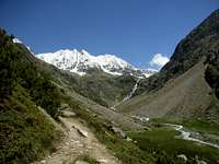 On the way to the Winnebachsee Hütte.
 Routes
Normal route from the Winnebachsee Hut:From the Winnebachsee Hut, take the path to the left of the lake (northern direction), which leads you into the Winnebachkar. Turn left at the sign and climb in direction northwest untill you nearly reach the Zwieselbachjoch (at about 2800m.). Then head west to the Grieskogelferner. The Grieskogelferner has a steep section with several crevasses, which can be passed at the left side of the glacier. The last part of the climb follows the north ridge of the summit.
Winnebachsee Hut --> Breiter Grieskogel 3,5 - 4 hours. Alpine climbing grade: F/L.
Maps and Guidebook
Maps:* Kompass Map Nr. 83 Stubaier Alpen 1.50.000
* AV-Karte Nr.31/2 Stubaier Alpen/Sellrain 1:25.000
Guidebook
* Guidebook Rother: 1271, Stubaier Alpen, Walter Klier
External Links
The Winnebachsee hut:Telephone: 0043/(0)5253/5197
E-mail: winnebachseehuette@aon.at
Website:Winnebachsee Hut
Other usefull links:
* Weather forecast
* Avalance Bulletin
* Time Table Bus
* Time Table Train