
-
 17685 Hits
-
 89.77% Score
-
 30 Votes
|
|
Mountain/Rock |
|---|---|
|
|
36.95552°N / 4.55572°W |
|
|
Hiking, Bouldering |
|
|
Spring, Summer, Fall, Winter |
|
|
4383 ft / 1336 m |
|
|
Overview
 Rock Labyrinth Rock Labyrinth |
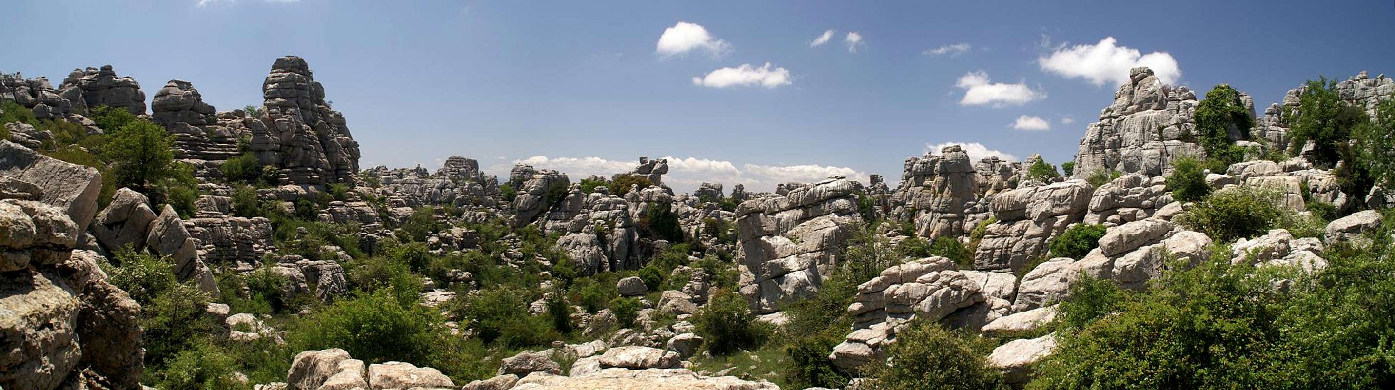
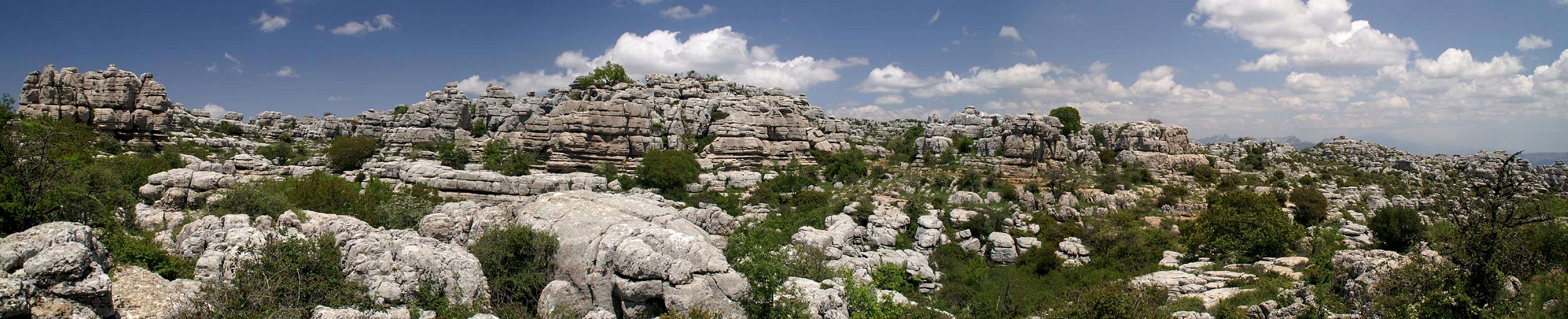
In Andalusia (Spanish Andalucia), in the province of Malaga, you can find a small mountain range which is unique among the mountain ranges on this planet. To the south of Antequera, between the town and the village of Villanueva de la Conception it stretches for 4 km from north to south, 8km from east to west almost forming a half circle when seen from above. Its name is El Torcal and it probably is the main natural attraction of the province of Malaga though this province by no means is short of these kinds of attractions.
El Torcal is made up from limestone. The range rises for about 500 - 600m out of the hillscape around Antequera. Like many limestone mountain ranges it has steep faces on its outside while its top is one vast plateau. As so often with limestone plateaus the one of El Torcal displays karst phenomena - caves, crevices, bizarre rock formations - but nowhere on this planet are they as pronounced as here. The whole plateau is one veritable labyrinth of rocks with the full panopticum of structures on display. Much of it reminded me of photos I had seen from Angkor in Cambodia though more expansive. The architect of El Torcal certainly had bigger things in mind. I suggest you have a look at the interactive map. What you will see is a "city of rocks" stretched out to the south of Antequera, complete with buildings, streets and alleyways between them.
 Balancing Act Balancing Act |  Trio of Towers Trio of Towers |  Decorated Rock Decorated Rock |  Thumb Thumb |
El Torcal is a very popular destination. wikipedia claims that up to 100000 persons visit it each year. Additionally for the folks of Antequera aand Villanueva it serves as a weekend getaway. On weekends, be prepared to find hundreds of picnics beside the road that leads to the top of the range. This road is the only allowed access to El Torcal. The range was marked as a Natural Site of National Interest in July 1929 already, and a Natural Park was created in October 1978, containing about 17 square kilometres of the range. Apart from two short hiking trails which you can find near the park's visitor centre, the range is off limit to all kinds of activities. Hiking is restricted to the two routes, Ruta Verde and Ruta Armadilla. As for climbing, there are currently some banned areas close to the visitor station, but most routes are allowed. There is a lot of development going on at the moment which has included establishing a couple of Via Ferrata routes.
 Thin tower Thin tower |  Standing Tower Standing Tower |  Pagoda Pagoda |  Leaning Tower Leaning Tower |
El Torcal is home to many different animal and plant species. They counted more than 80 types of birds and 20 types of mammals, including the Iberian Ibex. Also, there are more than 600 species of plants, among them 30 orchid species, 6 of them endemic in the range. Leaving trails would endanger many of them and isn't advisable anyway due to the labyrinthine nature of the place.
 Pulpit Pulpit |  Fortress of Towers Fortress of Towers |  Pagoda Pagoda |  Twin Towers Twin Towers |
The foundation of El Torcal were laid in the jurassic period 150 million years ago. Sediments were laid down in a sea which existed between today's Cadiz and Alicante. In the tertiary period the ground level rose to about 1500m, exposing these sediments which had already settled into limestone rock. From that period onwards the range was exposed to wind and rain, snow and ice, which eventually cut deep crevices and alleyways into the rock (karstification). Underneath - like with any karst region - there are many caves, some of them home to stone age man during the neolithic period.
 Twin Towers Twin Towers |  Spire Spire |  Overhanging Tower Overhanging Tower |  Erosion Tower Erosion Tower |
As a mountain, El Torcal is not overly impressive. Its highest summit is Camorro de las Siete Mesas (1336 m), slightly to the east of the natural park's visitor centre. Geologically the range is divided in four sections - Sierra Pelada, Torcal Alto, Torcal Bajo and Tajos and Laderas. The weird karst formations can only be found in Torcal Alto.
Panoramic View of El Torcal
  |
Getting There
 Alleyway beneath the rocks
Assuming you arrive at the airport of Malaga, take the city motorway A357 northward to the intersection with A7 and A45 north of the city. There turn onto A45, direction Cordoba, Antequera.
At the exit Antequera leave and head for the town. There are signs for El Torcal here already but you have to drive through Antequera for quite a while to get to MA424, which connects the town with the mountain range. After a sharp turn in the road, which takes you through a saddle a side road turns off left, leading directly to the top of El Torcal.
Red Tape
 Ophrys tenthredinifera
 As mentioned in the overview section, El Torcal has been declared Parque Natural El Torcal and thanks to the many species of animals and plants which are at home in the range almost any activity is restricted to the road to the visitor centre and the two short hiking route through the labyrinthine plateau. Climbing and bouldering are not allowed but neither is picnicking. Still you find a lot of picnic parties and an occasional boulderer can also be found in the remoter parts of the plateau.
Accommodation
 |
The Costa de la Sol is one of Europe's major vacation getaways and there are all types of accommodation to be found. Hotels, apartments, fincas can be booked from any tourist office all over Europe and there are many sites on the net which deal with the area.
The closest campground is on MA424 between Antequera and El Torcal. It accompanies a very popular picnic zone north-east of the Sierra Pelada of Torcal.
Weather Conditions

Maps & Books
As for maps - I haven't been able to find a decent one, which includes El Torcal. To get there I used:Andalusien
Die Generalkarte
Mair Dumont Verlag
1:200000
ISBN: 978-3-89525-232-7
As hiking guidebook I can recommend the following one which is available in German and English
Andalucia South / Andalusien Süd
Costa del Sol – Costa de la Luz – Sierra Nevada
Bernhard Plikat (translation: Gill Round)
Rother Verlag
ISBN 978-3-7633-4824-4 (English)
ISBN 978-3-7633-4147-4 (German)
There are two climbing guidebooks, which also deal with El Torcal:
El Chorro
Rockfax climbing guide
Mark Glaister
Rockfax Ltd
ISBN 978-1873341810
Andalucia
Guia de escalada seportiva
David Munilla
edicones Desnivel
ISBN 978-8498290974
SilviaFitz - Nov 17, 2009 10:49 am - Hasn't voted
Climbing at El TorcalI should just point out that climbing is allowed at El Torcal and is documented in a couple of books (El Chorro Rockfax ISBN 978 1 873341 81 0) and David Munillas "Andalucia". There are currently some banned areas close to the visitor station, but most routes are allowed. There is a lot of development going on at the moment which has included establishing a couple of Via Ferrata routes.
Gangolf Haub - Nov 17, 2009 1:31 pm - Hasn't voted
Re: Climbing at El TorcalThanks a lot for the information. My information was that climbing was banned. I took the liberty to use your very words on the page (see third paragraph at the end). I hope you don't mind. I also added the two books you mentioned in the last section. Thanks again!