
-
 12510 Hits
-
 83.09% Score
-
 16 Votes
|
|
Mountain/Rock |
|---|---|
|
|
32.82432°S / 69.80867°W |
|
|
Hiking |
|
|
Summer |
|
|
12093 ft / 3686 m |
|
|
Overview

Cruz de Caña is a hiking mountain in the Aconcagua Group.
For an aspirant of climbing Aconcagua it is a perfect mountain for the first acclimatization climb before entering the Aconcagua National Park. If you start your holiday from sea level or so, it is a reasonable tactic to stay two nights at the still moderate height of the Horocones valley – for example at Penitentes ski station.
For this full day there you may climb as high as you feel comfortable without getting a headache or becoming too exhausted. Therefore Cruz de Caña with its 1100m ascent is reasonable goal – and a nice one in beautiful landscape. It is nearby the Penitentes ski facilities but does not touch them.
Getting There
 Penitentes (2580m)
Penitentes is at the main road from Mendoza to Santiago de Chile, 7 km east of Puente del Inca.
Normal route
 route in red
From Penitentes (2580m) first walk some meters along the main road in direction to Mendoza until you have passed the creek. After some meters leave the dirt road and gain the grassy ridge to your left. A track of footprints shows that you have found the right route. Follow this ridge – sometimes steep - until it ends at a plateau at app. 3120m. Nice and easy hiking from here. Follow the grassy slopes further on (one steeper section) and head for the ridge that connects Cruz de Caña to Cerro Mario Ardito on the right. Actually there is no ridge but a broad slope. There you see footprints again on the slopes that lead to the summit interrupted by a short rocky section where you may need your hands for some meters.
3 to 4 h for the ascent, depending on fitness and acclimatization status.
Descent on the same route. Some nice short cuts possible in soft scree at the upper parts where there is no vegatation.
map sketch

Gear
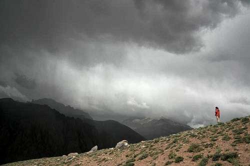 snow shower coming
normal hiking gear is sufficient. Walking poles are recommended for those who are used to it. If it is hot in the Horocones valley be aware that it might become cold and very windy in the upper parts. We started our climb at fine weather but witnessed a short snow shower. That was not so fine for those that walked with short trousers.
Red Tape

No Red Tape as I know because the mountain is outside of the Aconcagua National Park.
When to climb
In the times of the year when you can climb Aconcagua you can also climb Cruz de Caña.The slopes of the mountain would make it an interesting ski tour. As the ski lifts of Penitentes are just nearby, snow amount and climate in winter time should also fit. Probably you can do a "ski plus" with using the lifts for shortening the ascent.
Accomodation
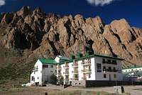
We stayed at Hotel Ayelen in Penitentes that I can recommend.
Camping
A campyard is at Puente del Inca, 7 km from Penitentessome normal route pictures
 road walk road walk |  grassy ridge grassy ridge |  gentle slopes gentle slopes |
 upmost green upmost green |  hiking in scree hiking in scree |  last meters last meters |
poice2004 - Sep 5, 2008 1:24 pm - Voted 10/10
With ÑCruz de Caña with "Ñ" "Puente del Inca" like a bridge not Punte Very nice page.
Mathias Zehring - Sep 5, 2008 1:39 pm - Hasn't voted
Re: With Ñthanks for your comment! I'll correct Puente del Inca. I've read about the sign above the "N" - but I cannot produce this with my German keyboard. Is there a correct replacement with international keyboards possible (like the german "ä" can be replaced by "ae")?
poice2004 - Sep 5, 2008 2:01 pm - Voted 10/10
Tryalt + 164 or alt + 165
Mathias Zehring - Sep 5, 2008 5:32 pm - Hasn't voted
Re: Trydid not work - but here I found the solution, fixed the text and two dozen picture captions. I hope everything is okay now! Can you tell me, what the name of the mountain means translated to English? Would be nice to mention on the page!
poice2004 - Sep 6, 2008 12:36 pm - Voted 10/10
Re: TryCruz de Caña more or less #Cane Cross"