
|
|
Mountain/Rock |
|---|---|
|
|
35.83850°N / 81.8943°W |
|
|
Burke |
|
|
Hiking, Mountaineering, Trad Climbing, Sport Climbing, Toprope, Bouldering, Ice Climbing, Aid Climbing, Big Wall, Mixed, Scrambling |
|
|
Spring, Summer, Fall, Winter |
|
|
3000 ft / 914 m |
|
|
Overview

Southern End
Shortoff is on the southeast side of the gorge. It's relatively easy to reach via a short spur trail and the Mountains to Sea Trail. The only difficulty in getting to the summit from this point is that the spur trail is badly eroded and the going is extremely muddy in wet weather. I think that the trail needs some major work, or that it should be closed. It was originally created by rock climbers who needed a short, quick hike to the top of the cliff walls of Shortoff. As such, it was never an official trail and suffers the consequences of lack of grading and water breaks.
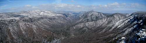
From the summit of Shortoff! One of the best views in the Gorge!
The slopes of Shortoff Mountain were badly burned during the hideous fires of the drought of 2002 and the even fiercer fires of the drought of 2007. These fires were so destructive that they quite literally burned everything. Every type of tree fell to the fires, and even the rhododendron, which normally bounce back after a fire, were left as charcoal. And the heat was so powerful that the loam burned off, leaving only the mineral soils. Vast swathes of the gorge now appear brown when viewed from a distance, looking more like desert territory than classic southern Appalachian highlands.
But a good section of the mountain was spared the worst of the fire and the forest is in reasonably nice shape in those areas. Shortoff is covered with great campsites and miles of easy walking along the heights of the southern gorge and along massive clifftops. There are also good water sources along the Mountains to Sea Trail on the ridges of Shortoff.
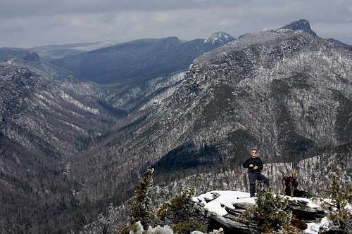
Bob and Boone
One feature that Shortoff boasts, and which is not widely known, is a pond. Anyone who knows the geology of the Southern Appalachian mountains understands that there are almost no natural lakes or ponds here. You can count them on one hand. The most famous ones are Mountain Lake in Virginia and Trout Pond in West Virginia. Other than those, it's almost unheard of to see a naturally occurring pond in the mountains of the southern USA.
But Shortoff Mountain has one of two that are located in the wilderness. The one near the summit of Shortoff is the larger of the pair. It's not a big pond by any definition. Half an acre, perhaps, with a depth of not more than three feet at most. During excessive droughts (as the ones in 2002 and 2007), the pond has been known to completely dry up. But generally it's quite evident and a constant flow is visible if you watch it. It is obviously spring fed and the pond flows into an underground stream that reappears about forty vertical feet lower and about one tenth of a mile east as a clear, gushing spring.
Shortoff is also one of the major rock climbing destinations in Linville Gorge. Its walls are very popular and packed with routes of all types. Everything from easier Class III to very tough technical routes.
If you have some time to spend in Linville Gorge, you can't do any better than a hike or a climb on Shortoff Mountain.
This is the small pond/tarn on the summmit area of Shortoff. Very unusual!
Getting There
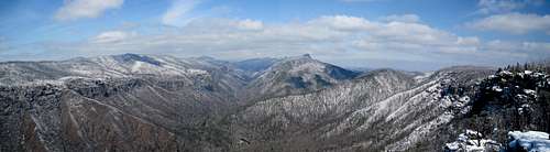
Summit Panorama!
From I-40 take Exit 105 for 2.2 miles. Take exit 103 for US-64 toward Morganton/Rutherfordton0.2 miles. Thenturn right at Burkemont Ave/US-64 E
0.7 mi. Turn left at Fleming Dr/US-64 Bypass W for 1.1 miles. Take the 3rd left onto W Union St 0.2 miles.Continue onto Carbon City Rd 0.8 mile. Turn right at Independence Blvd 0.8 mile. Take the 1st left onto State Hwy 126 and drive 11.2 miles. Turn right at National Forest Rd/Wolf Pit Rd and drive to the end where there is a turnaround and some limited parking. The trail begins at the top of the loop and is obvious (very eroded) going up through the burned forest. You will also see an official Wilderness Area designation sign.
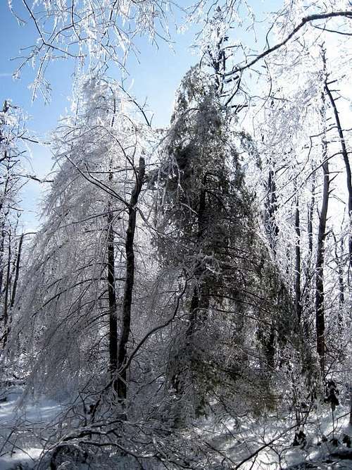
Frozen Forest
Red Tape
All wilderness rules apply.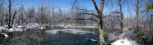
One of Linville's Ponds.
Camping
There is ample camping throughout the Linville Gorge Wilderness. There many great campsites along the Mountains to Sea Trail as it passes over the long ridge of Shortoff Mountain.As the sun came out, the ice began to expand and sing in the forest.
External Links
Linville Gorge Wilderness Area.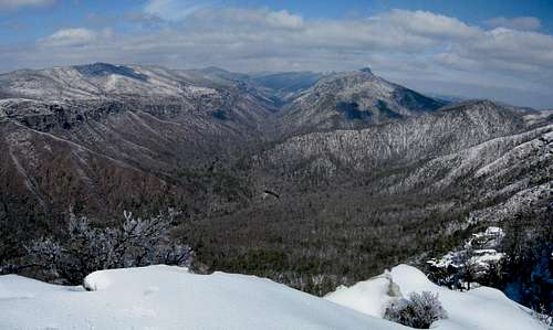
Looking North