
|
|
Mountain/Rock |
|---|---|
|
|
47.68587°N / 12.89297°E |
|
|
Hiking |
|
|
Summer |
|
|
5705 ft / 1739 m |
|
|
Overview
 Karkopf summit with cross
 Karkopf summit with cross seen from below
As can be seen on the two images, the Karkopf, like nearly everything else in the Lattengebirge range, is entirely covered in pine vegetation, except for the summit itself. Even if heightwise you cannot call it a major peak of the Berchtesgaden Alps, I can strongly recommend not only the summit itself, but also the trail leading to it for some of the most remarkable views upon the Watzmann group you can get. It's from this trail that you get the impression of Watzmann and Hochkalter as "wild" mountains, with a nearly "Canadian" character. This is what makes me call the Predigtstuhl-Karkopf trail a "secret tip"! I hope later on to go back up there on a really clear day, without heat haze, and shoot better photos upon the panorama in that direction.
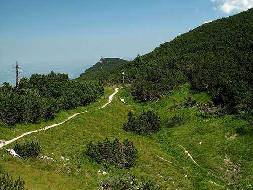
 Great views from the Hochschlegel on the Karkopf trail
 View from the Karkopf
Getting There
The main place to head for at first is Bad Reichenhall. From Bad Reichenhall, there are the roads (all in excellent condition) leading either westwards in the direction of Lofer-Innsbruck via Unterjettenberg to Taubensee (at Unterjettenberg, turn left and follow the B 305 in the direction of Ramsau-Berchtesgaden) or along the east side of the Lattengebirge (B 20) past Bayrisch Gmain, Hallthurm and Bischofswiesen to Berchtesgaden. Selboden is on this road.Nearest airports to Bad Reichenhall: Munich, Salzburg.
Coming by car: From Munich, take the motorway bound for Salzburg and exit at Bad Reichenhall. Distance (from the Franz-Josef-Strauss-Airport): 171,9 km, duration: 1 h 41 min.
From Salzburg, follow the signs to Innsbruck and take the road leading over the Walserberg (national frontier) via Schwarzbach-Marzoll to Bad Reichenhall. Distance (from Salzburg Airport): 12,5 km, duration: 15 min.
Coming by train: Alight in Freilassing, the border station on the Munich-Salzburg line, and take the train bound for Berchtesgaden. All trains stop in Bad Reichenhall. From Salzburg there are also direct post-busses.
Routes
One can save oneself already four hours of ascent by taking the Predigtstuhlbahn from Bad Reichenhall-Kirchberg to the Predigtstuhl and then following the trail along the crest, first descending gently towards the Schlegelmulde col, on which there is also a restaurant, then rising 140 meters to the Hochschlegel on 1688 meters. From here, follow the trail leading along the crest, past a lot of pine vegetation (here is where you get my favorite views upon Watzmann and Hochkalter!), descending slightly (only here does it get a bit steep) and then rising past a col to the summit of Karkopf (1739m). This takes about 1 hour and a quarter.What is recommendable is to descend from the summit by following the trail no. 479 leading south, first to the col separating it from the Törlkopf (1704m), then around the Törlkopf to the Törlalm, and here, turn left and follow the path leading down through mountain forest to the beautifully situated Mordaualm on 1191 meters. From here, follow the forest road down to Taubensee, 2 km north west of the village of Ramsau. This descent takes about two and three quarters of an hour.
 The Schlegelmulde
 View from the Karkopf towards the south
The trail no. 477 from Winkl-Selboden (685m) at the eastern foot of the mountain takes you first steeply up through mountain forest, then past a remarkable mushroom-shaped rock formation named "Steinerne Agnes" ("Petrified Agnes") on approximately 1300 meters, then horizontally for about 900 meters length, a steep rise through a mixture of scree and pine vegetation to the col between Dreisesselberg (1679m) and Karkopf, turn left and follow the trail through a very pretty alpine "basin" to the Karkopf's summit. Duration: about four hours. Not difficult.
 At the foot of the Karkopf, looking towards the Dreisesselberg
Of a more adventurous nature is the Alpgartensteig trail (no. 477) leading from Bayrisch Gmain at the northern foot through a steep and narrow wooded valley and then very steeply over rock and scree to the Hochschlegel, from which you follow trail no. 404 A to the Karkopf. This is one for the more experienced walkers, as one should not have fear of exposure. Duration: ca. 4 hours.
 Dreisesselberg from the top of the Alpgartensteig trail
 On the Alpgartensteig trail
An easier variation would be: turn left at pt. 800m and follow trail no. 479 over the summit of the Dreisesselberg to the Karkopf.
 The Dreisesselberg
Camping
No camping allowed on the mountain, but the villages in the vicinity of the Lattengebirge range, such as Ramsau, Bischofswiesen and Bad Reichenhall offer possibilities.External Links
Schedule for the "RamBus", the Ringlinie Ramsau (stops at Taubensee)The Predigtstuhlbahn (unfortunately there is no English translation)