
|
|
Route |
|---|---|
|
|
44.10546°N / 113.77687°W |
|
|
5 |
|
|
III |
|
|
Overview and History
 Mountaineers Route-Red Kevin and Cory finished the East Face Direct-Blue a few weeks later.Photo by Kevin Hansen
Route Narrative by:Kevin Hansen
In Idaho’s tallest range, there are some gems that remain hidden from the spotlight. They remain hidden because they are hard to get to, they require technical climbing, and they are best climbed one or two months a year. The Mountaineer’s route on Mount Idaho’s east Face exactly that. It was first climbed by Wes Collins and Kevin Hansen on Aug 25th, 2012. Few who camp at Miriam Lake escape the beauty of the East Face of Mount Idaho. This climb is truly a prize for any aspiring alpine climber in Idaho. Because the rock is surprisingly sound, the protection is abundant, and the views are second to none, this route gets five stars and is highly recommended.
Getting There
From U.S. Hwy 93, 46 miles north of Arco (32 miles southof Challis), follow FS Road 116 northeast over Double springs
Pass for 10 miles to the turnoff of FS Road 117. Look for the Horse Haven Pass sign. Follow 11 7 over Horse heaven Pass for 6 miles to the junction with FS Road 118. Follow 118 up the West Fork Pahsimeroi River for
4.5 miles to its junction with FS Road 267. Follow 267 for 2.5
miles up the West Fork Pahsimeroi River to the end of the
road. The FS Trail to Merriam Lake begins near the end of the
road.
Once at Miriam Lake TH follow the stream for a few hundred feet till a wooden sign points right away from the creek. Stay on the well-used trail up several steep hills to gain enough elevation to reach the Lake. You may camp on the East side of the Lake, or continue around the North shore to more camps higher up. From here continue West up the scree slopes and moraines (tank up! This is the last water till you came back.) Eventually the slopes lead to the base of the wall. You may find climbing the class 3 black rock band easier than the scree hiking as the FA team did.
Route Description
 Kevin following pitch 5.
P1 of the Mountaineer’s route, starts in a crack system just left of the obvious right facing dihedral chimney in the middle of the wall. This crack system takes pro easily and is a fun 5.7 climb up 70 degree rock. The top half of the pitch is composed of banded iron dolomite which can be loose, but is mostly solid, and gear placements will be in thin horizontal cracks. Protection can be tricky, but the climbing calms down to 5.5 as well.
P2 is more low angle 5.5 to 5.6 climbing and gear goes in easy, and ends on a large ledge below two right facing dihedrals.
P3 follow the middle hump between the two dihedrals on a rounded 5.8 arête’. Potential variations include the chimney to the left, or the beautiful crack system up the face of a small tower on your left. One might be tempted to climb to the right, but staying on the arête will provide a few gear placements and fun exposed climbing.
P4 is a long up and leftward 5.4 and 5.5 scramble on 70 degree rock. No gear was placed by the FA team however there are many places to protect a fall. The rock has many small ledges covered with gravel. Simply clean and tug. The quality of the limestone is very high and risk of falling is very low. Feel free to build a belay just about anywhere.
P5 starts with a 5.6 traverse left (south) to steer clear of the steep overhanging headwall. Once around a corner, a long full pitch of 5.6 climbing up a 60 degree six foot wide chimney/rain gutter will lead you to the summit of the East Face. Mount Idaho’s true summit is further East along a tricky ridge system. Route finding along the top of the North Face is not easy even though you are on easier ground.
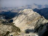 Merriam Lake from the top of the Diamond wall.
 Descent
From the top of the Diamond of the East Face, walk due North till you can see a long obvious class 3 scree slope leading down to the start of the North Face Cirque. The cliff edge of the East face will be 20-30 feet on your right and the North Face will be on your far off left. Follow the path of least resistance till the North Face Cirque drainage meets with the East Face Drainage. Follow the water down till you reach Miriam Lake.Gear
Unlike other Lost River Alpine climbs, this route prefers wider gear. Most gear placements will range from fingers to fist size and the more wired nuts the better. Leave the micro nuts and cams at home. Bring a dozen 2 foot runners/slings to extend placements. The climbing difficulty doesn’t require a lot of gear placements, which makes this a very beginner friendly climb. The FA team used a 70 meter rope and even though belay spots are abundant, they stretched it out to get the most out of the rope. This route could be easily done with a 50 meter rope and would probably be 6 or 7 pitches.Late summer and early fall are the best times to climb this route. As with many LRR climbs the less snow on the face, the less chance of rock fall.