
|
|
Mountain/Rock |
|---|---|
|
|
50.20550°N / 126.31657°W |
|
|
Hiking |
|
|
Spring |
|
|
5906 ft / 1800 m |
|
|
![Mt. Abel]()
Mt. Abel
Mt. Abel
Overview
 Mt. Cain view |  Mt. Cain |
Mt. Abel is a great hike for those looking to hike an area that is less travelled, but still provides access to beautiful alpine and isn’t a huge time commitment. The total distance one way is about 5.5 km, with the entire hike taking under 6 hours. The peak offers stunning views of nearby Mt. Cain. There is no flagged route and really not much sign of anyone hiking this peak, although it was only May when I crossed it off my list. No sign of any rock cairn or log book at the peak, but this may also be due to the depth of the snow.
Getting There
After leaving Campbell River and heading north for about 1.5 hours (roughly 121 km) you reach the Mt. Cain turn off. This road is fairly well maintained due to the ski hill. Follow the Mt Cain road for about 7.5 km until the junction of Adam road. Follow this for another 4 km to the junction of AD8000, just past a small rock quarry on the left hand side. The road is still in good condition at this point, but as you follow AD8000 the road starts to have some pretty good cross ditches. Follow this as far as possible into the new slash, then get out start bushwhacking (see Map below).Route

Google Earth Map
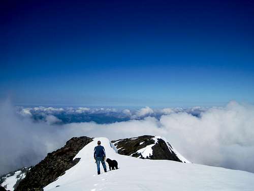
 New Slash Looking up at Mt. Abel |  |  Upper Bowl |  East Ridge |  Near the Peak |  Mt. Abel's Peak |
Red Tape
No red tape at the moment, although there is a few patches of nice standing timber so I would expect them to come back in and do some more logging there in the near future.When to Climb
Road access is limited fairly far down, so the only real issue to hiking this at any time of the year is snow depth and quality. In the upper bowl there is evidence of avalanches, so just keep that in mind.Photos
 Looking back at the starting point |  East Ridge |  Indy and Maquilla Peak |  Upper Bowl |  |
 Ptarmigan |  |  Looking back from the peak |  |  |