
-
 25449 Hits
-
 82.48% Score
-
 15 Votes
|
|
Mountain/Rock |
|---|---|
|
|
41.218°S / 172.68201°E |
|
|
Hiking, Mountaineering, Skiing |
|
|
Spring, Summer, Fall, Winter |
|
|
5889 ft / 1795 m |
|
|
Overview
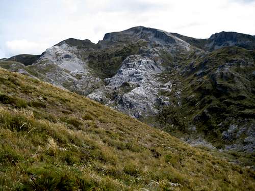 Mt Arthur from the approach Mt Arthur from the approach |
The geology of the area, including the adjacent Tablelands, is characterized by hard, crystalline marble derived from the original limestone seabed of some 450 million years ago. Aeons of glacial scouring and water erosion has left a system of sinkholes and caves, many of them unexplored and renowned throughout New Zealand. A hike up Mt Arthur provides lots of opportunities to sample this unique morphology.
In good weather the summit can easily be hiked as a day trip from cars. However, there is a nice hut right at treeline for those wishing to take their time. In early season or bad weather all bets are off. When there is snow on the ground be prepared as you would for any winter ascent. A wind-slab prone cirque with an unpleasant looking run-out below the main summit requires some care. In fact I’m told that locals usually head up the aptly named subsidiary “Winter Peak” just to the southeast when conditions look iffy. Nevertheless, Mt Arthur is climbed year round and is a popular ski/snowboard destination for locals.
Note that mountain biking is illegal anywhere in Kahurangi National Park.
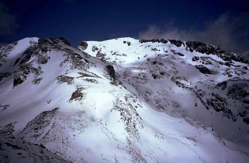
Mt Arthur from the approach in early season
Getting There
Approach from Nelson or Motueka and make your way to the Motueka Valley Road – also known as “Old Highway 61” – as follows.
Mt Arthur direction sign
From Nelson take SH 6 to Kohatu and turn right following signs for Tapawera.
From Motueka pick up the Motueka Valley Road just south of town. The DoC office is on the corner where you make the right turn.
If you’re coming from the south (Nelson) cross the river at Richmond to the West Bank Road and turn right following the yellow AA signpost for the Mt Arthur track. From the north (Motueka) cross the river at Ngatimoti and turn left, also following AA signs. The unsealed Graham Valley Road is at about the midpoint between the two crossings. Turn west and drive approximately16 km up to the carpark on the Flora Saddle. The last 10-11 km is steep and wash-boarded. A steep section near the bottom has been semi sealed to help traction. Nevertheless, the road might be a problem for a 2WD vehicle in the wet and it certainly would be in snow.
At the carpark at ~1,000 metres elevation there is a shelter with a track information sign, a coin telephone and toilets.
Approach/Route
From the carpark walk for 5-10 minutes in the direction of the Flora Hut before making a left turn for the Mt Arthur Hut. The track is benched, nicely graded and arrives at the hut just over an hour from the start. There is a rainwater tank at the hut. Fill up because water is scarce from this point. Arthur Hut track on a snowy morning Arthur Hut track on a snowy morning |  The welcoming Arthur Hut The welcoming Arthur Hut |  Arthur Hut tracks sign Arthur Hut tracks sign |
Pick up the onward track at the far (west) side of the hut compound and follow the poles south, west and then south again along the lovely open ridge. The summit comes into view 15 minutes above the hut at the top of the first significant rise. The route is well marked and easy to follow as it meanders back and forth amongst the tussock. About halfway along the ridge a marked track drops off to the west and down to the Tablelands.
  |

"Winter Peak" in summer conditions

Winter alternative
Also worth bearing in mind when there’s snow on the ground is the fact of all those limestone sinkholes that could be hidden. The poled route keeps well away from any such hazards so keep carefully to the marked route. Should you lose sight of the poles for any reason, tread carefully!
If the going is clear proceed into the cirque between the two peaks and follow the track north, west and then north again up to the summit ridge. Turn right and walk up to the trig in 5 minutes.
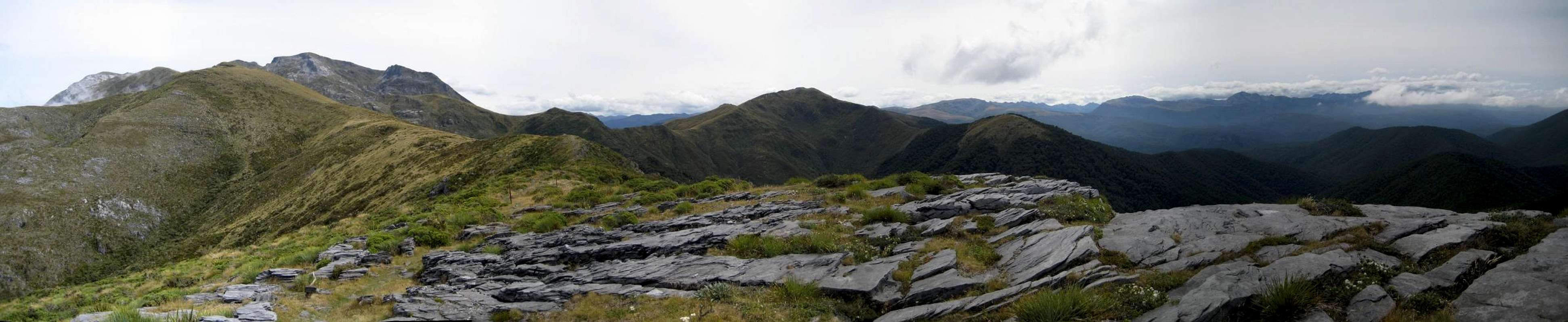
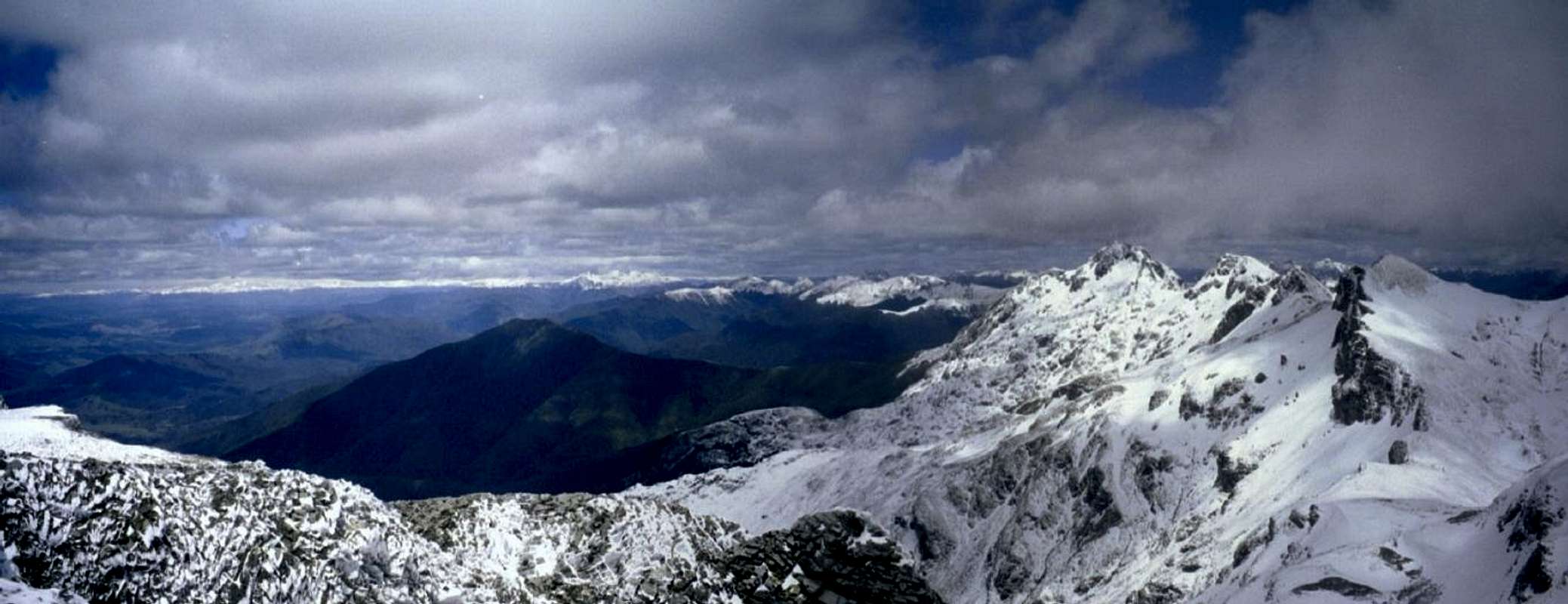
Close at hand are spectacular views southeast to the bald limestone “Twins”, north down to the Tablelands and northeast to the approach ridge. There are also wonderful views down towards the Southern Alps and east over Tasman Bay to Nelson.
Descend by reversing the above.
The total distance is approximately 19 km with ~1,100m of total relief. Round trip time from the carpark; 5-7 hours including breaks. From the hut 3-4 hours return.
 Sinkhole in the limestone Sinkhole in the limestone |  Summit view to The Twins Summit view to The Twins |  Summit view east Summit view east |  Descending Mt Arthur Descending Mt Arthur |
Red Tape and Safety Considerations
As with all serviced huts in New Zealand, there is currently (2009) a “three ticket” ($15) charge per person per night for the Arthur Hut. Better value than this is a season pass. A 6 months pass valid for all serviced DoC huts – but not “Great Walk” or alpine huts such as the Muellar Hut – costs $60. This pays for itself after just 4 nights. A no-brainer in my opinion.DoC operates a well-organised intentions system. Particularly if you’re travelling alone, you’d be well advised to complete one of the forms available at the office in Motueka or in the shelter at the Flora Saddle carpark. If you forget these, you can still cover yourself by completing the visitor book in the Arthur Hut.
I noted cell phone service from the summit of Mt Arthur but didn’t check it anywhere else on the route.
Camping
Camping is permitted anywhere in Kahurangi NP. The Mt Arthur hut is not as palatial as its “Great Walk” cousins but is perfectly adequate, has a lovely welcoming feel to it and is in a great location right at treeline. On the two occasions I’ve been there I haven’t had to share it with anyone other than my hiking companion.Giardia is documented in the park, so boil or treat all water.
Useful Links
Kahurangi National ParkWeather. The forecast for Motueka will likely reflect the most accurate prediction for Mt Arthur. New Zealand, however, is notorious for awful mountain weather just a few kilometres from the nearest sunny beach. Check the alpine forecast with DoC before you venture onto this and any other mountain in the country.
Summit Views
 |
 |