-
 4074 Hits
-
 71.97% Score
-
 3 Votes
|
|
Mountain/Rock |
|---|---|
|
|
50.21340°N / 114.75114°W |
|
|
Scrambling |
|
|
Summer |
|
|
9501 ft / 2896 m |
|
|
Overview
Mt Farquhar 2,896m, (not to be confused with the mountain of the same name in California, named after a different Francis Farquhar) is located at the head of Cataract Creek on the border of British Columbia and Alberta. The peak is named after Lieutenant Colonel Francis Douglas Farquhar, DSO. The information in 'Place Names in the Canadian Alps' is not quite correct. The book states: “Major Francis Douglas Farquhar (1874-1915), DSO 1900 for his service in the Boer War, commanded a battalion of the Coldstream Guards and was killed in World War I” (Glen Boles, “Place Names of the Canadian Alps, 100). In fact, Lieutenant Colonel Francis Douglas Farquhar, DSO, an officer with the Cold Stream Guards prior to World War One, became the first commanding officer of Princess Patricia's Canadian Light Infantry formed at the beginning of the war in August 1914. He was a respected leader and is credited with instilling much of the discipline and fighting spirit within the Regiment and led it through its first months in the trenches. He also had service in the Boer War and in Somaliland. He was killed while conducting a relief in place on 21 March, 1915, at St Eloi, Belgium. The mountain was officially named by the Geographic Board of Canada (GBC) on 4 November 1919. Since then it's remote location and challenging scramble have led it to have few ascents. A summit register removed in August 2015 had only 2 entries dating back to 1996. According to the Alpine Club of Canada Journal Vol 69 1986, the first ascent of the peak was by TS Sorensen and MH Benn in 1973. Expect a long day, 34km round trip with 21kms of biking.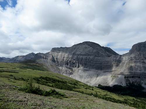 Mt Farquhar.
East Ridge Route
The Gemtrek map, Highwood & Cataract Creek, provides an excellent overview of the area. From the East, the easiest line to the summit is the East Ridge off Cataract Plateau. Park on Rte 940, 11.6km S of HW40, at a pullout at the Lost Creek/Cataract Creek Road. From here, bike downhill to the creek then west on the old Cataract Creek road. The first two bridges are out, but foot bridges exist further upstream. Cattle ranching in the area has created a decent track making the ride much easier. 5.4km from where you parked the old faint main road turns south and becomes Lost Creek Rd, but the bridge is out. Continue west along Cataract Creek following a good trail/road that is used by snowmobiles in the winter. There are some branches off this trail but stick roughly left along the creek. You will cross the creek once at about 1.7km from the Lost Creek junction, then cross it again at 2.5km. Bridges at both crossings. Approx 5km from the Lost Creek junction, and shortly after passing a small cabin on the right of the trail, the main snow mobile trail will veer to the north. Watch for a foot trail on the left marked by blue paint on the trees. This is a short connector to the Great Divide Trail, which is reached after a 2 min walk. Turn left downhill, and follow the good trail with orange paint marks on trees as it takes you up onto Cataract Plateau. In August the creek was the last option for water before the plateau so make sure you have enough from here. Once you clear the trees, follow the Great Divide Trail along the ridge line, then veer off heading towards the East Ridge of Mt Farquhar across the beautiful Cataract Plateau. 5kms from where you joined the great divide trail. 2 hours of biking, 2 hours car of hiking gets one to the start of the scrambling.
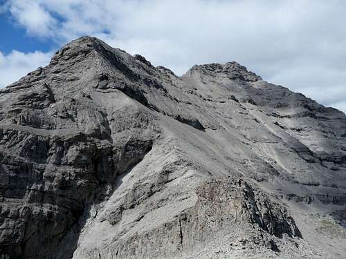
Once at the base of the ridge, the ridge itself can be followed for some distance but at the first saddle, the ridge is barred by a steep, loose wall. It may be possible to climb this directly, but the chosen option is to traverse the scree onto the N Face, then pick your path of least resistance back up to the Ridge. Follow the ridge to the summit, moving left or right to avoid difficulties. 1.6km from the shoulder. The ridge is very loose in places and requires some easy moves of 4th class climbing. Not recommended for those not used to exposure or loose rock. Although loose, the line is aesthetic, and the scenery is tremendous. A small cairn marks the summit and contains a summit register with a brief biography of LCol Farquhar. Views to the south, east, and north are spectacular. To the west, one can see the Fording River mine in BC and understand how humans can erase mountains from the landscape. 3-5 hours return for the scramble from the base of the shoulder.![NE Face Mt Farquhar]()
Traverse the face until possible to regain the ridge up scree slopes
Once at the base of the ridge, the ridge itself can be followed for some distance but at the first saddle, the ridge is barred by a steep, loose wall. It may be possible to climb this directly, but the chosen option is to traverse the scree onto the N Face, then pick your path of least resistance back up to the Ridge. Follow the ridge to the summit, moving left or right to avoid difficulties. 1.6km from the shoulder. The ridge is very loose in places and requires some easy moves of 4th class climbing. Not recommended for those not used to exposure or loose rock. Although loose, the line is aesthetic, and the scenery is tremendous. A small cairn marks the summit and contains a summit register with a brief biography of LCol Farquhar. Views to the south, east, and north are spectacular. To the west, one can see the Fording River mine in BC and understand how humans can erase mountains from the landscape. 3-5 hours return for the scramble from the base of the shoulder.
Traverse the face until possible to regain the ridge up scree slopes
Red Tape
The Cataract Creek road is often closed for logging, and has not normally been open to public motorized vehicle traffic regardless. Take a mountain bike.When to Climb
July - September, June and October in dry years.
Camping
There are no designated camp sites but camping is possible anywhere along the approach. Last water is Cataract Creek in August.