
-
 21427 Hits
-
 80.49% Score
-
 12 Votes
|
|
Mountain/Rock |
|---|---|
|
|
49.13772°N / 124.45187°W |
|
|
Hiking |
|
|
Spring, Summer, Fall |
|
|
5282 ft / 1610 m |
|
|
Overview
 Mt Moriarty Mt Moriarty |
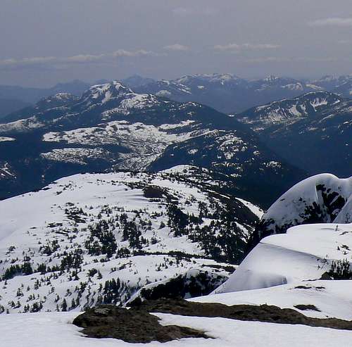
On the northwest axis that generally delineates the alpine spine of the Island, Mt Whymper lies ~ 26 km to the southeast and Mt Arrowsmith ~ 15 km to the northwest. Both are in plain view from the summit on a clear day.
The principle attraction of Moriarty is the lovely 2 km long alpine ridge walk from the last trees to the summit and the views that accompany the hiker the whole way.
I wish I could report that Moriarty’s name has something to do with Sherlock Holmes’ professorial arch nemesis. Nothing so fanciful I’m afraid. The mountain is named for William Moriarty, a lieutenant on the HMS Plumper, a British naval vessel that was very prominent in the exploration and early development of Vancouver Island.
Mt Moriarty summit
Getting There/Approach
Vancouver Island can be reached directly by air from Toronto, Vancouver, Seattle, Calgary, Edmonton and recently from San Francisco to either Victoria, Nanaimo, Comox or Campbell River and by ferry from Port Angeles to Victoria on The Coho and on BC Ferries from Vancouver to Victoria or Nanaimo. Public transport on the Island is notoriously poor and anyone arriving by air would be advised to rent a car.Access in this case requires the use of main line gravel logging roads. These are almost always negotiable in a normal 2WD sedan. Some sections may be rough so if you have access to a high-slung 4WD, bring it.
From the Island Highway 19 near Qualicum or Parksville, take Highway 4 west towards Port Alberni. Drive along the south shore of Cameron Lake, through Cathedral Grove Provincial Park and over the low pass, Alberni Summit. Just west of Alberni Summit watch for a left turn onto gravel and signed “The Connector”. Set your odometer to 0 here. You are on Summit Main. Drive down Summit approximately 2.5 km to its junction with Cameron Main and turn left. Proceed along Cameron for several kilometers until it crosses the Cameron River. 10.5 Km from highway 4 go straight on at the junction of Cameron Main with Pass Main – the access road for most routes on Mt Arrowsmith. Proceed on the main line 23.5 km from pavement to the vicinity of N49 07.910 W124 27.771 where the trail used to start. Island Timberlands have since logged the area and proceeding on the old trail via Labour Day Lake involves negotiating nasty logging slash. Instead proceed for a further ~ 1 km uphill and almost to the end of the road and start the hike from there. This new approach information is provided by Lizzie.
Route
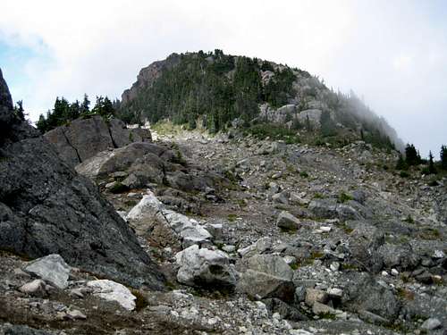
From the new trailhead head up through the forest on the steep but well worn boot track.It’s an hour or so of steady climbing almost due east before the trees start to thin out and the angle eases. At N49 07.656 W124 26.582 and 1,280 metres elevation you reach an important junction where the tendency is to keep straight on. Instead turn left (ie continue east) and make one more steep climb up and out onto the open alpine ridge at about 1,450 metres elevation. You will note the track direction swing to the north as you approach the ridge crest.
 Forest approach Forest approach |  Lower S ridge Lower S ridge |  Bluffs on the S ridge Bluffs on the S ridge |  Open alpine hiking Open alpine hiking |
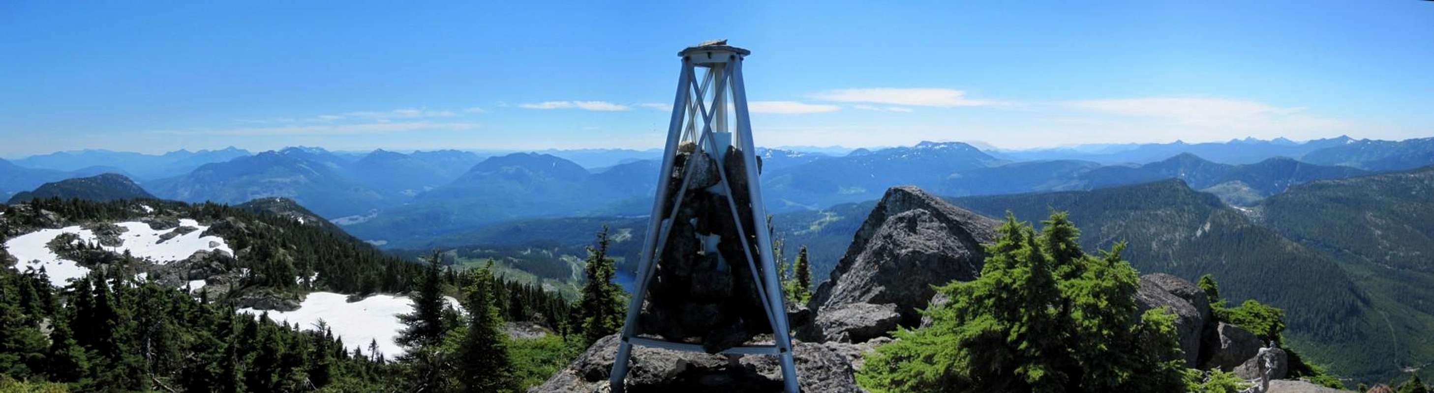
Once on the ridge follow the track north and then northwest through wonderful open terrain for a further hour or so to the little summit block with its hydrographic survey tripod. There is a well thumbed Alpine Club of Canada summit register to browse through and sign and, if the weather cooperates, excellent views of the central Island mountains and even the east coast towns along the Strait of Georgia to enjoy.
  |
Red Tape & Safety Considerations
You are outside any park and there are no fees to pay. Since you are on your own, essentially outside of any formal jurisdiction, it would be prudent to have left a detailed trip plan with someone responsible. The RCMP and the appropriate SAR agency will respond in an emergency but it is up to you to have the mechanism in place that will initiate call out.Camping
At 4-5 hours return, Moriarty is a day trip for almost anyone of reasonable fitness. However, if you enjoy camping for its own sake, just about anywhere on the ridge crest would be a great place to put up a tent. There is no restriction on camping that I am aware of and there’s water available everywhere. However, giardia is well documented throughout Vancouver Island, so boil or treat all water. Pack a small stove for cooking and definitely don’t light campfires. And, as always, be aware that bear and cougar frequent the mountains and forests of Vancouver Island. Proper back country methods – hanging food bags out of reach, cleaning up all cooking scraps, good toilet practice etc – are all absolutely essential.Additional Information/Suggested Reading
For more route information refer to Island Alpine – A Guide to The Mountains of Strathcona Park and Vancouver Island, Philip Stone, Wild Isle Publications, 2003, ISBN 0-9680766-5-3For precise directions get hold of a copy of Backroad Mapbook. Volume III: Vancouver Island
Weather
Nearest point current weather and forecast: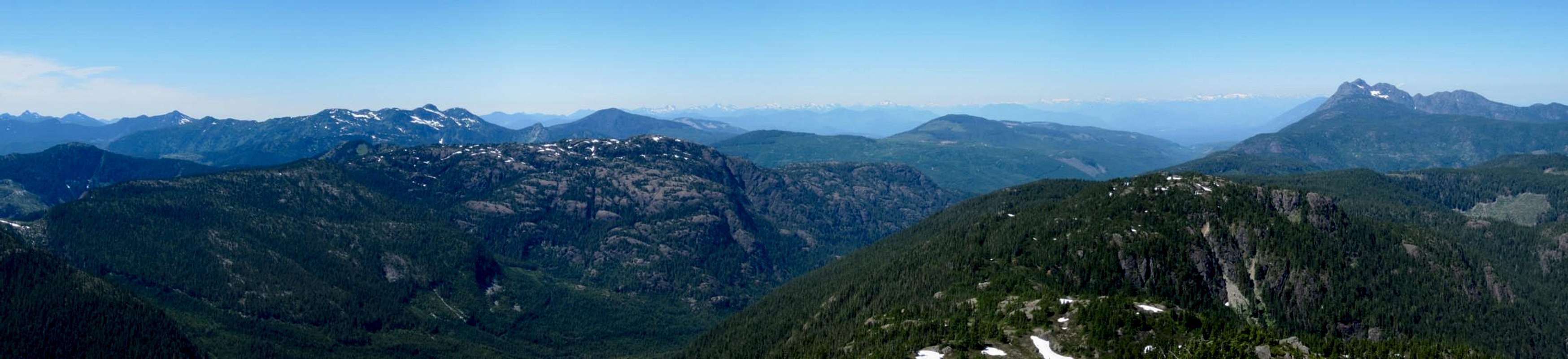 |
Jmoore - Oct 10, 2019 8:33 am - Hasn't voted
**getting there update*****Just After km 27 the road forks. Cam main is the one on the left, there is an open red gate, flagging dangling from trees and a tree with red/pink spray paint indicating the road name. *** the new trail up the slash is super booted in *** the whole trail including the new section is flagged in a combo of blue, pink, and orange tape.