
-
 70703 Hits
-
 79.78% Score
-
 11 Votes
|
|
Mountain/Rock |
|---|---|
|
|
16.62300°N / 120.89900°E |
|
|
Hiking |
|
|
9587 ft / 2922 m |
|
|
Topographic isolation: 650 km
Prominence: 2922 m
Overview
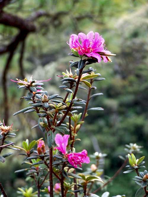
Flower on the mountain
Mount Pulag (or sometimes Mount Pulog) is the third highest mountain in the Philippines. It is Luzon’s highest peak at 2,922 meters above sea level, and it’s only some meters lower than the highest peak of the Philippines – Mt. Apo (2954 m). The borders between the provinces of Benguet, Ifugao, and Nueva Vizcaya meet at the mountain's peak.
Because of its high elevation, the climate on Mt. Pulag is temperate with rains predominating the whole year. Rainfall on the mountain averages 4,489 mm yearly with August being the wettest month with an average rainfall of 1,135 mm.
The mountain hosts 528 documented plant species. It is the natural habitat of the endemic dwarf bamboo, (Yushania niitakayamensis) and the Benguet pine (Pinus insularis). Among its native wildlife are 33 bird species and several threatened mammals such as Philippine deer, giant bushy-tailed cloud rat, “bowet,” and long-haired fruit bat. Mt. Pulag is the only place that hosts the 4 cloud rat species. It has one of the most diverse biodiversity of the Philippines, with the newly found (since 1896) 185 grams dwarf cloud rat, Carpomys melanurus, a rare breed (endemic to the Cordillera) and the Koch pitta bird among its endangered denizens.
A large part of the mountain is designated as a National Park. The aim is to preserve the environment around the mountain due to threats from increased development such as conversion to agricultural lands, timber production, hunting, and increased tourism.
The indigenous people of Benguet consider the mountain to be a sacred place.
Information about the National Park

Orientation in the Visitors' Centre
All visitors are required to secure permit from Mt. Pulag National Park Protected Area Office at Ambangeg,Daclan, Bokod, Benguet. Early coordination could also be made at the Protected Area and Wildlife Division, DENR-CAR Regional Office and CENRO Baguio.
All visitors are required to undergo an orientation/briefing at the visitor’s center/protected Area Office. It takes approximately 2 hours. Without this it’s not allowed to enter the National Park.

"Campsite 3"
Camping is allowed only in designated camp sites. Building of fire is strictly prohibited. Note that visitors should bring their own camping stoves and cooking utensils. Building of fire is strictly prohibited. Note that visitors should bring their own camping stoves and cooking utensils. All visitors shall keep the park area clean and sanitary at all times. Visitors shall be responsible to bring their own trash and garbage whenever they leave the park area, garbage and other refuse that can not be packed out shall be disposed off properly. All visitors shall use designated urinal and toilet areas to maintain sanitation in the park area.
Entrance fee:
a. Non-Philippine residents - US$ 15.00/person or its Peso Equivalent
b. Philippine Residents - P100.00/person
Camping fee:
a. Non-Philippine residents - P50.00/person/day
b. Philippine residents - P50.00/person/day
Green tax:
Philippine/Non-Philippine Residents - P25.00/person
Senior citizens above 60 years old shall also be exempted from paying the above fees.
All visitors are required to seek the assistance of legitimate/licensed and trained tour guides. Standard fee is collected when employing tour guides.
Guide fees for 4 trails going up the peak:

Overview map of the Ambangeg Trail
A. Ranger Station - Grassland (Ambengeg Trail)
| No. of tour guides | No. of visitors | Fee in PHP | Duration of stay |
| 1 | 1-7 | 500.00 | 2 days/1 night |
| 1 | 8 | 800.00 | 2 days/1 night |
| 1 | 9 | 900.00 | 2 days/1 night |
| 1 | 10 | 1000.00 | 2 days/1 night |
| 2 | 11 | 1100.00 | 2 days/1 night |
| 2 | 12 | 1200.00 | 2 days/1 night |
| 2 | 13 | 1300.00 | 2 days/1 night |
| 2 | 14 | 1400.00 | 2 days/1 night |
| 2 | 15 | 1500.00 | 2 days/1 night |
| 2 | 16 | 1600.00 | 2 days/1 night |
| 2 | 17 | 1700.00 | 2 days/1 night |
| 2 | 18 | 1800.00 | 2 days/1 night |
| 2 | 19 | 1900.00 | 2 days/1 night |
| 2 | 20 | 2000.00 | 2 dyas/1 night |
B. Akiki Trail
| No. of tour guides | No. of visitors | Fee in PHP | Duration of stay |
| 1 | 1-7 | 1800.00 | Ranger Station - Grassland - Akiki, 2 nights |
| 1 | 1-7 | 1800.00 | Akiki - Grassland - Ranger Station, 2 nights |
| 1 | 1-7 | 3000.00 | Akiki - Grassland - Akiki, 3 nights |
| 1 | 8 | 1600.00 | Ranger Station - Grassland - Akiki, 3 nights |
C. Ballay – Tawangan - Grassland
| No. of tour guides | No. of visitors | Fee in PHP | Duration of stay |
| 1 |
1-7 |
2500.00 3000.00 |
3 days/2 nights 4 days/3 nights |
| 1 |
8 |
2600.00 3100.00 |
3 days/2 nights 4 days/3 nights |
| 1 |
9 |
2700.00 3200.00 |
3 days/2 nights 4 days/3 nights |
| 1 |
10 |
2800.00 3300.00 |
3 days/2 nights 4 days/3 nights |
D. Grassland - Tinoc (via Tawangan)
| No. of tour guides | No. of visitors | Fee in PHP | Duration of stay |
| 1 | 1-7 | 2500.00 | 3 days/2 nights |
E. Balete, Kayapa - Ranger Station - Grassland
| No. of tour guides | No. of visitors | Fee in PHP | Duration of stay |
| 1 | 1-7 | 2500.00 | 3 days/2 nights |
A local guide
Ranger Station-Grassland: 250.00 PHP
Ambangeg - Ranger Station: 400.00 PHP
Akiki Jump off - Grassland: 1,200.00 PHP
Ballay - Tawangan - Grassland: 2,500.00-3,000.00 PHP
Grassland - Ballay: 2,500.00-3,000.00 PHP
AMBANGEG-BABADAK ROUTE IS ADVISABLE TO AMATEUR CLIMBERS WHILE AKIKI TRAIL IS FOR CLIMBERS in better condition.
DURING THE COLDEST MONTHS, THE GRASSLAND AND BABADAK AREA EXPERIENCE FROST THUS ALL VISITORS/CLIMBERS MUST COME WITH PROPER CLOTHING.
CLIMBERS MUST PROVIDE THEIR OWN CAMPING GEARS, COOK SET AND OTHER PROVISIONS. CAMP FIRE IS NOT ALLOWED IN THE PARK.
As for food provisions, you must bring some with you as their are limited goods near the park. Mini-stores are found near the Babadak Ranger Station. Bigger groups are advised to purchase in Baguio City as the stores cannot cater to bigger groups.Porter RatesPorter fees:
Getting There
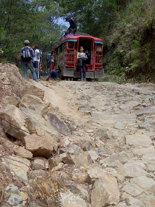
Our jeepney heading to the Ranger Station - but waiting with flat tires
Ranger Station – Grassland trail description
This is the most frequently used trail up to the peak.
Most hikers go to Mt. Pulag from Manila or from Baguio City. Going from Manila first you must get to Baguio City. The easiest way is to get an evening bus from Metro Manila, from the Victory Liner Bus Terminal in Cubao, EDSA. It’s advised to get an evening bus at 10 p.m. that will get to Baguio 6-6.5 hours later. There are buses to Baguio every hour. From Baguio you can get to Ambangeg with public buses or with rented jeepney.
Buses do not enter park. The road going to the Ranger Station is challengingly rough and leads consistently uphill and very narrow that we need well conditioned vehicles and experienced mountain drivers to traverse the road. The passengers need to hire vehicles from Ambangeg to Ranger Station but most of the vehicles in
the area are not well conditioned. At times there are no available vehicles during holidays.
During the peak season too, the buses cannot accommodate all visitors thus it’s advised bigger groups to hire vehicles in Baguio City who can fetch them from the terminal to the Ranger Station and fetch them again on their way home. In general it is complicated to use public transport to get from Baguio to Ambangeg. It really advised to hire jeepney for the trip. If the you are alone or in a too small group to pay the total hire fee of a jeepney, try to join a bigger hiking group in Baguio who already arranged the hire of a jeepney. In climbing season on Saturday early morning you can easily find such hikers at the Victory Liner Bus Terminal in Baguio City.
The round trip hire of jeepney ranges from P7500-P9000 depending on the load and number of passengers. The Ranger Station can accommodate about 15-20 persons depending on the time of your visits. Other visitors might use it too you must inform us if you want to sleep at the Ranger Station. You must also contribute for the maintenance and upkeep of the Station since most of the guides are the ones maintaining it.
The ranger station is in an approximate elevation of 2300-2350 m. The hiking starts from here. The distance from here up to the peak is not more than 9 km. The trail is well maintained. It’s just an easy walk to get to the peak. You may ask why is the tour is an overnight tour if it is so easy and not too long (2 x 9 km = 18 km)? If you do your hike as part of a Philippine hiking group, you must adopt to their speed. The Philippine hikers do not aim for doing high physical performance when hiking. Their goal is more to enjoy hiking as a social event and having fun together. Otherwise the Mt. Pulag hiking could be done in one day.
There are two campsites on this trail before the peak. Campsite 1 is too near to the ranger station, so it’s not so much used. Campsite 2 is approximately 2 km before the peak and it’s a favourite campsite. There is good fresh water source here. Campsite 3 is just under the peak – 1 km after the peak, in an approximate 2800 m elevation. It’s again a preferred campsite. All campsites are equipped with toilets.
Best season to climb
 Good weather today
November-March, in order to avoid the rainy season
On the Peak
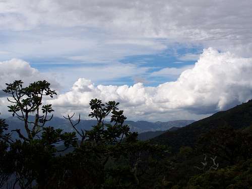
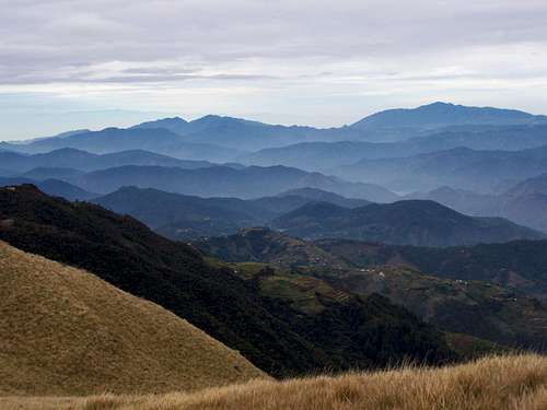 Wiew from the peak
The peak is the highest point of the Grassland Area. Just on the peak there is a small flat area that is usually overcrowded with hikers. There are some bushes on the peak and it can protect people from the generally strong wind. In clear wether the panoramic view of magnificient. In NW direction you can see the nearby Mamuyud (2840 m) - it is only 600 meter far from Pulag. Also in NW direction you can see Mt. Singakalsa (2688 m) in 14 km distance, and Mt. Tabayoc (2812 m) in north.
mtbaxter - Jun 13, 2013 9:32 pm - Hasn't voted
Error re rank in elevationPulag is actually the third, not the second highest mountain in the Philippines. Both Apo (2954 M) and Dulang-Dulang (2938 M) are higher than Pulag (2922 M) Dulang-Dulang is usually referred to as "D2" by the Philippine climbing community. Both Apo and D-2 are in Mindanao Island, but in separate ranges. Last year I attempted the four highest (includes Kitanglad, also in Mindanao) but missed D-2, while my climbing companion Bob Packard succeeded, but missed Kitanglad. Our climbing group split into two, one on D2, the other Kitanglad
SzaniUherkovich - Jun 14, 2013 4:19 am - Hasn't voted
Re: Error re rank in elevationThanks for the info. I updated the page
SzaniUherkovich - Jun 14, 2013 3:06 pm - Hasn't voted
Re: Error re rank in elevationWhy don't you log the Climber's Log?