
|
|
Custom Object |
|---|---|
|
|
Custom Object |
Overview
PAGE JUST ADOPTED, WILL BE COMPLETELY REWRITTENVery popular climbing mountain in Tatra Mts. The easiest route is II. The hardest are more than VII.
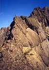
The hardest routes are these on the S face - see the picture.
First ascent: Jozef Bajer, Ignacy Krol, Ludwik Pregowski, 9 VIII 1904.
First winter ascent: Jozef Lesiecki, Leon Loria, Mariusz Zaruski, Stanislaw Zdyb, 1 IV 1911.
 |  |  |  |  |
Red Tape
This is a National Park (Polish and Slovakian), so there are some strict rules of wildlife conservation (there are informations in Polish, German and English with lists of interdictions). No fauna and flora can be disturbed or collected.Entry charge to the Park is about 0.50 US$. per day.
When to climb
The best wheather is on August - September, or, during the winter January-March, which depends on the snow conditions. On June - July frequent t-storms.Camping
There is a camp site of Polish Mountaineering Ass., near the road from Chalet to Brzeziny. There are many camp sites in Zakopane. Climbers may also use the Chalet ( as I know, the price for the bed oscillates between 7 and 13 US$), or "Betlejemka" refuge, 5 min from the "Murowaniec" chalet.Links and informations
Zakopane Online- in english
(+48)(18) 20-15-560; 20-14-731 - Tatra Volunteer Rescue, they also have a site, but only in Polish:
TOPR - Tatra Volunteer Rescue
Chalet in Dolina Gasienicowa- (+48 18) 20 126 33
Chalet in Dolina Pieciu Stawow- (+48 18) 20 776 07
Books
Zamarla Turnia is described in vol. II of the guide "Tatry Wysokie" written by W. H. Paryski (reedited by Sklep podroznika, 1992; there is no ISBN).There is also short guide written by A. Sklodowski & M. Woloszynski "Zamarla Turnia" edited by PTTK-Kraj, 1992
ISBN 83-7005-329-7
Very high quality (and cheap) Slovakian maps edited by VKU - website in Slovak only.
Getting there
From Cracow (Southern Poland) go to Zakopane (by train (today it is about 20 US$), or by coach(about 4 US$)). From Zakopane take a bus to1. Kuznice. Now follow yellow or blue tourist marks (both go to Hala Gasienicowa, i think faster is blue-marked one). From Chalet "Murowaniec"(here first cross-roads), still follow the blue marks (go to Czarny Staw [The Black Lake], second cross-roads)), and then to Zawrat (Pass, 2159 m asl). After about 45 minutes you will reach the third cross roads. Yellow marks goes to Kozia Przelecz - follow them, and after 25 minutes You will reach northern slopes of Zamarla Turnia
2. From Zakopane take a bus to Morskie Oko. From the end of the route You have to walk about 4 km, untill You reach Wodogrzmoty Mickiewicza (Mickiewicz's waterfalls). Than take green marks to Dolina Pieciu Stawow Polskich (The Valley of Five Polish Lakes). Through the forests of Roztoka Valley go about 1.15 h. There is a cross-roads. Black marks go stright to the Chalet (faster, 30 min.), the green goes to the Chalet, but through Siklawa, the biggest waterfall in Tatra Mts. (45-50 min.).
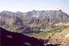
Look for the signs showing the way to the Kozia Przelecz (blue and yellow marks). After ca. 1 h. you will reach Pusta Dolinka (Empty Valley). South face of Zamarla Turnia is seen.
 |
Overview
Zamarła Turnia is one of several peaks in the ridge that branches off Świnica in the main ridge of the High Tatras. Its name was coined by a Polish poet and climber Franciszek Henryk Nowicki and means 'Lifeless Spire' or 'Lifeless Peak', as turnia, literally meaning 'spire', is often used in the Tatras in names of many less significant peaks independently of their shape. Its first known ascent was on 9 August 1904 by Józef Bajer, Ignacy Król and Ludwik Pręgowski.
|


Although it is neither among the highest nor the most prominent summits, it holds a special place in the history of Polish climbing. Its south face, although relatively not too high (140 m), thanks to its spectacular, smooth granite slabs is unique compared to the rest of the Tatras. After numerous previous attempts it was finally climbed on 23 July 1910 by Henryk Bednarski, Józef Lesiecki, Leon Loria and Stanisław Zdyb. Their route, so-called 'Classical', is graded V UIAA. Sadly, the famous face has also been the scene of many climbing accidents, not least due to the myth that has always surrounded it and later on because of its popularity. Nowadays the south face has numerous climbing routes of various degrees of difficulty.
|

Getting there
The nearest neighbours of Zamarła Turnia are Mały Kozi Wierch to the west (separated by the col Zmarzła Przełęcz) and Kozie Czuby to the east (separated by Kozia Przełęcz). The summit is easily accessible (a scramble graded I UIAA or class 3 YDS) from the Orla Perć (Eagle Path) red-marked trail but the trail only crosses the terraces north of the summit. According to the National Park rules leaving the marked trail is forbidden if you are not a climber.In the neighbourgood of Zamarła Turnia, Orla Perć goes from Zmarzła Przełęcz to Kozia Przełęcz. The latter can be reached via marked trails from both sides of the ridge.
From the north (Murowaniec hut): blue, then yellow, 2-2.5 h.
From the south (Pięć Stawów Polskich/Five Polish Lakes hut): blue, then yellow, about 1.5 h.
The blue trail crosses the Zawrat pass to the west. From Zawrat to Kozia Przełęcz it takes about 1.5 h via red-marked Orla Perć.
In the ridge area all the above trails, especially Orla Perć, have plenty of ferrata-style aids - chains, railings, ladders, pegs etc. However, they are NOT fully fledged via ferratas and cannot be climbed with a harness and slings.
map
To reach the bottom of the south face you have to go to a little glacial valley below it, called Pusta Dolinka (Empty Valley). It can be reached as it was mentioned above: blue, then yellow marks from Five Polish Lakes, or crossing Kozia Przełęcz to descend south if you approach from Murowaniec.
Accommodation and camping
The nearest place to sleep is the hut at Five Polish Lakes, with staffed kitchen serving hot and cold meals and drinks. It tends to get very crowded in summer. Sleeping on the floor, on tables, benches etc. is possible and very common in high season, to the degree that the hut gets totally crammed. Sometimes it may be possible to sleep at the nearby park rangers' hut if the rangers agree. In Pusta Dolinka there are a few natural shelters under large boulders which can be used for sleeping, some are really well hidden and even nicely protected from rain. Such a shelter is called koleba. Wild camping is forbidden in the National Park so I do not recommend this practice, only inform ;-) If you sleep there, keep a low profile and leave no trace! When I was there in 1997 we did not observe any particular ranger activity aimed at fining the camping climbers but this is not the rule.
|

Red tape
National park rules apply. Leaving marked trails is forbidden unless you are a climber on the approach to a route or descending after a climb. As mentioned above, camping is oficially forbidden.Routes overview
left hand side topohttp://www.kwtorun.pl/index.php?page=topo&topoId=3&photoId=3
click on the topo to expand
right hand side topo
http://www.kw.warszawa.pl/topo/zamarla_turnia/f/sciana_pdwschodnia_15_drog
ZAMARŁA TURNIA
Była celem pracy społeczników z akcji Tatry Bez Młotka. A jest to trudna praca – kawał podejścia, logistyka jest niełatwa, no i brak chętnych rąk do pomocy.
„Kierownikiem” prac był Artur Paszczak, który wraz z Krzysztofem Korne dokończył rozmieszczanie nowych przelotów na Drodze Motyki V.
Słyszałem wiele opinii na temat prac na Zamarłej, jakoby wybijano haki i nie dobijano
nic w zamian, jakoby drogi, w tym Motyka, posiadały niewystarczającą stałą asekurację i by je przejść bezpiecznie, niezbędne jest posiadanie jakichś wyrafinowanie małych mechaników. Nie widziałem, więc nie chciałem zabierać głosu w tej dyskusji. Jednak w tym roku wspinałem się tam wraz z swym kursem i początkujący taternik, z podstawowym „betlejemkowym” sprzętem, przebiegł przez tę drogę szybko i bezpiecznie. Akurat miało to miejsce w dniu, w którym Artur dobił jeszcze dwa spity, o które prosili go instruktorzy. W tym momencie droga jest już bardzo bezpieczna. Trzeba jednak pamiętać, iż do jej przejścia nie wystarczy komplet ekspresów. Po prostu trzeba mieć ze sobą zestaw kostek i parę średnich i małych friendów.
Ale na tym właśnie polega wspinanie na własnej asekuracji, a nie na wpinaniu się w stałe stare haki (często fatalnej jakości). Teraz parę słów do tych, którzy oburzają się, że na takich klasykach pojawiają się czasami spity. Mogę się założyć z każdym, iż trudniejsze będzie przejście wyciągu, na którym jest jeden lub dwa spity, między którymi trzeba założyć z dziesięć własnych przelotów, niż przejście tego samego wyciągu, na którym osadzonych jest dwanaście starych haków...
Czasami wydaje mi się, że to jest największy problem dla tych, którzy najgłośniej narzekają. Zamiast odwoływać się do „zaspitowywania klasyków”, proponuję, całkiem niezłośliwie, więcej się wspinać i podnosić tym samym swój poziom.
W trakcie wakacji, podczas szkoleń instruktorzy z Betlejemki w ramach akcji nTatry Bez Młotka osadzili po jednym spicie na stanowiskach z Festiwalu Granitu, a także wybili stare i osadzili nowe haki na trawersie i zacięciu wyjściowym. Więcej o akcji TBM przeczytacie na s. 54–55 (GÓRY, 186 / 2009).
http://www.goryonline.com/Sezon_letni_w_Tatrach_Wysokich_lato_2009,7416,150,0,0,F,news.html
Tatry bez mlotka opis i topo 2009
http://www.wspinanie.pl/serwis/200908/05tatry-bez-mlotka-zamarla-turnia.php
|

Egzamin z fizyki VII- (6b) Half a day
You can approach the bottom of the wall both from Murowaniec shelter or Dolina 5 Stawow Polskich (5 Polish Lakes Valley) shelter.
Wariants to Zyga and Mu-Mu-Mu, first climbed by M. Nieciecki and M. Tertelis in 1989.
Take a set of friends, runners and narrow pittons.
Trawers V+ Half a day
2 hrs from Murowaniec. The easiest way is to follow the red marks (Orla Perc) and reach Zmarzla Przelecz (The Frozen Pass). The route starts from here.
Helmet! Be prepared for sudden weather changes!
Zyga VII (6b) Half a day
You can approach the bottom of the wall both from Murowaniec shelter or Dolina 5 Stawow Polskich (5 Polish Lakes Valley) shelter.
Excellent slabby route, first climbed by M. Nieciecki and M. Tertelis in 1989.
Part of pitches are equipped with bolts. On other a standard set of friends, runners and even a few narrow pittons should help :).
Warianty klasyczne VI Less than two hours
You can approach the bottom of the wall both from Murowaniec shelter or Dolina 5 Stawow Polskich (5 Polish Lakes Valley) shelter.
Take a sety of friends and runners.
Lewi Wrześniacy V Half a day
2:30 from Murowanie
In the middle there is a V+ variant which is quite interesting, since it goes straight under a big overhanging
Helmet, nuts
Mu-Mu-Mu VII+ (6c) Half a day
You can approach the bottom of the wall both from Murowaniec shelter or Dolina 5 Stawow Polskich (5 Polish Lakes Valley) shelter.
Excellent slabby route with a crux in overhang, first climbed by P. Federak and M. Tertelis in 1998.
Route equipped with bolts, although a standard set of friends might help :).