
|
|
Mountain/Rock |
|---|---|
|
|
33.08410°N / 131.25000°E |
|
|
Oita |
|
|
Hiking |
|
|
5876 ft / 1791 m |
|
|
Overview
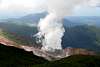
 Kuju lavadome with fumarole
In the Northeast of the third largest Japanese island Kyushu the Aso-Kuju National park protects the mountain areas of two active volcanoes. Due to its location surrounded by grassy highlands, Kuju's (九重山) forests, meadows and mountains attract a large number of nature enthusiasts. Especially the season bloom in spring changes the whole area into a giant natural garden. The Kuju area is also famous among Onsen (hot spring) lovers for the vast number of hot pools in the area. The most famous Onsen resorts among others are Kurokawa-onsen, Yufuin and Beppu. Therefore the area makes for a fine combination of hiking and relaxing in one weekend.
 On the summit
The name Nakadake (中岳) means central summit in Japanese and is a perfect explanation for its position in the Kuju massif. With 1791m Nakadake is the highest peak of Kyushu. A climb of the summit can easily be combined with a traverse of some other peaks in the area as for example the close neighbors Kuju-san (久住山) (1787m) or Hossho-san (星生山) (1762m). In a clear day the summit view offers an excellent outlook on the heavily steaming fumarole of Hossho-san just 1 km apart and the other rocky and green Kuju peaks. To the South one can oversee the giant Aso caldera with Aso-san (1592m) at the horizon. To the Northeast the double cone Yufu-dake (1584m) should be visible.
Be aware that Mount Kuju is an volcanically active area since the two centuries sleeping volcano awakened in 1995 again. Currently (Apr 2009) only strong fumarolic activity is observed and the access to the area is not restricted - except to the active lavadome itself.
 |
 |
 |
Getting There
 Nakadake from Kuju-san
Kuju is located between the cities Kumamoto and Oita. The Oita expressway offers excellent access by car from these cities and Fukuoka.
From Fukuoka, Kyushus largest city, the fastest public transport is by Japan Rail (JR). Take the "Yufuin-no-mori" limited express train from Hakata (Fukuokas main station) until Bungonakamura station (豊後中村駅) (2 hrs). There is a bus from the train station to the trail head from spring to fall. Take the Nishitetsu bus towards Makinoto-toge (牧ノ戸峠) and get off at Choja-bara (長者原) (50 min).
There are also several other possible routes. As there is also a bus connecting Beppu with Kumamoto the whole year around and stopping at Makinoto-toge.
Routes
 Hiking trails
Due to its central location within the Kuju massif and the extensive network of hiking trails, Nakadake can be climbed from all directions.
From Choja-bara via Bogatsuru:
From the starting point at the parking lot of Choja-bara head to the east crossing a field of Susuki grass towards the forested slopes. Before entering the forest you should pass a at least one wooden sign directing to Bogatsuru - just to be sure since an network of trails makes orientation a little difficult. Now the trail winds up in the forest along a valley. Just follow the main trail and after about 90 min you will pass the open meadows of Ama-ga-ike. At the end of the plateau you will habe a nice outlook on the Bogatsuru valley with Taisenzan (大船山)(1786m). Descend on the trail into the valley, where a small unpaved road leads you to the Bogatsuru campground (2.5 to 3.5 hrs). You can stay here and do a side trip to Taisenzan or continue to the small group of houses of Hokke-in. Try to find the sign for Nakadake in front of the private cabins the marks the trail for a straight one hour climb of Nakadake.
 Kuju plateau
If you don't find the trail you can follow the frequently used path approaching the valley to the East beside the river. Climb in 30 min to a large plateau and you will join with the direct route from Choja-bara.
Direct from Choja-bara:
Follow a small paved road for about 2 km winding up to the smoking lava dome of Hossho-san. The road leads to a research station of volcanologists. At the end of the road a trail starts that climbs into a col with a protection shelter. From here walk down to the plateau and follow the trail South. After crossing the plateau passing the steaming slopes of Hossho-san you start climbing a ridge that connects the highest summits of the Kuju massif. On the ridge follow the path signs directing to Nakadake to the East. Be aware that clouds can come in very fast and may complicate orientation. Following the trail on the ridge you will pass some green funnel like volcanic craters and a small turquoise mountain lake. Nakadake is the highest point east of the lake. There was also a small shelter beside the lake, but it is in poor condition and barred.
Red Tape
 Steaming lavadome
The mountain is located in a National Park which should remind you to be even more responsible as usual. Currently (Apr 2009) there are no general restrictions for entering the area, but keep in mind that you hike in the area of an active volcano and the conditions can change fast. Some trails pass the active region very close and marks clearly show the prohibited zone.
Please use the corresponding links to inform yourself about current volcanic activity. This information will not be updated frequently.
Camping
Camping is allowed at the free Bogatsuru camp ground. There are toilets and drinking water is available. The hut some 100 meters beside the ground is in bad conditions and should be considered as an emergency shelter only. Another (but not free) campground is available about 20 min from Bogatsuru at Hokke-in. At Hokke-in a small Onsen offers a hot bath after the hiking day. Bongatsuru campground with Nakadake
Literature
Lonely Planet "Hiking in Japan"ISBN 1-86450-039-5
External Links
Excellent topographic online maps covering whole Japan and the corresponding map of NakadakeJapanese mountain database
Short article on Kuju on Hiking in Japan
Timetables:
for trains on hypedia or the JR Kyushu website and for Hita bus (in Japanese only)
Weather forecast of Japan Meteorological Agency
Up-to-date information about volcanic activity in Japan from Geological Survey of Japan
Two websites about the 1995 eruption: from AIST and Tatsuro Chiba