
|
|
Mountain/Rock |
|---|---|
|
|
30.24009°N / 120.12108°E |
|
|
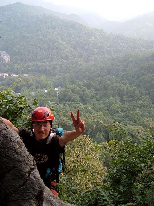
Hiking, Sport Climbing |
|
|
Spring, Summer, Fall, Winter |
|
|
820 ft / 250 m |
|
|
Overview
This low mountain is set amidst terraced tea fields which rise very near to the summit. It's located just outside of Hangzhou, a popular Chinese city more well known for the serene West Lake (Xi Hu), its history as the Chinese capital from 1127-1279 AD, and locally made tea and silk. The high perch also offers some dramatic views of West Lake and the
The mountain is within the bounds of the West Lake National Scenic Area. The slopes are crisscrossed with stone-laid paths and there are several dirt paths that may qualify as trails depending upon your personal definition. The summit has a very authentic-looking pagoda which was visited by Chairman Mao. In more recent times, an informal group of taichi enthusiasts visits the summit nearly every summer morning approximately 20 minutes after sunrise. Newcomers welcome!
Red Tape
There’s not much red tape. Sometimes the locals block off the road to the parking area and charge a parking fee of 20 RMB. If you don’t feel like paying, you may be able to negotiate or you might park along the main road and walk an extra 100m.If you are driving from Shanghai, there are several toll booths along the way. Driving time can vary from 2.5 hours to over 5 hours. The traffic is often backed up along the entire route. Bus and train transportation is possible but this will leave you in Hangzhou proper, still a 10 minute drive from the crag.
Camping
There isn't much agreeable camping. First of all, camping isn’t much of a recognized hobby in China. Any passerby who sees you will have a strong curiosity to investigate what you are doing. So obviously don’t leave an unguarded tent. Second, the ground is densely overgrown with very little flat ground. However, if you aren’t too picky you may find some ground that is flat and clean enough to pitch a tent but it is advised to pack up as soon as dawn breaks. I've camped near the pagoda and there is also potential near the lower wall but only for 1-2 tents.Climbing
Upper Wall
The upper wall has 5 bolted lines. The climbing is very easy to see from one of the main trails in the area. Most weekends there are several local climbers hanging out. From the main parking lot, head up the trail and make the first left, take it to the top of the hill, then take the next right, soon you will pass the wall on left hand side.
1. (Far Left): 5.9 (?), short crack and stemming problem, traverses right and shares an anchor with the neighboring route
2. (2nd from Left): 5.11c (?), can be toproped after climbing the previous route or lead
3. (3rd from Left): 5.10c (?), nicely exposed with a low crux, climbing gradually gets easier towards the top
4. There might be a 5.12b here that shares an anchor with route 3 or 5.
5. (4th from Left): 5.10b (?)
6 and 7. (5th from Left): 5.8- (?), a small roof leads to either an easy crack on the left or face climbing on the right. Keeping to the left of the bolts makes the route 5.8. Right of the bolts is ~5.10a, the crux is getting over the steep roof at the start of the route.
The lower wall has 4 bolted lines, the left-most of which is reached by passing through a short cave and down climbing a 5m chimney (~5.6) or rapping (one bolt is available). Although this wall is a bit off the trail making it hard to find, you can see the tall cliff face through the trees. The easiest way to get there is to make a sharp left turn off the main trail just before passing another trail that descends into a wide mouth cave. The trail you want to take is faint and veers steeply uphill just before the opening of the cave and continues going uphill until you reach the cliff and then you should see some bolts if you look carefully. The top of the wall is easy to reach by descending a steep trail from the Upper Wall (then rap off the fixed anchor to the bottom of the wall).
8. (Far Left, through cave): 5.10d (?), steep face to a ledge, then easier face climbing and finish with a couple balancy moves
9. (2nd from Left, right side of cave entrance): 5.8 (?), follow the easy dihedral until it narrows, then find a couple solid finger holes and pull through to the top
10. (3rd from Left): 5.7 (?), This is the longest route at the crag, ~25m. This route is normally a little dirty
11. (4th from left): 5.6-5.7 (?)
External Links
http://www.farerdak.com/hike/Html/2007427215723-1.htmlMore information on rock climbing routes, although it is all in Mandarin and the YDS ratings are suspect.