
-
 8611 Hits
-
 79.78% Score
-
 11 Votes
|
|
Mountain/Rock |
|---|---|
|
|
16.90968°S / 177.39761°E |
|
|
Nacula Island |
|
|
Hiking |
|
|
781 ft / 238 m |
|
|
Overview
Neisau peak (238m) is located south of the village of Nacula on Nacula Island, Yasawa Island Group in the Republic of the Fiji Islands. While the peak is not high by any standards it provides a welcome hike, altitude fix and respite from water-related activities on Nacula and nearby islands. Neisau peak also provides a good sense of place in the Yasawa group as you can see up and down the island chain (from Yasawa island down to Naviti island) from Neisau's summit.Getting There
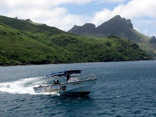
Aside from private floatplane or boat, the most practical way to get to Nacula island from the Fiji mainland (Viti Levu) is via the Yasawa Flyer. The Yasawa Flyer is a high-speed catamaran with daily service to the Yasawa group and is operated by Awsome Adentures Fiji. Once at the Nacula island stop, take the water taxi to Oarsman's Bay Lodge. It's about a 4.5 hour boat ride from Denarau port/Nadi to Nacula island.Note: Oarman's Bay Lodge is a Fijian-owed lodge that is a unique place. If you are lucky enough to have the local islanders sing to you during dinner this is a very special event and heart-warming experience. The music here is authentic, original and moving. The commercial cruise ship luau in Hawaii it's not. If you are asked to dance and sing along. You should join in. The opportunity to do this again may not come along again in awhile.
Routes
Go around to the back the main Oarsmans Bay Lodge building. Go past the generator shed and resort garden and follow the track up the hill. The track will pass a couple of water tanks and should be obvious all the way to the summit. The track forks after about a mile. Take the left hand track. The right hand track will take you to a lower satellite summit (worth visiting too).The length of the track from the resort to the Neisau summit is about two miles and the round trip takes about 2-3 hours.
Also: I spoke with a couple of locals at the resort and they had done an Nacula island traverse from Neisau summit to Ulunixoro (210m) to Xorobexwa (258m and the island's highest summit). They said that there wasn't a trail connecting the peaks. From the looks of it, it looked like a bushwack traverse, with some parts easier than others. It looked like an all-day affair, but doable. Ulunixoro summit looked the most interesting with rocky summit scrambling.
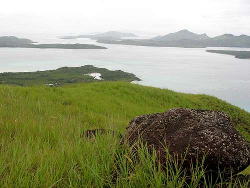
View south down the Yasawa Island chain from Neisau summit, Nacula Island, Fiji
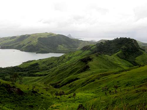
View north from Neisau summit
Camping
Camping is available at the Oarsmans Bay Lodge and most other lodges in the Yasawa group. See Red Tape section.Red Tape
A note about bandit camping/hiking in the Yasawa group: Native Land/Trust rights seem be taken pretty seriously in Fiji. The Western-style public park/public lands concept seems to be pretty foreign in Fiji. Even the designated national parks seem to be controlled by local villages/tribal groups. The native Fijians look upon the land as theirs and you are a permitted guest on their terms. It would seem wise to always ask permission from a village chief or elder (via a Sevusevu ceremony?) to hike or camp on native land if you are not with a local guide or approved group. This seems pretty strange but if you start adventuring in Fiji you will soon pick up on this. Rest assured though, the Fijian people are very friendly people. Once you get permission to land pass, you will be good to go.Additional Information
There doesn't seem to be any formal printed publication for hiking/climbing in Fiji. Here's some anecdotal info:Note: specialized Fiji maps are available for purchase here: http://www.lands.gov.fj/
Fiji Rucksack Club
Box 2394
Government Buildings
Suva, Fiji
https://sites.google.com/site/fijirucksackclub/about-us
Waya island possiblities:
Uluiwaya (or Kopoimatalevu?) (567m) on Waya island is the highest peak in the Yasawa group. There's a north-south track that cuts Waya island in half. The topo map I studied didn't indicate a track to the top. A bushwhack seemed possible, though getting some local information about any existing tracks up Uluiwaya would probably serve to prevent a tropical bivouac.
Additionally, The Octopus Resort has a local and guided trek up one of the lower summits on Waya island. This summit is the lower horn of the two horned summits that overlook Nalauwaki village and Bay.
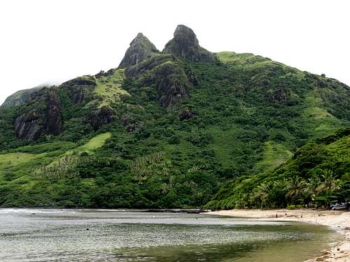
Peaks that overlook Nalauwaki village and Bay, Waya Island, Yasawa Group, Fiji
The track for the summits near the village of Nalauwaki begins at the beach just north of the village of Nalauwaki where the waterfall/river meets the sea. The track is very steep and rises about 400 meters abruptly.
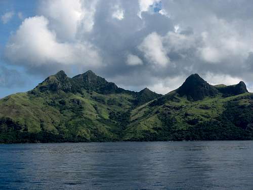
West side of Waya Island, Yasawa group, Fiji
Batinareba (510m) on Waya island has tracks to the top of this summit. The view from the ocean to this peak is pretty impressive. Moon Handbooks Fiji, 7th edition, David Stanley, pgs 242-243.
Batinareba peak, Waya Island, Yasawa group, Fiji
Topo map: Plans in the Yasawa Ilsands, Waya Group, Fiji Hydrographic Office. Published Dec 30, 1992. Scale: 1:25 620
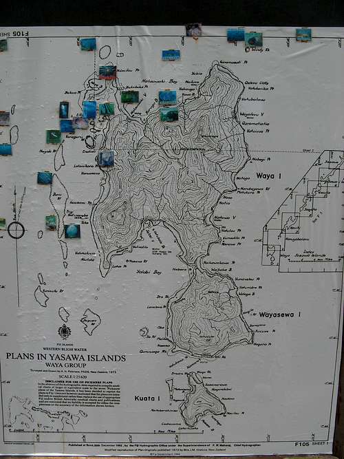
Waya Island map
Vitu Levu possiblities:
Fiji's highest peak
Tomanivi (Mount Victoria) 1,323m
Climb report by Burton "Kava Head" Falk
http://angeles.sierraclub.org/sps/archives/sps01662.htm
Also: http://tomanivi.com/ and info at Peakbagger.com
Also: Moon Handbooks Fiji, 7th edition, David Stanley, pg 225
Mount Batilamu (1,195m) in Koroyanitu National Heritage Park:
Info packet reviewed onsite at Stoney Creek Resort strongly suggested that access to Batilamu summit was by guided trek only (2 nights 3 days ~FD$360) A review of Fiji topo map for the Lautoka district showed two trails leading to the summit of Batilamu. One started in the village of Abaca, the other started in Navilawa (across the range). Cursory web searches suggest that Abaca would be the better starting point for this trek as it seems to be the entrance to this national park.
Moon Handbooks Fiji, 7th edition, David Stanley, pgs 234-235
also: http://www.exquisitefiji.com/viti-levu/viti-levu-highlands/koroyanitu-national-heritage-park/
http://www.batilamutrek.com/
Summary/Additional Links
Hiking in the Yasawa Island (trip report by SP member BLong)Neisau Peak trip report from Naturalbornhikers.com (excellent photos)
Yasawa Islands at Wikipedia
http://www.awesomefiji.com/default.aspx
http://oarsmanbayfiji.com/
Other lodges in the Yasawa Ilsands group
http://www.lands.gov.fj/
Fiji Rucksack Club Facebook and webpage
http://moon.com/books/moon-fiji/
http://riversfiji.com/
Rock climbing in Fiji?
Further reading:
Hill Tribes of Fiji by A.B. Brewster
https://archive.org/details/hilltribesoffiji00brew
Amazon.com ebook link
Goodreads.com Popular books on Fiji
Amazon.com's Fiji Travel Guides Best Sellers
Mutiny on the Bounty
Music of the Fiji Islands Bula baby!