
-
 7341 Hits
-
 74.01% Score
-
 4 Votes
|
|
Route |
|---|---|
|
|
24.933°S / 66.383°W |
|
|
Mountaineering |
|
|
Spring, Winter |
|
|
Expedition |
|
|
D |
|
|
Overview
Cachi lies South-West from Salta, Argentina.It's altitude is assumed to be 6380 m.
Even if it seems an easy climb on paper, consider this region to be one of the most unstable micro-climate of Argentina. In fact you are in a wetter region and the best period to climb is october-november. Every day from january to april you have fog coming up from the valley and it's quite easy to loose path.
 Fog coming up from the valley when we came back from summit.
A daily storm is to plan between 5-6 PM
In case of accident, rescue may take a few days to come as the police station in caci village isn't equiped with safety gears.
Getting There
To get to Cachi village drive South from Salta to El Carril and then take the provincial road going to Payogasta.The road goes throug a steep valley which is sometimes unaccessible during rain seasons. It's possible that you will be able to come to Cachi but that you have to wait to go back if the road is in bad condition.
 Route from Salta to Cachi
There is a bus service from Cachi village to las Pailas but it's not operating every day. It's probably better to find a transporter (Taxi) and to fix with the driver the returning date so he will come to las Pailas to catch you (don't pay the whole amount but only the one-way price firts. If not, you risk the driver will never come to Las Pailas when you come back from the mountain).
 Quebrada de los Arcas from Las Pailas
Route to the high camp
 Route to Cachi high camp
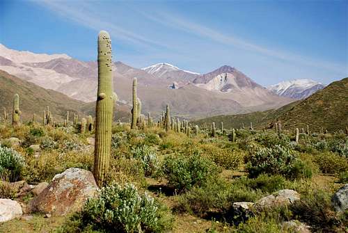
From Cachi you will be able to drive some more kilometers to Las Pailas where you can leave your car somewhere between the immense cactus.
The path follows a little road which ends next to an affluent of Los Arcas river. You will Cross the river where you can, the way changes each year because of strong rains.
You will notice a little stone house with some donkeys and horses, sometime it is possible to get there with the car but you will not be sure to be able to drive back when you come down from the mountain.
Pass the house and follow a second river until you get in front of the mountain ridge on your right. There you cross the river and you normally find somewhere white stones wirtually indicating the path to the camp.
If you don't, no problem, just walk up in direction of the wide walle betwen the cactus. Don't take the first deep valley on the right at 3400 m.
From here you can't see the mountain, you will have to wait until the last day.
Go up in the valley following the Quebrada de los Arcas (river)that you crossed before. finally you will find the white stones and get to Casa de Piedra camp (4-5 hours).
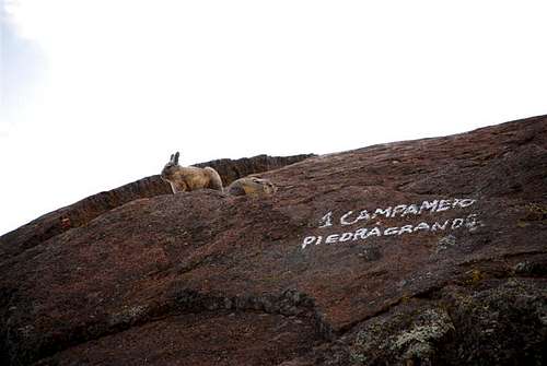 Piedragrande
The following day continue through the valley. you will enjoy the panorama and steep parts followed by flat parts of trail. As you approach to the end of the valley, keep in the middle of it and finlly, at around 5350 meters go straight to the north and climb a very steep landslide. Over there you will find a flat space and a snowfield to melt snow for cooking and drinking (there is a little river but water contains sulphur).
you are here at 5600 meters and this is a got place to set up your high camp. If you go above next to the col, you will enjoy strong winds, there you are protected.
Summit day
 Route to Cachi summit
Summit day you should start very early because the weather will probabli change around 11-12 AM so you should be on the way back and next to the high camp at that time (viento blanco storms are usefull up here, not a good idea o stay outside).
 Viento blanco storm at 6 PM
From the high camp walk North to a flat space which drives to a col. If you are fit, keep the left of this enormous space and join the col next to some rocks above the lowest point. From there follow the ridge to the Ollada (a virtual summit which is part of Cachi's South ridge.
From there you just have to follow he wide ridge to the north to reach the summit.
Consider you will take almost 5 hours if you are quick to reach the summit. If you see fog coming up quickly from the valley turn back or you will need to use your GPS to find the camp!
Gears
Complete expeditiion gear and food reserve for extra days in case of bad weather.Take purifying pills with you for the water you drink from the river. there is a rich wildlife usig the same bathroom!
Other summits from high camp
From high camp it is possible to reach the Antifeatro (6000 m ?) by following the ridge (4 hours to the summit).Climbing Cerro de lo Arcas is a good alternative to change your way back to Casa de Piedra camp (2.5 hours to summit).
 Cerro de los Arcas
Download the interactive Google Earth map
Useful Maps
Google Earth interactive mapProvince of Salta