
-
 5784 Hits
-
 80.49% Score
-
 12 Votes
|
|
Mountain/Rock |
|---|---|
|
|
48.57570°N / 120.84034°W |
|
|
Skagit |
|
|
Mountaineering, Scrambling |
|
|
7230 ft / 2204 m |
|
|
Overview

New Morning Peak at sunset from Easy Pass

New Morning Peak above Easy Pass
Getting There

At the top of the ridge heading to New Morning Peak

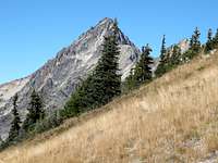
Climbing the grassy slopes near Easy Pass

Summit Block of New Morning Peak

Cross Granite Creek on a very well-built log bridge, and then start climbing. The trail to Easy Pass is 3.5 miles long and gains 2,700 feet, but it is well-graded and a good trail. Approximate hiking time to Easy Pass(6500 feet) is about 2 hours. Easy Pass is a beautiful parkland with lovely larch trees and grassy meadows.
From Easy Pass, climb grassy slopes to the northwest, gaining 700 feet to about 7200 feet. From here, traverse on top of the ridge towards the summit block. In the Cascade Alpine Guide, Volume II, Fred Beckey makes the climb sound as easy a just a bump along the ridge. It is not nearly so trivial. The ridge starts out broad and easy, but narrows signficantly in to a knife ridge with exposure. The climbing is not especially difficult, but it is loose and dangerous. It is easiest to drop below the ridge on climber's right to avoid cliffs. This will take you to a reddish gully. The rock is most solid on the margins of the gully rather than the middle. The summit is only about 50 vertical feet above once you reach this point. Climb the gully on the margins, taking care with the loose rock.
Red Tape and Camping
A Northwest Trailhead Parking Pass ($5/daily, $30/year) is required to park at the Easy Pass trailhead. You can also purchase an Interagency Pass ($80/year) which is good at any Forest Service trailhead, or for entry into any US National Park.
There is no camping allowed at the Easy Pass trailhead or at Easy Pass itself. Easy Pass is the boundary for North Cascades National Park. The only permissible camping in the area is in Fisher Creek Basin, about 1300 feet below and 2 miles from Easy Pass. The Park Service keeps a very tight rein on those wishing to camp in this area. Don't be surprised to find rangers lurking about who will give you a citation if you don't camp at the Fisher Creek camp and camp elsewhere in the area. You have been warned!
External Links


TOPO! Software Image
Also, webcams are available from the Washington State Department of Transportation at:
WSDOT Webcams
For camping or other information from the National Park, you can access the Park Service website:
North Cascades National Park
To contact the Ranger Station directly, write or call:
North Cascades National Park
7280 Ranger Station Road
Marblemount, WA 98267-9755
(360) 873-4590
Fred Spicker - Sep 28, 2009 3:55 pm - Voted 10/10
First Ascent infoApparent first ascent was 12 August 1973 Check here: John Roper's site
Snidely Whiplash - Sep 28, 2009 5:57 pm - Hasn't voted
Re: First Ascent infoPretty remarkable that it wasn't done until 1973, 5 years after the road opened. It's pretty close to a very popular destination. Hats off to you for a solo ascent. It's hairy enough with someone else. Beckey's description makes it sound like a walk-up along the ridge, which it most certainly is not.