
|
|
Mountain/Rock |
|---|---|
|
|
37.26200°N / 110.5705°W |
|
|
San Juan |
|
|
Hiking |
|
|
Spring, Summer, Fall, Winter |
|
|
6101 ft / 1860 m |
|
|
 Navajo Mtn & the side of Nokai Dome
 Route map
Overview
Want to test your vehicle and drive down a road that was part of history? Want to see an area very few others will ever see (or want to see)? Then perhaps a visit to a peak known as Nokai Dome is for you. Actually, only a jaded prominence peakbagger would even consider doing this one so the best thing you can do is move on to another SP page. Trust me, you'll be glad you did.If you are still reading this, then here is some more information about this one. The word Nokai has nothing to do with phones (Nokia) but in this case it is a Navajo word that means "Mexican Waters" (from Utah place names p. 276). When I was looking at the prominence peaks in San Juan county, this name jumped out at me. When my son in law also listed it as a place he'd like to visit, I got busy in making maps and waypoints for it. That turned out to be a key thing because this place is really out in the middle of nowhere, way out. My map did not indicate the changes wrought by the re-routing of the Hole In the Rock Trail road (HITR) It has a prominence of 1201' which also was of interest as I am interested in any peak/mountain that has a prominence of over 1000 feet (there are 360 of them in Utah).
The road to Nokai Dome is now part of the HITR road (the eastern side) and when the HITR had to be re-routed due to an impassable washout in March 2009, they ended up using about 2/3rds of the Nokai Dome road to re-route to. I've indicated on a map I've made where that leaves the Nokai Dome road. Prior to the joining of the HITR that was re-routed, the access was via a primitive 4WD road most likely put in by the uranium miners of the 50's. I can believe that by re-routing the HITR trail road, it made our drive somewhat easier. There are still sections that will make you glad you have a high clearance 4WD (do not attempt this in anything else and make sure you have plenty of water and supplies if the event of a breakdown).
There are two Hole in the Rock roads and this one, HITR is often confused with the Hole in the Rock Road, the 56 mile maintained dirt road from Highway 12 near Escalante, which follows the first portion of this same trail blazed by the Mormons of the San Juan Mission in 1879 to the now impassable Hole in the Rock road cut. Almost anything with tires can make the drive from Escalante to the Hole in the Rock. I could recommend reading the book "The Undaunted" (about the pioneers who blazed the HITR but this page is really dedicated to helping you find the way to Nokai Dome and not to bore you with a history lesson. (see note at the bottom section)
Getting There
 |  |  |
From highway 276, watch for the Hole in Rock road sign. That is what you turn off on. I'll add GPS coordinates for it so you can zero in on the turn (I almost drove past it). Fortunately I had it waypointed and that saved the day since the sign was easy to miss. The Benchmark Map does show the Nokai Dome road. I trusted my GPS waypoints and they paid off. The topo maps didn't show the changes of course but the maps that I used worked anyway and I hope they will aid you as well. After driving through a sand dune at the very beginning, the road was pretty good and a sign for Hole in the Rock a couple miles in at a junction was a big help. Turn on the Hole in the Rock road and stay on it as the road roughens in places. When you see a windmill to your right, watch for a fork where you go left up a rocky section. Stay on that and the next landmark of sorts will be an abandoned half track truck on the left side of the road. Here also is another sign for the Hole in the Rock road and the first sign I saw indicating that I was on road 261. It was also the last 261 sign I remember seeing. Stay on the road and when you see another road that drops down and goes off to the left, you also will see another Hole in the Rock sign that points you in the right direction. From this point you start gaining elevation as you work your way up to another fork at the top of the rough road that takes you up through a canyon. At this fork is another sign for the Hole in the Rock road. This time you go straight and you will also have put close to ten miles on your odometer. You are now have less than 5 road miles from Nokai Dome and you might be able to drive at least 3 1/2 to 4 of those miles. After you pass an old abandoned shack (miners?) on your right, the road gets steadily worse and you can park and walk any time you feel that it would be best to do so. When you get to the point where you could walk faster than you can drive, you'll have reached the time to park it.
From the pavement to the top of Nokai Dome, roughly, it was about 15 miles. I didn't keep exact measurements of the distances other than note the mileage when I turned off the pavement and the mileage at the point where I parked. Why? I really didn't think I would get close enough to Nokai Dome to be able to do it. I had felt that we might get stopped by either sand, bad road or a washout since my map showed that most of the mileage would be on a rough 4WD jeep track.
Update: Last year, Greg Jagielski and Kadee made the trip and Greg reported that the roads seem to have been graded and he felt the roads may have been improved over what I have reported. For more information, contact Greg at gjagiels here at SP.
 |  |  |
Red Tape
It is BLM land and as far as I know there is no red tape. | 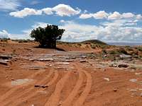 |  |
Camping
There were several possibilities for a bush camp but there are no established campgrounds in the area. The closest facilities would be found at Halls Crossing on Lake Powell. |  |  |
Weather for Lake Powell area


Historical tid bits and links
 |  | [img:645545:alignright:small:] |
One of the reasons that the road to Nokai Dome was created and is fairly wide near the Dome is the fact that the Skelly Oil company tried to find oil in the area. Perhaps that was one of the main reasons why an airfield was built up on there, to service the oil company needs. Skelly struck out as their efforts to find oil there resulted in a dry hole.
Evidently, where the old half track is found on the way in is where the original (before March 2009) HITR road and the road to Nokai Dome split.
I found this statement on a web page:
" The trail is easy until you reach the fork in the road at the old truck about four miles in. If you head to the left you will begin a steep ascent towards Nokai Dome. That trail dies after 6 or 7 miles atop the summit, but affords some awesome views and an exhilarating ride."
So from the above statement, the Nokai Dome road was before March 2009, only for the access of Nokai Dome. After the washout on the original road, they shifted to use some of the Nokai Dome road. That cleared up
a bit of a mystery for me.
Hall's Crossing was originally established as a ferry crossing by Charles Hall in 1880 at the original Hole in the Rock crossing used by the mormon pioneers. The approach were so bad that he had few customers and so moved the ferry up the river 35 miles hoping for better business. It didn't improve things much and he gave up the ferry business in 1884. However, the name Hall's Crossing, is still used today and is the site of a very successful ferry operation that goes between Hall's Crossing and Bullfrog.
Click here for Internet resource on the Trail by a 4 wheeler
Click here for yet another resource
Another link worth looking at.
"The hundred miles of road built after descending the Hole-in-the-Rock crossed some of the most rugged terrain in North America. Deep ravines and washes were crossed, trails down thousand-foot drop-offs blasted, deserts traversed, paths through thick cedar forests cut, and steep cliffs ascended. Many grades required seven spans of horses to pull the heavily laden wagons, and the worst stretches could be identified by the blood and matted hair from the forelegs of the struggling teams.
In all, the trek took six months. Food supplies were depleted, and teams had been worn to the point of exhaustion. Two babies were born en route and, miraculously, no one had died. The pioneers had toiled under the most trying of circumstances in a harsh land. Most significantly, their ordeal forged them into a self-reliant colony ready for the formidable tasks of nurturing peace with the Indians, controlling the lawless who sought refuge in the area, irrigating with the unruly San Juan River, and eking out a living from the sun-baked land."
From History to Go/utah
A good book to buy if you want to know more about the Hole in the Rock trail is one called "A guide to Southern Utah's Hole in the Rock Trail" by Stewart Aitchison.
Warning
I was able to negotiate the road to the turn off with the HITR (first 10 miles) fine as my vehicle is high clearance and has 4WD capability (which I used in several places). The HITR separates off and the Nokai Dome road continues straight ahead. I drove 4 or so miles on this road and was amazed at the quality of this section of road, it was certainly better than I expected it would be. That all changed about a mile from Nokai Dome, as the road became very rough and while I drove some of the rough section, I decided to park and walk the rest of the way. Easy to do. There is an old miners shack that you will pass and I'd recommend parking not too long after you pass this shack. The walk will do you good after all the jarring that you will have endured to get to this point. Once again, do not attempt this peak with out having a high clearance vehicle with 4WD and enough water and supplies to sustain you in the event of a breakdown. Let others know where you have gone and the best way to do this one would be to have two vehicles.We did have cell service from the top of Nokai Dome (rather fitting, don't you think?) We used both AT&T and Verizon services to make our contacts. If you decide to do this one, you do so at your own risk. After you do this one you might think that I have been overly cautious but you are a long way from help and a breakdown is a very real threat. Do not drive these roads in wet weather, they may become impassable until they dry out. OK, enough of that.
If you were to continue on to the Hole in the Rock, the authors of The Undaunted have made the following observation:
"The trail is ranked by ATV experts as a 6, which is ―difficult.‖ It is grueling, demanding, and can even be dangerous if one is not
properly prepared. You will be out of cell phone range for virtually the entire time. It is not unusual to spend two or three days out there and not see anyone else, so you should never do it with only one vehicle. If you have a breakdown, get lost, or experience a medical emergency, getting help is a challenge. Even those who know the trail best occasionally miss
a turn and have to backtrack because so much of the trail is over hard rock surface and is not easily discernible.
Due to the risks involved for the less experienced traveler, we strongly recommend that you explore this part of the trail only with someone who is an experienced guide. If you need a commercial guide service, the only one we know of that offers such services over the trail is Black Hawk Transportation in Blanding (follow the ―Tourism‖ link on www.blandingutah.org). They provide escorted tours, including overnight experiences with meals, as well as ATV rentals. You may wish to check Moab rental and guide sites as well, but Moab is over 100 miles away, and we could not find any that advertised escorted trips to the Hole in the Rock."