
|
|
Mountain/Rock |
|---|---|
|
|
37.75640°N / 119.5589°W |
|
|
7542 ft / 2299 m |
|
|
Overview
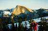
North Dome, located on the north side of Yosemite Valley above Royal Arches and Washington Column, offers some of the very best views of Half Dome's awesome North Face and Clouds Rest. Routes range in difficulty from a family-outing YDS Class 1 to technical 5.11c A0 adventures. And while there are some technical classics such as Crest Jewel, the views from this dome are so stunning that it should be near the top of every Yosemite visitor's list. Morgan writes, "It's often been said that a climb of Half Dome is disappointing for a simple reason: from the summit you cannot see Half Dome! In my mind, North Dome has one of the very best views of Half Dome's awesome north face, not to mention of Yosemite's southern hinterlands."Do not miss this gem on your travels to Yosemite :-)
|
 |  |  |  |  |
Routes Overview
Here is a list of routes for North Dome arranged in alphabetical order. The most popular route is the non-technical 0.5 mile class 1 North Dome Trail that is accessed by several other trails listed in the approach section below.
| ||||||||||||||||||||||||||||||||||||||||||||||||||||||||||||||||||||||||||||||||||||||||||||||||||||||||||||||||||||||||||||||
Getting There
TIOGA ROAD APPROACH (Porcupine Creek TH): The trailhead is on the south side of CA SR-120 (aka Tioga Road) between the turnoffs for White Wolf and May Lake (for Mount Hoffman). It is ~12 miles west of Tuolumne Meadows. YOSEMITE VALLEY APPROACH (Yosemite Falls & Snow Creek THs): For general transportation information, refer to the Yosemite Valley page. Make your way to Yosemite Village on Highway 140. Refer to trailhead summary in Routes Overview section above to reach this trailhead.
Camping/Lodging Information
General Yosemite camping information. You must obtain a free wilderness permit for overnight trips into the backcountry. Depending on your desired trailhead, you can use the Tuolumne Meadows permit office, or the permit office in Yosemite Village, near the post office.My friends and I actually camped on the small dome west of North Dome on Thanksgiving, after climbing the Yosemite Falls Trail.
The best trail for Yosemite Falls trail is the Sunnyside walk-in campground in Yosemite Valley. It is inexpensive, for tents only, and first-come-first-served. Upper and Lower Pines campground in Yosemite Valley are the logical choices for the Snow Creek trail. The Porcupine Flat campground is only one mile from the Porcupine Creek trail, and thus the best choice.
Yosemite Valley non-camping lodging options Note: I had my wedding reception at the Ahwahnee Hotel. If you are willing to spend some serious money ($300+/night), a stay at the Ahwahnee is an unforgettable experience.
Hiking Loop Options
Snow Creek + Yosemite Falls: This demanding loop is about 20-22 miles long, depending on whether you walk all the way back to your car. Snow Creek or Yosemite Falls + Porcupine Creek: If you hate climbing hills but don't mind long descents, try starting at the Porcupine Creek trailhead, visit North Dome, then descend either the Snow Creek or Yosemite Falls trail. Conversely, if you perversely enjoy lots of climbing, reverse your path. Either way, you can utilize Yosemite's shuttle bus (YARTS) to drive you back to your car. Information on YARTS can be found here. Note that this option is only possible when Tioga Road is open (June-November).
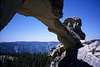
Interesting side trip: Indian Rock
If you approach North Dome from either the Porcupine Flat or Snow Creek Trailheads, you may notice on the 1:24000 USGS topographical map an interesting feature: Indian Rock (Natural Arch). Referring to this map, note that Indian Rock is the 8500-foot summit at the north end of Indian Ridge. Getting there from the North Dome trail is easy. Rather than crossing Indian Ridge at 8100' as you head north, away from North Dome, follow Indian Ridge to the northeast until you come to Indian Rock. From Indian Rock, you can quickly and easily descend to the east and rejoin the main trail out.
 |  |  |  |  |
Backcountry Skiing
I haven't skiied this area before, but I can tell it has great potential, at least for backcountry touring, if not for 2000-foot descent. The most logical approach is via the Snow Creek Trail, with a great descent option being a direct drop from the ridge connecting Indian Rock and North Dome down to the Snow Creek Trail. In addition to cutting three miles distance from your return trip, this would likely be an exhiliarating run of 30-degree tree skiing.My wife skied Mount Watkins (8500 feet high, east of North Dome) in May (of an El Nino year) with her brother, climbing up Snow Creek trail. A Tuolumne Meadows/Tioga Road ski tour could be great fun, if a bit long and flat. Certainly one could exit Yosemite Valley via either Snow Creek or Yosemite Falls trail.
If you have skied this area, please add information! I will update and credit you here.
External Links
- Morgan's North Dome image gallery
8 images
- Morgan's "North Dome Loop" Backpacking trip
What a great way to spend Yosemite. My "big screen" was Half Dome, not a college football bowl game.
- South Face of North Dome Climbing Beta
Beta and photos of the South Face of North Dome
- A climb of North Dome Gully - Nov 2, 2002