
|
|
Mountain/Rock |
|---|---|
|
|
31.88580°N / 130.91400°E |
|
|
Kagoshima/Miyazaki |
|
|
Hiking |
|
|
4659 ft / 1420 m |
|
|
Overview

Ohachi (御鉢) is the smaller western companion of Takachiho-mine (高千穂峰). Both stratovolcanos form an unequal pair, while Takachiho-mine is a high perfect cone with a summit tip, Ohachi's conical shape ends in a large crater giving it the name - the bowl. As a pre-summit all climbers of Takachiho-mine using the route on the west side from Takachiho-gawara (高千穂河原) are climbing the summit of Ohachi as well.
Ohachi is one of two volcanic craters in the Kirishima area that showed volcanic activity in recent times. The last active period of Ohachi ended with fierce volcanic eruptions in July 1923 causing fatalities. Since then Ohachi remained rather quite until some new fumarolic vents were formed in December 2003. So far (May 2009) this activity remains on a rather low level and has no interference on climbers of Ohachi and Takachiho-mine. The only sign for the most people is the smell of hydrogen sulfide -the perfume for volcano enthusiasts- that is so characteristic for this kind of mountains.
There exists a trail that circumvents the whole crater, but it is currently blocked on the southern side.


The Kirishima mountain range as a part of the Kirishima-Yaku National Park is located in the southern part of Kyushu 200 km south of Fukuoka and 50 km northeast of Kagoshima. Many volcano enthusiasts refer to Kirishima as the finest volcano range in Japan. More than twenty volcanic cones and and a dozen crater lakes form an exceptional area worth a multi day visit. In the lower regions dense forest cover the area like a green carpet. The main reason is the high precipitation since the Kirishima range seems to catch any passing rain front. The annual rain amount is twice as high as that of Kagoshima just a few kilometers apart.
Due to the weather conditions some rain protection should always be a part of the gear. Kirishima can be visited the whole year around but the rain season from around mid of June to July is better avoided. Trails might become muddy and some slopes and descends can even turn dangerously slippery.
The Kirishima area is also well know for its onsens (hot springs). A visit of one of the numerous onsens within the area will be the best end of a hiking day.


Getting There
 Looking into the crater
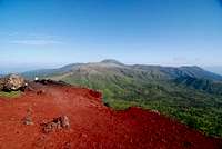 View from Ohachi to Karakuni-dake
The closest trailhead for a climb is Takachiho-gawara (高千穂河原), which is best accessible from the South. There are several bus connections with the city of Kagoshima via Kirishima town. The closest train station is Kirishima-jingu with train connections to Kagoshima.
Many hikers come to Takachiho-gawara while doing a Kirishima traverse starting in Ebino Kogen, which has connections to North and South and is faster achievable from Fukuoka via highway bus. Here is a description of this route: take one of the buses to Miyazaki (宮崎) until Kobayashi (小林) IC. Close to the highway bus stop one can change to a local bus to Ebino Kogen. Unfortunately, this bus coming from Kobayashi goes very infrequently. Therefore, one can also start hiking from here towards the Ebino plateau or hitchhike. Since the most people going to Ebino are also hikers, it is not a big problem to catch a ride.
One can also try to hitchhike from Ebino Kogen to Takachiho-gawara. Shouldn't be a big problem to find a ride there as well.
There seems to be a bus connection from Kagoshima to Ebino Kogen. Any comment about this is highly appreciated.
Timetables for the highway buses either via Nishitetsu or the Raku bus and for trains on hypedia or the JR Kyushu website
Red Tape
 Crater view
Currently (May 2009) there are no restrictions. Keep an eye on the volcanic activity for example at the USGS website.
Route
 Climbing the angry snake in the morning
 On the crater
 Busy tour
The climb starts at the tourist information in Takachiho-gawara (高千穂河原). At the beginning there are two possibilities. Either one walks to a shrine and climbs afterwards the trail in the forest or directly enters the forest behind the parking lots. The later option offers some rest/picnic areas just a few minutes after the start with excellent views to the South over the lower dense green forests towards the bay of Kagoshima and the active Sakurajima volcano with its constant steam or ash plume.
After about 15 minutes both trails join and the climb on an old lava flow starts. This section -called the "angry snake"- is very unique mainly due to the red color of the ash. It is assumed that this is the remnant of pyroclastic flows from the eruptions of the years 945 or 1235. Here everyone chooses his own trail and competes with the loose and step scree slope. Viewing up, most people go on the left side at the beginning and change in the last third to the right side with some more solid rock. There are yellow marks on the rocks showing the route.
Just about 45 min after the start in Takachiho-gawara the crater rim is achieved and the further trail to Takachiho-mine is visible. To climb the highest point of Ohachi one has to pass the crater on its northern edge. On several locations on the north side of Ohachi one can see the layer structure of the volcanic ash since some smaller land slides removed the cover layers. After not more than one hour in total Ohachi is climbed and the trail continues towards Takachiho-mine.
Camping
There is a good campground at Takachiho-gawara west of the tourist information and parking lots. A site for a tent costs about 1100 Yen per night plus a small charge per person. You can also rent a big tent for 10 person there for about 2800 Yen. The camp site offers hot showers and barbeque facilities. The Kirishima town website says the site is only open from July to August. We have been there during Golden Week in May and the camp ground was open and used.The Lonely Planet guide book describes some camping possibilities beside the tourist information. I haven't seen anyone camping there, but probably it is worth to ask. No hot showers there.
There are some noodle shops in Takachiho-gawara but no stores for food and other supplies.
External Links
Excellent topographic online maps covering whole Japan and the corresponding map of OhachiJapanese mountain database
The websites of Ebino city and Kirishima town
Weather forecast of Japan Meteorological Agency
Literature
Lonely Planet "Hiking in Japan"ISBN 1-86450-039-5