, the pyramid above us and in winter there "steals" the sun. But because we were gone? It's not you, that until that day you have in mind only the Football, you get up one morning and decide to climb the "Becca". I had dropped out of school with my diatribes Woman Professor of Italian (very good and unfortunately, even more demanding, especially in Latin but also in History and Geography. Throughout, unfortunately. A hammer that never gave up. Or resist or outbursts. I burst out.) and my father, when I announced the idea to my mother, desperate to want to abandon his studies after getting out of bed the night shift at the factory and having heard it all, calmly invited me for the next day to take the bicycle at dawn that would take me to find a job. He took me by a friend with whom he had made the Partisan and I settled down, "attendant", that is in the distributor and seller of gasoline when there were no cars on the forecourt (almost never) in washing machines. Working hours: 6.00 am to 23.00 pm with a half hour for lunch sandwich. Including Sunday, including public holidays from April until September. Pay 30.000 £ ( approximately $ 16) per month all inclusive, plus tips. I learned to count in English, German, Dutch, Swedish and also in Turkish. And to defend myself, because the older they wanted to screw me the extras. But one day the square came two "Tartarini" (just like that of Tarasconne) and began to recount their stunning exploits on the Becca of Nona, as well as the gigantic events that occurred with large boulders that rolled down from the wall of Emilius. I listened open-mouthed this breathtaking story. I had already heard Peter and Horst , two Germans of Munchen (Muncccchhheeenn Horst trying to get me to learn the right words that sound nasal half and half guttural, which, when you tried to imitate him looking in the mirror, you seemed to have become a baboon), who came linguistic support to the distributor, had gone to make the Gran Paradiso. But we know the Germans were not so passionate and their story had been cold and stiff. But came up with the sneakers and without crampons and this gave me to reflect. But these "Tartarini" no. These were full of passion in their story and you dragged enthusiasm. All other Trip Report: glacial the first, the second burning. They had me convinced. In a week I would have ended the period of employment and also I would go to do the "Becca". Arrived in the evening at home I immediately spoke with my brother Dario and Hilary. It was done, we went to the "Becca" . I also took the Arthur, one of us younger, and went.
We took the idea a year later, to do some hiking on the surrounding area. After a trip to Mount Fallère
(3061m), one at Black Head and the return to "Becca" with a dozen companions, half the country, we were ready for the Emilius. Beautiful pyramid! But who knows where it goes? Here in front of Becca certainly not. It has a very high wall and dangerous. We sought to examine a passage in the same, but without specifying anyone. Then you have to go from behind, as we tried to figure out from the Black Head. But around that long ... Here it takes two days, starting from our house
(559 metres) and then we have to organize an expedition. By now there was no talk in the country over another. The Football season had ended and Walter Bonatti had shocked everyone with "Direttissima" Lonely Winter and the North Face of the Matterhorn. They had also said on Television. Everyone felt and wanted to become Bonatti. So are we. And then it was also the Centenary of the first ascent by Edward Whymper. By now we knew everything, because the guys are like that. When you 're mad at something does not stop them anymore.
Emilius tremble, because we come ...There was an incredible turmoil, agitation, ferment and movement: who tried blankets, who was planning the clothing, who was interested in the dietary part of the course and who to follow. An incredible stroke of luck allowed us to discover a 1:100,000 Map of the Aosta Valley It was made! The journey could begin. Our journey, without Sherpa or Porters , without Mountain Guides or Carriers and, if anything, asking for information and instructions for the Street pastors. More genuine than that! ...
Saturday, July 17, 1965 we go. To top all through the forest that we know well, because that's where our explorations take place every day. Then bend a little to the right and reach the Hermitage of Saint Grat
(1787m), the hard and very steep muletrack leads to Lake Chamolé and to the above hill
(2641m). We are a good group and we are tired, and to download weight, begin to affect food supplies: more above four or five biting into a nice brown bread stuffed with cheese; under other devour a round bread
"bad and good" filling salad. It looks like the meal of lions. Bypassed the hill, we go down in the Walloon of th'Arbolle
(2500m). There is no one and the miserable shelter, without even the door, with the roof in a mess and a little straw on the floor makes us understand what kind of night awaits us. We play on the shores of the lake and we also find, under the straw, a true
" musket" (Gun Smuggler). Then, arriving in the evening, we become more reflective and decide to go exploring the path for the next day. Wrong and all plodding along endless stony, too West of where the trail passes, we arrive at the base of the pyramid. There, a stone's throw from Emilius, but the darkness that falls perplexes us and we go back .
Tomorrow we'll see.
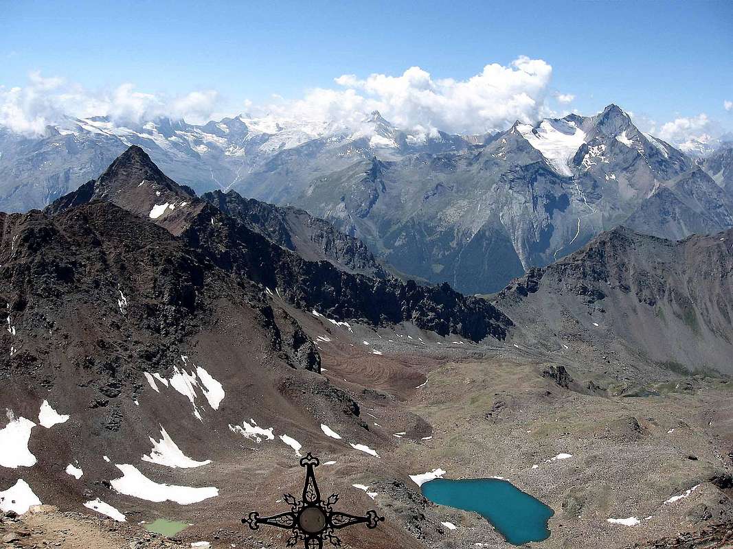
Sunday 18th, 1965. At 3 o'clock in the night, the door, which we had momentarily put up against the entrance, it collapses on him. A shouting excitedly in patois dialect wakes us up, and some dark figures come in, without saying anything and tables spill pallet, take the rifle and disappear into the darkness. Luckily we had placed him. Poachers are, and as they came, so they leave. As the mournful Ghosts. Later in time I'll know who they were. One, A. C., was a famous boxer who had fought for the Italian title. Disturbed by these intruders and raised by their presence, we prepare and soon, as soon as the first light appear out over the gloomy pyramid Garin still in shadow, we're off. We devour the way, now exploring the night before we opened our eyes. Upward to Lake Frozen, Ancient Glacier of Emilius, who was then still existed, Three Capuchins Pass and then a mad rush, as if playing a first come, almost flying on the ridge above the large blocks stacked. So tired that we run with your eyes closed. And when I open them suddenly takes me a shot to the heart: one more step, just one, and I would have jumped into the abyss of the East Wall With a vertical drop of
500 meters. At the top at 9.00 am we are four: Hilary, Walter , Louis and me. A clear sky and bright it opens before your eyes an infinite horizon, with the Matterhorn, over there , which seems to congratulate us. Th'Emilius is done, the spell is broken and even the tumble that Walter gets down to 30 metres in a gully by breaking the clothes but no major damage we can worry . Laughing happy, let's go down by the younger ...
"Turn back, Guys, you find the Way / Girate dietro, Ragazzi, per poter continuare il vostro Viaggio"
Come abbiam iniziato?
Nell'anno precedente eravam stati alla Becca di Nona (3142 m), la piramide che ci sovrasta e che in inverno ci "ruba" il sole. Ma perché c'eravam andati? Non é che tu, che fino a quel giorno hai in mente solo il Calcio, t'alzi 'na mattina e decidi di salir alla "Becca". Avevo mollato la Scuola per diatribe con la mia Professoressa di Italiano (molto brava e, purtroppo ancor più esigente, soprattutto in Latino ma anche in Istoria e Geografia. In tutto, purtroppo. Un martello che non mollava mai. O reggevi o scoppiavi. Scoppiai.) e mio padre, quando annunciai l'idea a mia madre, disperata, di voler abbandonare gli studi alzandosi dal letto dopo il turno notturno in fabbrica ed avendo ascoltato il tutto, senza scomporsi, m'invitò per il giorno dopo prender bicicletta all'alba che m'avrebbe portato a trovar lavoro. Mi condusse da un suo amico con il quale aveva fatto il Partigiano e mi sistemò: "benzinaro", cioé venditore di benzina nel distributore e quando sul piazzale non v'eran auto (quasi mai) dentro a lavar macchine. Orario di lavoro: ore 6,00 ore 23,00 con mezz'ora a pranzo pel panino. Domenica compreso, festività comprese da Aprile fino a Settembre, compreso. Paga 30.000 £ (16 dollari circa) al mese tutto compreso, più le mance. Imparai a contar d'inglese, tedesco, olandese, svedese ed anche in turco. Ed a difendermi, perché i più vecchi volevan fregarmi gli extra. Ma un giorno sul piazzale arrivarono due "Tartarini" (proprio come quello di Tarasconne) e si miser contar lor strabiliant'imprese sulla Becca di Nona, nonché degli eventi ciclopici che s'eran verificati con grandi macigni rotolanti giù dalla parete dell'Emilius. Udivo a bocca aperta questo racconto mozzafiato. Già avevo ascoltato Peter ed Horst, due tedeschi di Monaco (Muncccchhheeenn per Horst che disperatamente cercava di farmi apprendere la giusta dicitura di quel suono mezzo nasale e per metà gutturale, che, quando cercavi di imitarlo guardandoti allo specchio, ti sembrava d'esser diventato un babbuino), che, venuti di supporto linguistico al distributore, eran andati fare il Gran Paradiso. Ma si sà i tedeschi non eran così passionali ed il loro racconto era stato freddo e compassato. Però eran saliti con le scarpe da ginnastica e senza ramponi e ciò mi dava un pò da riflettere. Ma questi "Tartarini" no. Questi eran pien di passione nel loro racconto e ti trascinavan all'entusiasmo. Tutt'un'altro Rapporto di Viaggio: glaciale il primo, infuocato il secondo. M'avean convinto. Tra una settimana avrei finito il periodo lavorativo e sarei andato anch'io a far la "Becca". Arrivato la sera a casa parlai subito con mio fratello Dario ed Ilario. Era fatta, s'andava in "Becca". Prendemmo anche l'Arturo, un di noi più giovane, ed andammo. Era il 3 di Settembre 1964
La Prima Spedizione
Avevam preso l'idea, l'anno dopo, di far qualche escursione sul territorio circostante. Dopo una gita al Mont Fallère
(3061 m), una alla Testa Nera ed il ritorno in "Becca" con una decina di compagni, mezzo paese, eravamo pronti per l'Emilius. Bella piramide! Ma chissà dove cavolo si passa? Qua davanti alla Becca di sicuro no. Ha una parete molto alta e pericolosa. Avevam cercato di scrutare un passaggio dentro la medesima, ma senza individuarne nessuno. Allora si deve passar da dietro, come avevam cercato di capir dalla Testa Nera. Ma che giro lungo ... Qui ci voglion due giorni partendo da casa nostra
(559 metri) ed allora dobbiam organizzar 'na Spedizione. Ormai nel paese non si parlava d'altro. La stagione del Football s'era conclusa e Walter Bonatti aveva choccato tutti con la "Direttissima" Invernale e Solitaria alla Parete Nord del Cervino. L'avevan detto anche in Televisione. Tutti si sentivan, volevan diventar Bonatti. Anche noi. E poi era anch'il Centenario della prima ascensione di Edward Whymper. Ormai sapevam tutto, perché i ragazzi son così. Quando si appassionano ad un qualcosa non li fermi più.
Emilius trema, perché arriviamo ...C'era n'agitazione, un fermento e movimento incredibil: chi cercava coperte, chi programmava il vestiario, chi s'interessava della parte alimentare e chi del percorso da seguire. Un colpo di culo incredibile ci fece scoprire 'na Carta della Valle di Aosta 1:100.000. Era fatta! Il viaggio poteva iniziare. Il nostro viaggio, senza Sherpa o Portatori, senza Guide e, semmai, chiedendo informazioni ed istruzioni per istrada ai Pastori. Più genuin di così! ...
Sabato 17 Luglio 1965 si parte. Tutti sù traverso la foresta che conosciam bene, perché lì avvengono le nostre esplorazioni giornaliere. Poi pieghiamo un poco a destra e raggiungiamo l'Eremo di San Grato
(1787 m); la dura e ripidissima mulattiera ci porta al Lago di Chamolé ed al soprastante Colle
(2641 m). Siamo bel gruppo e siam stanchi e, per scaricar peso, cominciamo ad intaccar le provviste alimentari: più sopra quattro o cinque addentano un bel pane nero imbottito di fontina; sotto altri divoran un rotondo
"brutto e buono" ripieno d'insalata. Sembra un pasto di leoni. Scavalcato il colle, caliam nel Vallone dell'Arbolle
(2500 m). Non c'é nessuno e la miserevole baita, senza neppur la porta, col tetto in disordine ed un pò di paglia sul pavimento ci fa comprender che tipo di notte ci'aspetta. Giochiamo sulle sponde del lago e troviamo anche, sotto la paglia, un vero "moschetto" (Fucile dei Bracconieri). Poi, arrivando la sera, diventiamo più riflessivi e decidiam d'andar esplorare il percorso per il giorno appresso. Sbagliamo tutto ed arrancando lungo sterminate pietraie, troppo ad Ovest di dove passa il sentiero, arriviamo alla base della piramide. Lì ad un tiro di schioppo dallo Emilius, ma il buio che cala ci lascia perplessi e ritorniamo dietro.
Domani vedremo.
Domenica 18, 1965 Alle ore 3, in piena notte, il portone, che momentaneamente avevam risistemato in piedi contro l'ingresso, ci crolla addosso. Un vociare concitato in dialetto patois ci sveglia, mentre alcune figure scure entrano, senza nul dire rovesciano tavole e pagliericcio, prendono il fucile e spariscono nell'oscurità. Per fortuna lo avevamo riposto. Sono i Bracconieri e, come son venuti, così se ne vanno. Come dei lugubri Fantasmi. Più in là nel tempo saprò chi erano. Uno, A. C., era un famoso pugile che aveva combattuto anche per il titolo italiano. Disturbati da questi intrusi e sollevati dalla loro presenza, ci prepariamo e presto, appena le prime luci appaiono uscendo sopra la tetra piramide della Garin ancor in piena ombra, partiamo. Divoriamo il percorso, ormai l'esplorazione della sera antecedente ci ha aperto gli occhi. Sù al Lago Gelato, Antico Ghiacciaio dello Emilius, che allora esisteva ancora, Passo dei Tre Cappuccini e poi una corsa forsennata, quasi giocando a chi primo arriva, su per la cresta quasi volando al di sopra dei grandi blocchi accatastati. Talmente affaticati che corriamo ad occhi chiusi. E quando improvvisamente li riapro un tuffo al cuore mi prende: ancor un passo, un solo, e sarei saltato giù nell'abisso della Parete Est. Con un salto verticale di 500 metri. In cima alle 9,00 del mattino siamo in quattro: Ilario, Walter, Luigi ed io. Un cielo terso e limpido ci spalanca davanti agli occhi un'orizzonte infinito, con il Cervino, laggiù, che sembra complimentarsi con noi. L'Emilius é fatto, l'incantesimo spezzato e neppure il ruzzolone che Walter fà giù per 30 metri in un canalino rompendo i vestiti ma senza grandi danni ci può preoccupare. Ridendo felici, torniamo in basso dai "bocia" ...
Unknowingly twice on the trail & A third time almost by accident
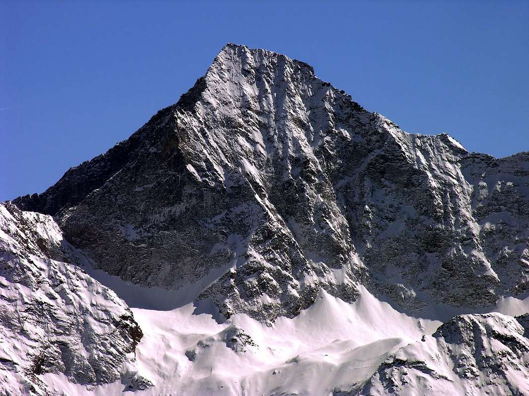
Other pyramids appear in front of us
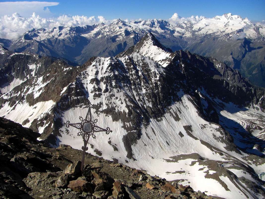
Northern Faces of three Punta Rossa & Peak Garin (outline right Southwest Ridge) from Emilius Summit, by Corvus
Two times
Friday, August 20th, 1965: to Pic Garin Southwest Ridge with variant. So our trip was over? No, because it started just now. A series of pyramids unfolded before our eyes, one after the other like those of Egypt appear in a day in which the blinding sun mixes with the sand raised by Ghibli in a suggestion of images that blur more and more as they move away. Then they disappear in a horizon pale and fleeting.
But here in front of these no: the unknown Punta Rossa and Garin Peak solitaire provoke us by throwing down the gauntlet to us. And the challenge is ...
A big problem, because here the walloons to be overcome are four: Dard, Comboé, Arbolle and Arpisson and if the Emilius knew little of Punta Garin do not know anything. Let's leave aside for a moment the Punta Rossa, located between this and the Emilius, and we aim to Garin Peak, nicer and less depressed. Indeed , we aim to both, first one, then the other. To do this we need to
"set" a base camp. The night has been sufficient to Arbolle: best stretch of the path a little but sleeping in a place more and more
"Christian". So we organize going to take place in a house of Walter Bianquin the Great Cerise
(1472m), a fraction below the Resort Pila, but more far Northwest. Doing so will eliminate the first two walloons and a long journey to arrive Chamolé Lake, through the hill to descend Arbolle, we will pass the Garin Hill to enter the Walloon of Arpisson above Gimillan in Cogne Valley. A nice approach, then everything will become for us, as for the Abbé Henry, a total surprise. But we have been preceded by 63 years do not know anything, nor have ever known or heard of
this Mr. Joseph-Marie Henry, Abbot of the profession. And even the Mountain Guide "with mule" Grégoire Comé Charvensod, where we live. A shame ...
Saturday August 21th, 1965: Garin Peak. When we start the day looks splendid and chatting then we know that this climb quite well and then, in the future as a punishment, we will perform hundreds of times. Just as well, otherwise it would go back. What we now do with pleasure, no one knows tomorrow. For this we proceed naively, as if driven by Fate From the lake to the hill, the hill at the Arbolle and from this to the Lower Col Garin or of Arpisson. There's only by walking. They open the doors of the unknown. A crossing halfway leads us to Garin Lake
(2957m), stuck here and square shape among ancient boulders fallen from above. Over
600 metres stands the pyramid of Garin. You should, having, place the tent here and never go away. A sensation experienced a hundred times. Out of time and space. Instead they roam and we address to the Southeast. Amazing discovery! An ancient pueblo (Indian village) stone lays at our feet, telling ancient stories. Maybe it never existed. Given a look at the above, we decided to look for something more simple, for which reason we continue in this direction and, through a small slope between shattered, we're going to dub this great rocky rib that comes from the large shoulder
3207 metres at the base of the Southwest Ridge. Beyond a small basin below the South Wall with snowfields tells us that music is not different. And then we begin to climb this big iron that juts out into the Arpisson. Easily, but with fatigue, and we reach the ridge, zigzagging between some bumps in the shape of fingers, we reach the small fork at the base of the Southwest Ridge proper. This salt with about
250 metres to the Top and bottom view, it seems not to promise anything good. Instead it is easy and bypassing briefly some stretches immediately to the West, soon we carry higher. We are free from the rope, but it is not needed, the rock is broken and offers many holds. And so we come to the
"mauvais pas", where a series of large sheets appear to preclude the passage. We go one after the other and soon a more vertical stretch prevents us from continuing. Some adventure, but there is no way to go with the vacuum it magnifies and the danger increases. Devoid of risk rope. At some point I lose the balance, but, miraculously, take it back. Underneath all seems to revolve. Let's back up for a moment, then, crossing
10 metres to the right, we get around the passage, another plaque easier to take us to the edge of the ridge. From then on, everything is easy and reach the small wooden cross on the Southwestern Summit and finger tip sharp horizontal leads us to the iron located on the Northeastern Point, the highest
(3461m), but then it was also listed on the
3448 metres Garin is uphill. Now we have the descent. What do you do? Look here: everything is frozen to the North, and we, as well as rope, ice-ax and crampons we do not even. Look right down to the West Wall: do not just talk about it. Look beyond: it seems easier to the Tersiva, but then we end up in Cogne Valley and as we return? Nothing, using the adage that those who leave the old road for the new is bad, let's go down the same ridge with which we climbed. And so we do just that, come to the fork, go down directly on the West Slope of the Great Shoulder, without complete the circumnavigation of the first morning, and we arrive at the lake. Safe and sound! What a joy! We are so happy that we go there to make even the Black Head
(2820m). Degree of shape, or rather of Youth. Then all down home and sleep, all three completely beautiful tired & boiled. At Large Cerise (Great Cherry).
Monday August 23th, 1965: the Emilius's Red Point. On Sunday, it's raining all day and we are at home to rest. The night it snows, and when we get up the next day all the mountains are covered with snow. The Goddess of Laziness tells us to go back under the blankets warm. But we, stubborn, telling tall tales of one another we leave anyway. So much so, we're going to do just a walk up to Arbolle, then, logically, we go home. Other than the Red Point! Instead we tell real bales and more we say, the less we believe. Ourselves. The truth is that we are going rights, rights to Punta Rossa. Without even knowing which way you have to climb ... At 6.05 we leave the Great Cerise and in 2 hours we reach Arbolle. The day seems to turn to good and makes us happy, so much so that we decided not to stop even to eat. But then the weather worsens and amid the mists, alternating with a fine drizzle and humidity environment full of climb. We did not rope, ice ax, crampons and even hats, gloves, pants and boots. Only Walter, who is the youngest race the most judicious, has an appearance of a mountaineer and rightly outside its serious doubts that we want to do. Nothing, just go there and, then, only there. Quiet then you fall. And here and there and there and here we are at the base of the North Face. It's cold! it's all wet and soft snow covering a layer of ice. Oh yes, because before it rained, then froze and finally the snow is falling. A nice cocktail to make a nice slip to the bottom of the slope,
400 meters high. We head to the narrow gully that descends to the West of Central Point and climb vertically using as handholds sticks of ice up to two feet tall and some small rock that emerges. All this with bare hands, which become more and more purple and numb. Slide, but I cling to the leg of which takes Hilary, even with sneakers, stopping my fall. It starts snowing and we console ourselves by saying that the snow will raise the temperature. Walter does not want to go up, instead we climb and reach the Summit at
3395 metres. We leave to West the Point Western
(3401m), the highest and just a little further. A few photos (the cold will make us "decapitate") and without eating and not even looking forward to go down the same path, facilitated by the previous tracks and pushing down the snow on the ice until you have a valid support soon. Under rain and back to where the old Arbolle Pastor steers Celestino Lucianaz, called "Céteun", gives us a nice slice of hot
"polenta" in the middle of furious barking of his mangy dog. Hail tinkling on the roof of the hut seems to want to tell something mysterious and far away, out of time and space. It penetrates the bones making us shiver and dream. We will never forget this adventure more. Throughout his life, even in spite of the most famous mountains and other difficult climbs.
The third time we know the Trip, but there is always a little Surprise ...Friday 23th, 1966: Southwest Ridge with descent through West Wall. Thursday we go to sleep again at the Great Cerise, but this time we are only my brother Dario and myself. At night, for a change, it's snowing and snowing rather low. We wanted to go to Garin, but today it is not spoken. Let's go to Black Head: Hill and Lake Chamolé, Crest Northeast and Top. Enough for today? No, returned to the hill I have an idea: let's take a look at Garin, then, perhaps, come to Garin Hill go home. Do not go down in the Walloon of Arbolle not to lose altitude and because there is too much snow and so we make a long traverse along the hillside, below the Points of the Valletta and the Pian Bessey, coming up the hill. Without losing a single meter, but with eternal fatigue. What you do? We go to the Lake Garin. Almost, almost. I almost try to climb. At least until the big Shoulder
3207 meters. Then we'll see. Come on perpendicularly in Western Slope of this and reach. All in all, we thought the worst. The Garin is there in front, all whitewashed, which look at us mockingly:
"Come, come fly upward, midge, gnat ... ". Ah yes, now I'll show you. And let's go. Being a born player, I accept all challenges. I'm not to tell the climb. Pitiful: snow and ice everywhere. We climb without a rope and with some acrobatics we arrive at the top. On the Summit. The day has become beautiful with the sun that only the Month of September, which collected all the heat of Summer, it can offer. As the Sea. We bask in the sun, but with a gnawing doubt in his head. How and where to get off? Well, in the meantime let us rest and take the sun, then we'll see. If every day is the evil thereof, where each day has its own story. To live from day to day, hour to hour. But soon the shadows begin to lengthen the horizon and begin to cover the nearby mountains. But it is now? And my brother Dario, candidly:
"I'm not really say I know. Tonight the clock is stopped and it is broken ... ". That's why, every time I asked, he told me:
"I am 11,00 ... It's almost 11:00 am ". But, taken from the action, I did not mind. We are fried! Here you will almost 17,30 and we still have to get off. No rope, no ice-axe and crampons and even without the lights. Not even a household match. Come, come, let's go down, and at home waiting for us and we have to go down to
3000 metres! Yeah, but where? Where we got? Madness. And then down the North Edge, everything frozen, with, as the only foothold, some small stones glued to the ice with a spit. After
30 metres I reflect: it is far too dangerous. In the backpack I have a red lanyard anti avalanche
along 10/12 meters and a diameter of three millimeters, up to four. A snare for shoes. But I can keep it
"pull, traction on the pitch". The melt, I tie with the small rope my brother, and then change the route: down the West Wall through a gully filled with ice. But at least we will be able
"to ensure" on the rocks beside it. We go down to
over 380 metres with full attention and care. Occasionally a stick of ice detaches itself and its tinkling against the rocks it throws an eerie foreboding. Under these conditions, the descent is difficult and delicate. And we will be sensitive and cautious. Once at the base, an endless slide by means of the less noble parts leads us directly to the lake. Now the evening shadows outweigh the light of day, that dies. Quick to the hill and then, as darkness falls, down to Arbolle, because there are at least the path. So to speak ... The descent into gorge that leads to the lower Comboé is tragic, between those walls, fitting the small path, they do become even darker than the dark and in the crossing of the river to remember to laugh, cry better. We cross the walloon as rockets, then down to Ponteilles with the good fortune to take the path, hearing the roar of the waterfall behind the ears. But that eye does not see, the heart does not grieve over that. A terrible race at breakneck speed, often stumbling into the roots of the trees that are being discovered on the trail. Descend more and more hostile, the forest becomes dense and dark. We arrive at the house that are the 22,00 past, with our parents in front of the door very worried. They did also call from Hilary upward in Pila, but it was like looking for a needle in a haystack. So misfortune can happen ...
Venerdì 20 Agosto, 1965: alla Cresta Sudovest con variante. Quindi il nostro viaggio era finito? No, perché iniziava appen adesso. Una serie di piramidi s'apriva davanti ai nostri occhi, una dietro all'altra come appaiono quelle dell'Egitto in una giornata nella quale il sole accecante si frammischia con la sabbia alzata dal Ghibli in una suggestione d'immagini che si sfocan sempre di più man mano che s'allontanano. Poi scompaion in un orizzonte smorto e fugace.
Ma queste qui di fronte no: la sconosciuta Punta Rossa ed il solitario Picco Garin ci provocano lanciando a noi il guanto della sfida. E sfida sia ...
Un bel problema, perché qui i valloni da superarsi sono ben quattro: Dard, Comboé, Arbolle ed Arpisson e se dell'Emilius poco sapevamo della Punta Garin non sappiamo proprio nulla. Lasciam da parte per un attimo la Punta Rossa, sita tra questa e l'Emilius, e puntiamo al Picco Garin, più bello e meno depresso. Anzi miriam a tutti e due, prima l'un, poi l'altra. Per far ciò dobbiam
"piazzare" un campo base. La notte ad Arbolle é stata sufficiente: meglio allungar d'un poco il percorso ma dormendo in posto più
"Cristiano". Così ci organizziamo andando a prender posizione in una casa di Walter Bianquin alla Grande Cerise
(1472 m), una frazione sottostante al Resort di Pila, ma ben lontana a Nordovest. Sì facendo elimineremo i primi due valloni e con una lunga traversata arriveremo al Lago di Chamolé, pel colle scenderemo all'Arbolle, scavalcherem il Col Garin entrando nel Vallone d'Arpisson, sopra Gimillan in Val di Cogne. Un bell'avvicinamento, poi tutto diverrà anche per noi, come per l'Abbé Henry, una total sorpresa. Ma noi d'esser stati preceduti da 63 anni non ne sappiam niente e neppur abbiamo mai conosciuto o udito parlar di
sto Signor Joseph-Marie Henry, di professione Abate. E neppur della Guida "a mulo" Grégoire Comé di Charvensod, ove abitiam. Vergognoso ...
Sabato 21 Agosto, 1965: il Pic Garin. Quando partiamo la giornata si preannuncia splendida ed allora chiacchierando facciamo questa salita che conosciam bastanza bene e che poi, nel futuro com'un supplizio, effettueremo altre centinaia di volte. Meglio così, altrimenti torneremmo indietro. Quello che oggi fai con diletto, domani non si sà. Per ciò ingenuamente procediamo, quasi sospinti dal Destino. Dal lago al colle, dal colle all'Arbolle e da questo alla Bassa di Garin o Colle d'Arpisson. C'é soltanto da camminare. Si aprono le porte dell'ignoto. Una traversata a mezza costa ci conduce al Lago Garin
(2957 m), qui incastrato e di forma squadrata tra antichi massi precipitati dall'alto. Sopra di
600 metri troneggia la piramide della Garin. Si dovrebbe, avendola, piazzar qui la tenda e non andar più via. Una sensazione provata altre cento volte. Fuori dal tempo e dallo spazio. Invece lo aggiriamo e ci indirizziamo verso Sudest. Scoperta incredibile! Un'antico pueblo (villaggio indiano) in pietra si distende ai nostri piedi raccontandoci storie antiche. Forse mai esistite. Data un'occhiata al di sopra, decidiamo di cercar qualcosa di meno incasinato, per la qual cosa continuiam in sta direzione e, tramite una piccola discesa tra frantumi, andiamo a doppiar sta grande costola rocciosa proveniente dallo Spallone
3207 metri, alla base della Cresta Sudovest. Al di là un piccolo bacino con nevati sotto la Parete Sud ci dice che la musica non é diversa. Ed allor cominciam salire lungo questo grande ferro da stiro che si protende verso l'Arpisson. Facilmente, ma faticosamente, raggiungiamo il crinale e, zigzagando tra alcune asperità a forma di dita, raggiungiamo la piccola forcella alla base della Cresta Sudovest vera e propria. Questa sale con
250 metri circa alla Cima e, vista dal basso, sembra proprio non prometter nulla di buono. Invece é facile ed, aggirando brevemente qualche tratto subito ad Ovest, presto ci portiamo alti. Siam privi di corda, ma non serve; la roccia é rotta ed offre molti appigli. Arriviamo così al
"mauvais pas", ove una serie di grandi lastre sembrano precludere il passaggio. Saliam un appresso all'altro e presto un tratto più verticale c'impedisce di continuare. Qualche peripezia, ma non c'é verso di passare; il vuoto s'ingrandisce ed il pericolo aumenta. Privi di corda rischiamo. Ad un certo punto perdo l'equilibrio, ma, miracolosamente, lo riprendo. Sotto tutto sembra ruotare. Torniam indietro per un pò, poi, attraversando
10 metri a destra, aggiriam il passaggio; un'altra placca più facile ci riporta sul filo di cresta. Da lì in avanti é tutto facile e raggiungiamo la piccola Croce in legno sulla Punta Sudovest; un facile tagliente orizzontale ci trasporta a quella in ferro collocata sulla Punta Nordest, la più alta
(3461 m), ma allor quotata
3448 metri. Anche la Garin é fatta. Adesso ci attende la discesa. Che si fà? Guarda di qua: é tutto ghiacciato verso Nord e noi, oltre che la corda, non abbiam neppur piccozza e ramponi. Guarda giù dritto per la Parete Ovest: non se ne parla proprio. Guarda di là: sembra più facile verso la Tersiva, ma poi andiam finire a Cogne e come rientriamo? Niente, usando il proverbio che chi lascia il vecchio per il nuovo male si trova, torniamo giù dalla stessa cresta con la quale siam saliti. E così facciam, sol che, arrivati alla forcella, scendiam direttamente sul Versante Ovest dello Spallone, senza compiere il periplo precedente, ed arriviam al lago. Sani e salvi! Che gioia! Siam così contenti che ci andiam a fare anche la Testa Nera
(2820 m). Grado di forma smagliante, o meglio di Gioventù. Poi tutti giù a casa a dormire, belli bolliti. Alla Grande Cerise (Grande Ciliegia).
Lunedì 23 Agosto, 1965: la Punta Rossa dell'Emilius. La Domenica piove tutto il giorno e stiamo in casa a riposarci. La notte nevica, e quando ci alziamo il giorno dopo tutte le montagne son ricoperte dalla neve. La Dea della Pigrizia ci dice di tornarcene sotto le coperte al caldo. Ma noi, testardi, raccontandoci delle frottole un con l'altro partiamo ugualmente. Tanto, andremo a far solo 'na passeggiata fino ad Arbolle, poi, logicamente, torniam casa. Altro che Punta Rossa! Invece ci raccontiamo delle vere e proprie balle e, più lo diciamo, meno ci crediamo. Noi stessi. La verità é che stiamo andando dritti, dritti alla Punta Rossa. Senza neppur saper da che parte si deve salire ... Alle 6,05 partiamo dalla Grande Cerise ed in 2 ore raggiungiamo l'Arbolle. La giornata sembra volgere al bello e ci rende allegri, tant'é che decidiamo di non fermarci neppure per mangiare. Poi però il tempo peggiora ed in mezzo a nebbie, alternate ad una pioggerellina fine ed in ambiente pieno di umidità saliamo. Non abbiam corda, piccozza, ramponi e nemmeno berretti, guanti, calzoni e scarponi. Solo Walter, che é il più giovane ma anche il più giudizioso, ha un'apparenza di alpinista e, giustamente, esterna i suoi seri dubbi su quello che vogliam fare. Niente, andiamo soltanto lì e, poi, soltanto là. Tranquillo poi si rientra. E qui e là e là e qui ci troviamo alla base della Parete Nord. Che freddo! Tutto é umido e la neve molle ricopre uno strato di ghiaccio vivo. Eh sì, perché prima ha piovuto, poi ha gelato ed infine é caduta la neve. Un bel cocktail per far 'na bella scivolata fino in fondo al pendio, alto
400 metri. Ci dirigiamo a quello stretto canalino che scende ad Ovest della Punta Centrale e saliamo in verticale usando come appigli candelotti di ghiaccio alti fino a mezzo metro e qualche piccola roccia emergente. Il tutto a mani nude, che diventan sempre di più violacee ed insensibili. Scivolo, ma mi aggrappo ad una gamba di Ilario che tiene, pur con le scarpe da ginnastica, fermando la mia caduta. Inizia a nevicare e ci consoliam dicendo che la neve farà alzar la temperatura. Walter non vuol più saperne di salire, invece saliamo e raggiungiamo la cima a
3395 metri circa. Lasciamo ad Ovest la Punta Occidentale
(3401 m), la più alta ed appena un poco più in là. Qualche foto (il freddo ci farà "decapitare") e senza mangiare e neppur guardando l'ora scendiam per stessa via, facilitati dalle tracce precedenti e spingendo in basso la neve sul ghiaccio infino ad ottenere un'appoggio appena valido. Sotto piove e ritorniamo ad Arbolle dove il vecchio Pastore di manzi Celestino Lucianaz, detto
"Céteun", ci offre una bella fetta di calda polenta in mezzo all'abbaiar furioso del suo cane spelacchiato. La grandine tintinnante sul tetto della baita sembra volerci raccontar qualcosa di misterioso e lontano, fuori dal tempo e dallo spazio. Ci penetra nelle ossa facendoci rabbrividire e sognare. Non dimenticheremo mai più questa avventura. Per tutta la vita, anche a dispetto d'altre montagne più famose e difficili scalate.
La terza volta conosciamo il Viaggio, ma la Sorpresina non manca mai ...Venerdì 23 Settembre, 1966: Cresta Sudovest con discesa per la Parete Ovest. Giovedì andiamo a dormire di nuovo alla Grande Cerise, ma questa volta siamo solo mio fratello Dario ed io. Di notte, tanto per cambiare, nevica ed anche piuttosto in basso. Volevamo andare alla Garin, ma oggi non se ne parla. Andiamo alla Testa Nera: Colle e Lago di Chamolé, Cresta Nordest e Cima. Per oggi basta? No, ritornati al colle mi vien 'n'idea: andiamo a dare un'occhiata alla Garin, poi, magari, giunti al Col Garin torniamo casa. Non scendiamo nel Vallone di Arbolle per non perder dislivello e perché c'é troppa neve e così effettuiamo una lunga traversata a mezzacosta, sotto la Punta della Valletta e quella di Pian Bessey, arrivando all'altezza del colle. Senza perdere un sol metro, ma eterna. Che si fà? Andiamo al Lago Garin. Quasi, quasi. Quasi quasi proviam salire. Almeno fino allo Spallone
3207 metri. Poi si vedrà. Andiamo sù dritto proprio in perpendicolare sul Versante Ovest di questa e la raggiungiamo. Tutto sommato, credevam peggio. La Garin é lì davanti, tutta imbiancata, che ci guarda beffardamente:
"Vien, vien sù pidocchietto, ven sù moscerino ...". Ah si, adesso ti faccio veder io. E ... andiamo. Essendo un giocatore nato, accetto tutte le sfide. Non stò a raccontarvi la salita. Penosa: neve e ghiaccio dappertutto. Saliamo senza corda e con qualche acrobazia arriviamo. In vetta. La giornata é diventata splendida con quel sole che soltanto il Mese di Settembre, che ha raccolto tutto il calore dell'Estate, può offrire. Come il Mare. Ci crogioliam al sole, ma con un tarlo in testa. Come e dove scendere? Mah, intanto riposiamoci e prendiamo il sole, poi si vedrà. Se ogni giorno ha il suo affanno, qui ogni ora ha la sua storia. Viviam a giornata, anzi ora per ora. Però le ombre presto incominciano ad allungarsi all'orizzonte e iniziano a ricoprire i monti vicini. Ma che ora é? E mio fratello Dario, candidamente:
"Non te lo sò proprio dire. Questa notte l'orologio s'é fermato e non é più ripartito ...". Ecco perchè, ogni volta che chiedevo, mi diceva:
"Son quasi le ore 11 ...". Ma, preso dall'azione, non ci facevo caso. Siam fritti! Qui saran quasi le 17,30 e noi dobbiamo ancor scendere. Senza corda, senza piccozza e ramponi e neppure senza le luci. Neppure un fiammifero. Via, via andiamo giù, che a casa ci aspettano e noi dobbiamo scender di
3000 metri! Già, ma da dove? Dove siamo saliti? Follia. Ed allora giù per lo Spigolo Nord, tutto ghiacciato, con, com'unico appiglio, qualche sassetto incollato al ghiaccio con lo sputo. Dopo 30 metri rifletto: é veramente troppo pericoloso. Nello zaino ho un cordino rosso anti valanga
lungo 10/12 metri e dal diametro di tre millimetri, massimo quattro. Un laccio per le scarpe. Però posso tenerlo
"in tiro". Lo sciolgo, lego col cordino mio fratello e poi cambio rotta: giù per la Parete Ovest tramite un canalino strapien di ghiaccio. Ma almeno ci potrem
"assicurare" sulle rocce di fianco. Scendiamo per oltre
380 metri con mille attenzioni e precauzioni. Di tanto in tanto un candelotto di ghiaccio si distacca ed il suo tintinnio contro le rocce ci lancia un lugubre presagio. In queste condizioni la discesa é difficile e delicata. E noi saremo delicati e prudenti. Giunti alla base, una interminabile scivolata per mezzo delle parti meno nobili ci porta direttamente al lago. Ormai le ombre della sera sopravanzano le luci del giorno, che muore. Veloci al colle e poi, mentre scende il buio, giù ad Arbolle, perché da lì almeno troviamo il sentiero. Per modo di dire ... La discesa nella gorgia che porta al sottostante Comboé é tragica, tra quelle pareti che, incastrando il sentierucolo, lo fano diventar ancor più buio del buio e nella traversata del torrente c'é da ridere, meglio da piangere. Attraversiamo il vallone come dei razzi, poi giù a Ponteilles con la fortuna d'imboccare il sentiero, sentendo il rombo della cascata dietro l'orecchie. Ma occhio che non vede, cuore che non duole. Una terribile corsa a rompicollo, inciampando spesso nelle radici degli alberi che son allo scoperto sopr'al sentiero. Più scendiamo e più il bosco diventa ostilmente fitto e scuro. Arriviamo a casa che son le 22,00 passate, con i nostri genitori davanti all'uscio molto preoccupati. Hano fatto telefonare anche da Ilario sù a Pila, ma era come cercare 'n'ago nel pagliaio. Così posson succedere disgrazie ...
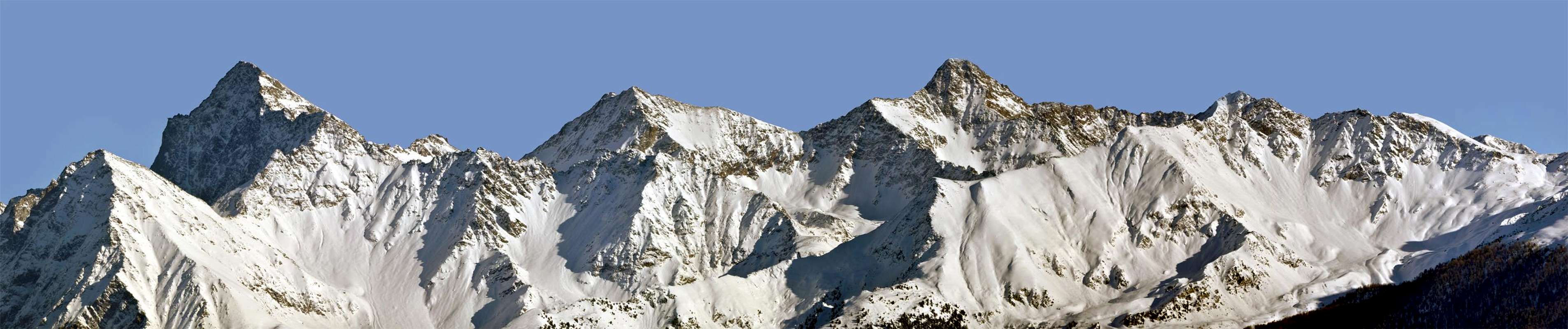
Pic Garin West Wall between North-northwest & South-southwest (is S-shaped) Ridges, right Southern Face & Crest, by Antonio
Once passing, the other deliberately follow the via
To Know
Thursday, July 21th, 1968: Pic Garin North-northwest/North-northwest Edges with variant and traverse to Punta Rossa of Emilius. This time we do not go there for the accident. We are no longer those of the past and the Fellowship is enlarged. Now I even know the Abbé Grégoire Henry and his Guide Comé and I also read their Journey of Exploration in 1902. For two years I joined the C.A.I. and I also attended the Courses Mountaineering. So many things have happened and it is very changed. Attracted to other mountains I have a little forgotten the "my", those of my youth. Hilary is military party from Easter and it is down to the Dolomites and Carnian in Friuli; see him again in October. Meanwhile Gianni Junod, who knows little, I begin to go hiking. In a year die together Aiguille Croux. Fate has strange paths and unsearchable, at least for us men.
I want to go to the Pic Garin to do what Edge North-northwest along which the Abbé had descended. The same is the normal route to the peak date and the first ascent in 1875 by the Military Officer Cesare Pavese 9° Company Alpine Troops with two soldiers, but it is quite probable that this ridge have risen early by the Abbots Chamonin and Chanoux in 1856 starting from Aosta Town. In my previous two climbs snow conditions and, above all, the equipment we had been advised not to follow it does not exist. And then if we did not come down, we will climb. I solo will, because my brother Dario thrilling downhill after that in September 1966 he stopped going to the mountain. He had enough, to him that was enough adventure. Incidentally the Music he loves most. Each to his own way ...
But I am here with three other companions, as well as Gianni, Giorgio Boglione and Giovanni De Paoli, two of his friends. What does not change is the weather situation. As well today, when a little after 6,00 am we start from Pila Resort the weather is bad and the threat of rain. Low clouds and yellowish color like vomiting stagnate at the base of the mountains, crossed and overlapped each other. With scarce desire to go Arbolle, where we arrived at 7.30.
The Garin is covered by big clouds, but in the meantime it is raised a strong wind, which gives rise in us some small hope. Quick, let's go to Col Garin, the wind that greets us is cold and the rocks are covered with sleet. This ridge should not be difficult, even if there is the
"verglass". At the base of the West Wall to
2950 metres it is very cold and even the jacket is not able to mitigate it. We stop to eat: a quick stopover because the storm is very strong and wraps covered mountain with large glacial flows that take on a magical look, almost lunar. Immediately to the left of the small ridges adjacent to climb a very steep small gully. We are not tied and the ground is treacherous, ice, rock and broken hands of Giovanni and my freeze. Gianni makes us a massage with an ointment
"Dolpich", but immediately after a boulder unsafe detaches from his hands threatening to hit others below and make even him fall. Luckily it is only a glancing hit and resumes his balance. With a last step, the most insidious and difficult, we go out on the ridge. The others arrive, enveloped in mist, from what looks like a Dantesque Hell, but uphill. Now everything is easier, even if we have to do the steps with the toe of his boot in the snow very hard in the middle of reddish rocks easy. Now everything is easier , even if we have to do the steps with the toe of his boot in the snow very hard in the middle of red rocks easy . After crossing the two summits, with the sun finally, we go down to 12,00, after pulling the rope through a North-northeast Edge not much in evidence, which divides the North Face of the Wall Northeast and that has never been previously traveled. By means of small walls, ledges with frozen gravels and iced funnels, fast half- time, we are at the base, and after a short climb, we reach the Pas du Valaisan
(3210m), leaving the top left of the same name Mount
(3307m) and then, via the South-southwest Crest climb to Punta Rossa Western
(3401m), the highest. Singular that going from one side of the ridge freezes, while on the opposite it bursts from the heat. At your convenience. Once in the Summit wanted to continue the Emilius, but big black clouds coming force us to retreat. It will be for another time (eight years pass). From the hill on the Western dangerous side, steep and exposed to the fall of stones, on gravels, debris and hard snowfields go down in the Arbolle Walloon, hence to Pila in the usual way.
Sunday August 25th, 1971: Southhwest Ridge, lone, with descent through North Face. Of this my fourth ascent to Point Garin can not find clipboard. Maybe I've lost, maybe I have not written. I find only small notes in my General Ledger. Have patience, I proceed by memory. For the little that is left to me. I remember that this was a bad day with the time that, with the passing of hours, it became increasingly bad with dark clouds that do not bode well. My partner Saverio Cusumano, son of my Doctor Epifanio, not feeling well for the thing which stops at Arbolle, also advising me not to go. The weather gets worse and worse, but I continue anyway. For the third time I go up the Southwest Ridge (the fourth in 1965 because we had made the uphill and then downhill),
in the footsteps of Abbot Henry and Mountain Guide Grégoire 1902, or, if you prefer, Alexander Burgener & English Company in September 1894, but they last had turned back the big Shoulder and at the end had come up to the couloir of the West Wall, abandoning the thread of crest where it becomes more challenging. No, I climb, just like Henry and Comé. I do not remember much of this ascent if not the fact that it was carried out with a rush of the Devil, I pressed on the accelerator because of bad weather. The second reason is that I desire to not leave for a long time in solitude Xavier. Nothing else comes to mind. During the descent, however, I go directly to the North Face of steep fields of frozen snow, thinking they were the first to go there. Instead, the two brothers Falcoz had already passed through here going downhill, after the first winter ascent of December 26th, 1936 carried out through the Southwest Ridge. Their descent was different because, in order not to lose altitude level, had, after the summit triangular stretch, cut diagonally across the face from East to West to reach the ridge between Garin and Mount Valaisan to be able to go to resume the skis below the Shoulder, then back to the West Lake and then to Garin, Arbolle and Aosta with a nice glide by the same. I will go down much more directly, down to the bottom, to the right of the vertical Summit and not far from the North-northeast Edge. A beautiful and fun descent skiing but without crampons and ice-axe, but exclusively with my boots! Then through to the West and it makes me another idea: climb the shattered East-northeast Face of Mount Valaisan, bypassing the same and then go down to the lake and from this towards Garin Hill and Arbolle, where Xavier awaits. I do not remember nothing more except the fact that it starts to rain much and descending from the hill, I see a terrible landslide on the South Wall, almost the Southwest, of the Emilius.
Also this time I have no path down the Route Abbé and Gregory. It will be for another time ...
Giovedì 18 Luglio, 1968: Pic Garin Spigolo Nord-nordovest/Spigolo Nord-nordest con variante e traversata alla Punta Rossa dell'Emilius. Questa volta non andiamo là per caso. Ormai non siamo più quelli di una volta e la Compagnia si é allargata. Adesso conosco anche l'Abbé Henry e la sua Guida Grégoire Comé ed ho letto anche del loro Viaggio di Esplorazione del 1902. Da due anni mi sono iscritto al C.A.I. ed ho frequentato anche i Corsi di Alpinismo. Tante cose sono accadute e molto é cabiato. Attratto da altre montagne ho un poco dimenticato le
"mie", quelle della mia giovinezza. Ilario é partito militare da Pasqua ed é giù per le Dolomiti e nelle Carnie in Friuli; lo rivedrò ad Ottobre. Nel frattempo con Gianni Junod, che appena lo conosce, incomincio a fare delle escursioni Tra un anno moriranno insieme all'Aiguille Croux. Il Fato ha percorsi strani ed imperscrutabili, almeno per noi uomini.
Voglio tornar al Pic Garin per fare quello Spigolo Nord-nordovest lungo il quale l'Abbé era sceso. Lo stesso costituisce la Via Normale al picco e la prima salita data del 1875 da parte dello Ufficiale Cesare Pavese della 9° Compagnia Alpina con due soldati, ma é alquanto probabile che da questa cresta siano saliti i primi, gli Abati Chamonin e Chanoux, nel 1856 partendo da Aosta. Nelle precedenti mie due salite le condizioni di innevamento e, soprattutto, l'attrezzatura inesistente ci avean sconsigliato di percorrerlo. Ed allora se non l'abbiamo disceso, lo farem in salita. Lo farò, perché anche mio fratello Dario dopo quella discesa thrilling del Settembre 1966 ha mollato di frequentar montagna. Gli era bastata quell'avventura. Daltronde lui ama di più la Musica. Ad Ognuno la sua strada ...
Io invece son qui con altri tre compagni; oltre a Gianni Giorgio Boglione e Giovanni De Paoli, due suoi amici. Cosa non cambia é la situazione metereologica. Anch'oggi, quando poco dopo le ore 6,00 partiamo da Pila il tempo é brutto e minaccia pioggia. Nuvole basse e di color giallastro come il vomito stagnano alla base dei monti, accavallate l'un sopra l'altre. Con scarsissima voglia andiamo ad Arbolle, ove arriviamo alle 7,30.
La Garin é avvolta in grandi nuvole, ma nel frattempo s'é alzato un forte vento, che fa nascere in noi qualche speranziella. Veloci, andiamo al Col Garin; il vento che ci accoglie é gelido e le rocce sono coperte da nevischio. Questa cresta non dovrebbe presentare difficoltà, anche se c'é del
"verglass". Alla base della Parete Ovest a
2950 metri circa fa molto freddo e neppur la giacca a vento riesce a mitigarlo. ci fermiam mangiare: una sosta breve perché la tormenta é molto forte ed avvolge la montagna coperta da grandi colate di ghiaccio che assumono aspetto magico, quasi lunare. Subito a sinistra saliam delle crestine attigue ad un canalino ripidissimo. Non siam legati ed il terreno é infido e gelato, la roccia rotta e le mani di Giovanni e le mie gelano. Gianni ci effettua un massaggio con il
"Dolpich", ma subito dopo un masso pericolante gli si stacca dalle mani rischiando di colpir gli altri sotto e di fare precipitare pur lui. Fortunosamente é colpito solo di striscio e riprende l'equilibrio. Con un ultimo passaggio, più insidioso che difficile, usciamo sulla cresta. Gli altri arrivan, avvolti in nebbie, da quel che par 'n'Inferno Dantesco, ma in salita. Adesso tutt'é più semplice, anche se dobbiam scalinar con la punta dello scarpone nella neve durissima in mezzo a facili rocce rossastre. Dopo aver attraversato le due sommità, finalmente con il sole, alle 12,00 discendiamo, dopo aver estratto la corda, tramite uno Spigolo Nord-nordest non molto in evidenza divisorio la Faccia Nord dalla Parete Nordest e che non é mai stato in precedenza percorso. Per mezzo di muretti, cengie con ghiaie, detriti ed imbuti ghiacciati, veloci in mezz'ora, siam alla base e, dopo breve risalita, raggiungiamo il Pas du Valaisan
(3210 m), lasciando in alto a sinistra l'omonimo Monte
(3307 m); poi, tramite la Cresta Sud-sudovest saliamo alla Punta Rossa Occidentale
(3401 m), la più elevata. Singolare che salendo da una parte della cresta si geli, mentre sull'opposta si scoppi dal caldo. A vostro piacimento. Giunti in Cima volevam proseguire verso l'Emilius, ma nuvoloni neri in arrivo ci obbligano alla ritirata. Sarà per 'n'altra volta (passeranno otto anni). Dal colle per il pericoloso versante Occidentale, ripido ed esposto alla caduta di pietre, su ghiaie e duri nevai scendiamo nel Vallone dell'Arbolle, donde a Pila per via solita.
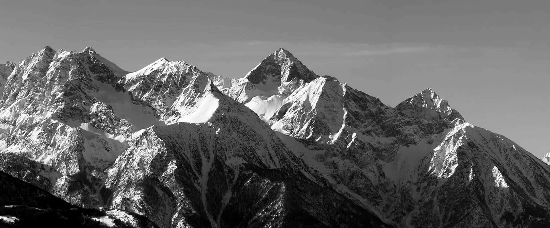
Punta Rossa & Peak Garin above Cappello, Frozen Lochs & Garin Hill in Arbolle Walloon, from Emilius, by andrea.it
Domenica 25 Agosto 1971: Cresta Sudovest da solo con discesa dalla Faccia Nord. Di questa mia quarta salita alla Punta Garin non trovo più appunti. Forse l'ho perduti, forse non l'ho nemmeno scritti. Trovo esclusivamente piccole annotazioni nel mio Registro Generale. Abbiate pazienza, procedo a memoria. Per quel pò che m'é rimasto. Ricordo che anche questa era una giornata con il tempo brutto che, col passare delle ore, diventava sempre più cattivo con nuvole scure tali da non promettere nulla di buono. Il mio compagno Saverio Cusumano, figlio del mio Dottore Epifanio, non si sentiva molto bene per la quale cosa s'é fermato ad Arbolle, consigliando anche me di non andare. Il tempo peggiora sempre di più, ma parto ugualmente. Per la terza volta salgo la Cresta Sudovest (la quarta perché nel 1965 l'avevamo fatta in salita e poi in discesa),
sulle orme del 1902 dell'Abbé Henry e di Grégoire o, se preferite, di Burgener & English Company 1894; ma quest'ultimi avevan girato addietro allo Spallone e nella parte finale eran saliti pel canalone della Parete Ovest, abbandonando la cresta dove diventa maggiormente impegnativa. No, proprio come Henry e Comé. Non mi sovvien molto di questa ascensione se non del fatto di averla effettuata con una fretta del Diavolo, che mi incalzava con questo tempaccio. Il secondo motivo é che non volevo far attendere Saverio per troppo tempo. Altro non mi vien in mente. In discesa però si: scendo direttamente per la Faccia Nord su ripidi campi di neve gelata, pensando di essere il primo a passare da quelle parti. Invece eran già transitati i due fratelli Falcoz in discesa anche loro, dopo la prima invernale del 26 Dicembre del 1936 effettuata tramite la Cresta Sudovest. La loro era stata una discesa diversa perché, per non perdere quota di livello, avevano, dopo il tratto sommitale triangolare, tagliato tutta la Faccia in diagonale da Est verso Ovest per raggiungere la cresta tra la Garin ed il Mont Valaisan onde poter andar a riprendere gli sci sotto la Spallone Ovest e poi rientrare al Lago Garin e quindi ad Arbolle ed Aosta con una bella scivolata tramite gli stessi. Io invece scendo direttamente, e fino in fondo, molto più a destra sulla verticale della Sommità e non molto distante dallo Spigolo Nord-nordest. Una bella e divertente discesa, senza piccozza e ramponi ma sciando tramite gli scarponi! Poi attraverso ad Ovest e mi viene un'altra idea: salire la frantumata Faccia Est-nordest del Mont Valaisan, oltrepassare il medesimo e poi scendere al lago e da questo Col Garin ed Arbolle, dove Saverio attende. Non ricordo altro se non il fatto ch'inizia a piovere decisamente e, scendendo dal colle, vedo una terribile frana sulla Parete Sud, quasi Sudovest, dell'Emilius.
Anche questa volta non ho percorso in discesa la Via dell'Abbé e di Gregorio. Sarà per un'altra volta ...


Comments
Post a Comment