
|
|
Mountain/Rock |
|---|---|
|
|
40.39050°N / 119.5753°W |
|
|
Washoe |
|
|
Hiking |
|
|
Spring, Summer, Fall, Winter |
|
|
7608 ft / 2319 m |
|
|
Overview
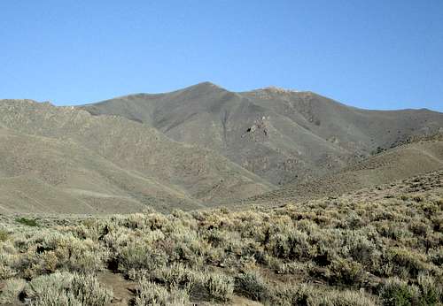
From the east side
Located just south of Gerlach in Northwest Nevada, this is a real gem of a viewpoint, well worth the effort to make the effort to get to the top. It is also a peak that has over 2400' of prominence which secures the 104th spot on the Nevada prominence list and that was the reason I was inerested in getting this one.
The Pyramid Lake Indian reservation is on the west side of the range and it is probable that the summit may be on reservation land although it isn't posted as reservation land at any point. No permit is necessary if you access the peak from the eastern side but one would be necessary to approach it from the west.
The name Pah-Rum is thought to commemorate the Parumpats, a Piute band living at Parum Spring when J.W. Powell and G.W. Ingalls took a census of the indians living in Nevada in 1873.
Getting There
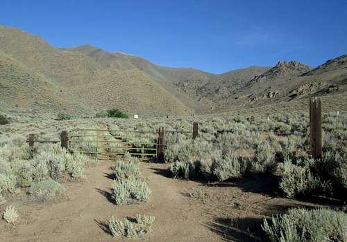
The "Trailhead"
Best approached from I-80 by turning onto Nevada highway 447 and heading north.
We used Dennis Poulin's excellent directions posted on peakbagger.com to find our way to the trailhead:
"I approached from NV Hwy 447 about 60 miles north of Wadsworth. There is a paved road to the west that has a sign indicating US Geothermal 9 miles and Empire Farms 7 miles. Zero your odometer and head west, the road turns to a nice gravel road and then at mile 4.8 turn right onto a paved road again. At 6.4 miles there is a dirt road exiting to the left that almost parallels the paved road. Take this road and stay straight at the intersections. At mile 8.3 turn left at a closed gate, at 8.8 turn right, and at mile 9.4 turn left. At mile 10.5 take the right fork and stay on this rutted road until you reach another locked gate at mile 14.1 and park." This gate is located about 5000' in elevation and is the trailhead.
Route
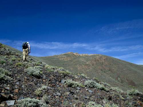
The summit is in sight
Once again, we used Dennis's route description as posted at peakbagger and it was dead on:
"Climb over the gate, and go through the next 2 gates. There is a small travel trailer that looks like it serves as a hunting cabin here, but there was no one around when we went through. Continue hiking up Rattlesnake Canyon until the road ends and then follow cow trails up to where two drainages come together and the east ridge of Pah-Rum separates them. There is a large rock outcropping at the bottom of this ridge. Get onto the ridge and follow it up to the summit. There are a few rock outcroppings to navigate around, but it is not difficult. We went to the left of the largest rocky areas."
I would add that some of the terrain is very steep but the footing is good. Also, just beyond the cabin/trailer, the road and trail to the start of the real beginning of the elevation gain is brushy and in early season you should check for ticks. We noticed cattle activity in the area and wild horses further up.
Our elevation gain from the trailhead at the gate to the summit was about 2600' and about 2.5 miles each way
Red Tape
None that I am aware of although we did encounter the locked gate on what is obviously a private property holding within the BLM land, it was not posted. If you are not sure or comfortable, you can work your way around this area by working around the fenceline until you get onto the road (trail) that heads up rattlesnake canyon. Although the first gate is locked, it is easily negotiated and the other two gates are not locked but be sure to close them behind you.Summit stuff
 East East |  Northeast Northeast |  South South |
As mentioned earlier, the views from the summit were exceptional. I unfortunately ended up with only a few pics that were decent since many others were blurry, which is strange since generally my pics don't seem to have that problem. I have posted the ones that I liked above.
Since 1999, this summit has seen 12 peakbaggers that are chasing prominence peak. Lists of John shows a couple more so all in all, probably 14-15 have been able to check this one off their Nevada to do list. There were other signatures but they were from hunters and locals who enjoy climbing to the top of this one.
 Register Register | Summit  Summit Summit |  Witness benchmark Witness benchmark |
The central benchmark was not found although two witness markers were located. Both pointed to a huge pile of stones on the summit and I did not want to pull all the stones / rocks away to see if the central benchmark was still there.
Camping
We car camped off of the road on the way in and since the BLM allows for car camping as long as you use the "leave no trace" ethics, you can do as we did and find a suitable spot to camp.There is a small motel in Gerlach and more in the Fernley area off of I-80. There are no organized campgrounds in the area.