
|
|
Area/Range |
|---|---|
|
|
35.24674°N / 74.55322°E |
|
|
Mountaineering |
|
|
Summer |
|
|
26660 ft / 8126 m |
|
|
Overview
The Himalaya is the highest mountain range in the world, extending along the northern frontiers of Pakistan, India, Nepal, Bhutan, and Burma and the southern border of Tibet. It contains ten of the fourteen 8000m mountains and is most often associtated with Nepal due to the highest peaks being located there as well as the most climbing activity. The western end of the range is comparitively unknown with the exception of Nanga Parbat which staged some of the greatest climbs in history. Pakistan's Western corner of the Himalaya forms a relatively small portion of the great range however it is just as grand as any part and a great place to visit.The Pakistani Himalaya is located south and east of the Indus River, which originates close to the holy mountain of Kailash in Western Tibet, marking the ranges true western frontier. The river enters Pakistan from India flowing north-west to Skardu. It then continues on this bearing and is joined by the Hunza River south of Gilgit. From here it flows south and west eventually flowing from the Himalayan foothills onto the Indian planes. The Himalaya is a totally separate range to the Karakoram which runs parallel to the north.
One of the remarkable things about the Himalaya in Paksitan is how green and fertile it is compared to the arid Karakoram and Hindukush further north. The Himalaya has a considerably higher precipitation level during the monsoon months creating the environment for rich pine forests and grassy meadows that more closer resemble Canada or Kyrgyzstan than the Karakoram mountains of the Karakoram.
They were formed geologically as a result of the collision of the Indian subcontinent with Asia. This process of plate tectonics is ongoing, and the gradual northward drift of the Indian subcontinent still causes earthquakes. Nanga Parbat stands on the southern tectonic plate while Rakaposhi stands on the northern plate with the Indus River dividing the two. While the Himalaya formed relatively slowly the Karakoram were rapidly pushed upwards resulting in their comparitively dense topography.
The Himalaya is spread across three of Pakistan's provinces. The Northern area encompasses the Nanga Parbat massif and her surrounding valleys, Azad Jammu & Kashmir and extreme south-east corner of the North West Frontier Province (NWFP) include portions of the Lesser Himalaya, also known as the Middle Himalaya. As with the rest of the country the region has a strong muslim identity. Most are Sunnis with some Shi'as in the Astor Valley's upper tributaries. Languages spoken include Shina, Pashto, Hindko and Kohistani however nearly everybody also speaks Urdu. The people south of the Gilgit are contrasting in ethnicity and culture making the region nteresting to visit for this reason alone.
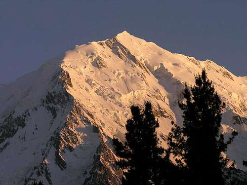 Ganalo Peak from Fairy Meadows
2005 Earthquake
Azad Jammu and Kashmir and the NWFP (in particular Balakot) was hit badly by the earthquake on 21st November 2005 that measured 5.6 on the Richter scale.
Useful links:
BBC South Asia Quake
Earthquake Relief, Rehabilitation & Construction
Pakistan Earthquake 2005
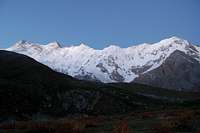
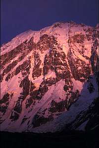
The Nanga Parbat Massif
Sunrise over the Nanga Parbat massif Pt 1 Pt 1 |
 Pt 2 Pt 2 |
 Pt 3 Pt 3 |
 Pt 4 Pt 4 |
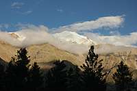
The Pakistani Greater Himalaya is dominated by Nanga Parbat (8125m), the nineth highest peak in the world. Located in the Northern Area province the 'naked mountain' is the western most bastion of the range that stretches 2400km east.
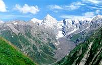
Most people visiting the area either head for the Raikot, Astor, Rupal and Diamir valleys on the north, east, south and west faces of Nanga Parbat respectively. For a region that is only well known for one peak there are a significant number of lofty summits along the 20km long massif. These include Silberzacken (Silver Crag) (7597m), Raikot (7070m), South Chongra (6448m), Middle Chongra (6455m), North Chongra (6830m), Ganalo Peak (6606m) and Mazeno Peak (7100) with its four subsidiary 7000m peaks. A tough trekking route is possible over the Mazeno La located at the western end of the massiv. This links the Rupal valley with the Diamir valley.
Sunrise over the Chongra Peaks
 Pt 1 Pt 1 |
 Pt 2 Pt 2 |
 Pt 3 Pt 3 |
 Pt 4 Pt 4 |
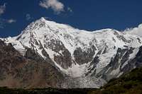
 Nanga Parbat (right) and Silberzaken (left) Nanga Parbat (right) and Silberzaken (left) |
 Chongra Main from Nanga Parbat's Raikot base camp Chongra Main from Nanga Parbat's Raikot base camp |
 Raikot Peak above Raikot Glacier Raikot Peak above Raikot Glacier |
 West Face (Diamir Face) of Nanga Parbat and Mazeno Peak, 7125m (big wall on the right) West Face (Diamir Face) of Nanga Parbat and Mazeno Peak, 7125m (big wall on the right) |
There are also a number of nearby peaks that are relatively easy to climb such as Buldar Peak (5602m), South Jalipur Peak (5206m) and Rupal Peak (5642m). The ease of access and absence of permits required means this is an ideal region for those making their first tentative ascents in Pakistan. Peaks such as these are also suitable for acclimatisation in preparation for higher objectives.
 Rupal Peak inthe Shadow on Nanga Parbat Rupal Peak inthe Shadow on Nanga Parbat |
 Bulder Peak from Fairy Meadows Bulder Peak from Fairy Meadows |
The Kaghan Valley
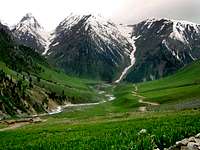
In the NWFP's Hazara district south of Diamir is the 160km-long Kaghan Valley formed by the Kunhar River. The region is renowned for its pine forests, alpine lakes and vast meadows nestled among 4000-5000m peaks. The highest peak in the Kaghan Valley is Malika Parbat (5290m). Peaks in this area are rarely visited by climbers making it an ideal location for those looking to undertake smaller ascents. Spot's such as Chitta Katha Lake are popular with Punjabis however and those looking for tranquillity in such spots should avoid visiting at weekends or during the main summer months.At the valley's head is the Babusar Pass (4175m) which drops down to the small town of Chilas. The pass marks the NWFP's border with the Northern area. This is an rugged, alternative way to travel between the Northern Areas and Islamabad/Rawalpindi. There is no public transport north of the village of Naran and a Jeep must be hired to cross the pass. The Babusar pass regularly blocks, particular after heavy rainfall. There are also a number of good treks in the region, some of which cross in to the AJK province and back.
 Malika Parbat Malika Parbat |
 Makra Peak Makra Peak |
Azad Jammu and Kashmir
 The Kashmir Valley
To the south and east of Diamir and the Kaghan Valley is the Azad Jammu & Kashmir (AJK) province that extends along the Pakistani-Indian border encompassing the beautiul Pir Panjal range.
Azad Jammu & Kashmirs highest peak is Sirwali Peak (6326m). It is located at the extreme end of the extremely beautiful Shaunter valley. Beyond this mountain is the Astore and Diamer District of Northern Areas. The greenery ends here and Astore and Diamer are mostly dry districts because Nanga Parbat massif provides the rain shawdow for the Northern Areas and blocks the passage of Monsoonal rain in Northern Areas causing these vapurs to fall in Azad Kashmir resulting in lush green Shaunter valley.If we rightly follow this mounatin ridge it will ultimately take us to Nanga Parbat (8126m). Nanga Parbat is approximately 25 to 30 km air distance from this area. (Info with thanks from MountainLover)
Currrent situation regarding entry to Azad Jammu & Kashmir
For those considering a trip to Azad Jammu & Kashmir the areas of interest to climbers such as the Pir Panjal range are unfortunately off-limits due to the proximity to the line of control. Mountains further south are also off-limits. This is due to the 16km security zone that buffers disputed border.
Anyone planning to visit AJK needs to obtain a No Objection Certificate from the Ministry of Kashmir Affairs & Northern Areas in Islamabad. To obtain this you must provide a letter explaining the areas you wish to visitand the dates of you visit. 2 passportport photos and photocopies of you passport and visa are also required. You may also be asked to provide an additional letter from your embassy or high commission to verify you are who you say you are. The process is likely to be long winded and in the end they may simply say no.
 Sirwali Peak (6326m) Sirwali Peak (6326m) |
 Hari Parbat Peak Hari Parbat Peak |
 Nameless Peaks around Sharda Nameless Peaks around Sharda |
Deosai Planes
 The Deosai Planes
The Deosai Planes are not part of the Himalaya. They are a high altitude grassy plateau between the Himalaya and Karakoram located south and west of Skardu bordering Indian controlled Kashmir. Nowhere is lower than 4000m. The area is unihabited and only accessible for 4 months of the year between June and September. The region is protected under the 3630 sq km Deosai Plain National Park which is the second largest national park in the country after the Central Karakoram National Park. There is a significant brown bear population within its boundaries which and also support the endangered snow leopard and Indian wolf. Himalayan Ibex, golden marmots and snow trout are numerous. A jeep trail stretches from Skardu to the Astor valley. There is no public transport. A jeep from Gilgit to Skardu takes about 16 to 18 hours stopping overnight in Astor. Many people also walk or cycle the trail. Due to its rolling topography it is not a region noted for its mountaineering potential.
Getting There
 The Chongra ridge line above Tarashing
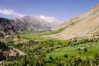 The Rupal Valley
Islamabad is the international gateway for those arriving by air. Emirates also fly to Lahore and Peshawar however Islamabad is in close proximity to the start of the KKH and also has onward flights to Gilgit. Karachi in the south of Pakistan is sometimes cheaper to fly to with connecting Karachi to Islamabad flights costing Rs50,000.
From the south
PIA opperate daily flights between Islamabad and Gilgit the largest town in the Northern Areas. Seats sell quickly and it is advisable to book as far ahead as possible. Tickets can be booked on line or at international or national offices.
Daily buses travel between Pir Wadhai bus station in Rawalpindi and Gilgit along the KKH. Buses pass through Mansehra (change here for Muzzafarabad and the Kaghan valley), Besham (change here if heading to/from Swat or Chitral) and the Indus Kohistan region and eventually Gilgit. The Northern Areas Transport Company (NATCO) is the largest company and has several services a day. Masherbrum Tours and the Silk Road Transport Company also run several buses. Book seats early else you will have the joys of experiencing a night with no sleep on the back seat. The 573km trip takes atleast 14 hours. When I travelled this way last summer the journey took 20 hours. Due to tribal tensions in the Indus Kohistan region buses were travelling through this area under armed convey leading to long delays prior while all buses that had departed from Pindi arrived to form the convoy.
For Muzzafarabad the bus ride from Pir Wadhai bus station in Rawalpindi, via Murree, takes about 4 hours. Regular buses also link Muzaffarabad with Mansehra on the KKH.
From China & the north
Buses cross the border from China daily. The journey from Tashkurgan to Sost takes the best part of a day with a further half day required to continue to Gilgit. For those short of time the journey could be done in one day by hiring a vehicle from Sost to Gilgit however this would meen travelling down the KKH in the dark which would be a shame.
From India
A fortnightly bus service started on April 7th 2005 between Srinagar and Muzaffarabad however, it is not available to foreigners. Only Indians and Pakistanis can take the bus. For those crossing from India the border crossing of Wagah, east of Lahore, is still the main point of entry.
Red Tape
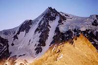
 West wall of Mazeno, subsidiary peak on Nanga Parbat
Visas
A valid visa is required. Visas are NOT issued at the airport and must be obtained prior to arrival. Some embassies such as those in Central Asia are reluctant to issue visas and advise you to obtain them from your home country. A single-entry tourist visa is valid for 3 months from the date of arrival in pakistan and for 6 months from the date of issue. Some visas are only valid for 3 months from the date of issue so check if necessary when applying. Visa prices vary. Americans pay the most for their visa whilst Japanese get theirs free! Visa extensions and reentry stamps used to almost impossible to obtain however the process has become remarkably easier in the last few years. Gilgit DC is a good place to try.
Permits
The Nanga Parbat region is not in a restricted zone and no trekking permit is required. The 16km security zone along the Pakistani-Indian border is totally off-limits to foreigners. For permits in the Azad Jammu & Kashmir province see the above section dedicated to this subject.
Climbing Royalties
The Ministry of Tourism has decided to maintain the 50% reduction in mountaineering royalty fees for peaks above 6500m during 2009. Royalties per expedition are based on a party of 7. Persons additional to this number will be subject to an additional royalty fee. Current royalties are listed below.
| Peak | Normal Fee | Fee for 2009 | ||
| Royalty per expedition | Additional royalty per person | Royalty per expedition | Additional royalty per person | Nanga Parbat | $9000 | $1500 | $4500 | $750 | Silberzacken, Nanga Parbat N, Nanga Parbat NE, Peak 7745 | $4000 | $500 | $2000 | $250 |
| Rakhiot Peak, Mazeno Peak A | $2500 | $400 | $1250 | $200 |
| Chongra Main, Ganilo | $1400 | $200 | $700 | $100 |
| Peaks up to and including 6500m | $1400 | $200 | No fee | No fee |
For peaks below 6500m no royal fee is currently payable for 2009. Prior to the discounted royalty fees all peaks between 6000 and 7000m were subject to a $1500 royal fee with additonal royalties of $200 per additonal member.
When to Climb
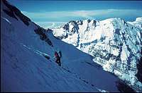 Making the traverse from C III to the Bazhin shoulder (rocky ridge just in front) in the way to C IV. In the rear side is the summit and west face of Mazeno Peak
The mountaineering season starts from late May and finishes by September. July and August are considered the best months to climb in Pakistan. Outside these months snow can be problematic at high altitude. Winters are extreme and climbing highly unrecommended. Of the seven 8000 peaks climbed in winter none have been in Pakistan.
Climbing Conditions
 Hermann Buhl on Nanga Parbat
For many people visiting Pakistan's Northern Areas for the first time the warm summer's take time to adjust to. In Gilgit temperatures regularly stay in their 30s during the summer and whilst it is cooler in the mountains it can still be uncomfortable at times. On days where there are no clouds a single layer will surfice and measures need to be taken to prevent sun burn. Weather can change quickly with fresh snow falling at any time in the year or heavy rains at lower altitudes. Come prepared for a range of climates.
Nights are generally warmer during the climbing season compared to destinations such as the Pamir, Tien Shan or Napalese Himalaya and an early start when climbing is usually imperative to avoid soft snow in the afternoon.
Maps
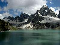 Chitta Katha Lake
  View towards Raikot Valley from the Mazeno Pass
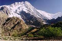 Nanga Parbat from Latabah camp
Nanga Parbat Region
US AMS 1:250,000 topographical map for Gilgit (NI 43-2)
Alpenvereinskarte 0/7 Nanga Parbat/Astor topographical map (1:50,000)
There is also a rare German map (1:50,000) produced in 1936 however this is close to impossible to find
Basic online map showing the main peaks along the Nanga Parbat massiv. Website in French.
General map of Pakistan
Map Stockists
UK
The Map Shop
Stanfords
Cordee
USA
Chessler Books
Map Link
Omni Resources
Germany
Aree Gaul
Deutcher Alpenverein
GeoCentre ILH
Italy
Liberia Stella Alpina
Camping
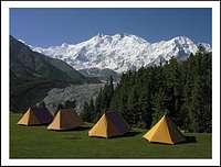 Nanga Parbat from Raikot Sarai Camp
There is generally no charge for camping.
The exception is Raikot Sarai where there is a camping fee of Rs80. Tents can also be rented for Rs350-400 and small huts are available for Rs1200. The adjacent Green Land Camping Ground offers welcome shade but lacks the glacier views.
There are a number of designated camping areas in the Deosai Plains open in the summer at Ali Malik Mar, Shatung, and Chogo Chu (Bara Pani) where tent rentals and meals cost Rs250-350.