
-
 10033 Hits
-
 85.87% Score
-
 21 Votes
|
|
Mountain/Rock |
|---|---|
|
|
37.46270°N / 82.54232°W |
|
|
Pike |
|
|
Hiking |
|
|
Spring, Summer, Fall, Winter |
|
|
1540 ft / 469 m |
|
|
Overview
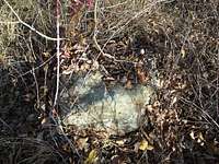
 Outcrop just west of summit
Peach Orchard Mountain rises southwest of the town of Pikeville, above the Levisa Fork of the Big Sandy River. It is heavily wooded in dense stands of hardwoods with a few spindly pines. Though small in stature at only 1,465 feet, Peach Orchard Mountain has a few claims to fame.
• In an area where much of the land sits in private hands, Peach Orchard is one of few Pikeville area peaks accessible to the public.
• Just below the summit sits the tower for WJSO-FM Pikeville. This is a massive red-and-white repeater structure.
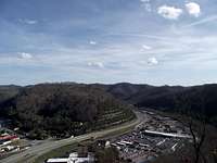
• The Pikeville Cut-Through, one of the largest earthworks in the western hemisphere, slices through the far north-northeastern arm of Peach Orchard Mountain. The earthworks can be admired – or cringed upon by the taxpayer – from an overlook on the northeast slopes of the mountain.
• It overlooks the town of Pikeville (population 6,400) which, like the Fourteener Pikes Peak in Colorado, was named after soldier and explorer Zebulon Pike.
The views from the top of this mountain are not grand (visit the cut-through overlook after summiting for views) but a stroll to the summit makes for a nice, family-friendly outing in the hills of Kentucky.
KY Rank: Unranked
Prominence: 160 feet
Rank & Prominence: href=http://www.listsofjohn.com/PeakStats/Climbers.php?Id=131232>Lists of John
 East-Northeast toward Pikeville
 About the Cut-Through
About the Cut-Through
“In October 1987, Pikeville completed one of the most ambitious engineering efforts east of the Mississippi River. It was a $77.6 million federally funded cut-through project designed to eliminate frequent flooding, relieve traffic congestions, and alleviate the critical shortage of level land in the downtown area.
The Levisa Fork was diverted from its looping course through the city into a half-mile-long cut through Peach Orchard Mountain. Railroad tracks and streets were rerouted from the area and bridges were removed. The former river channel was filled in with dirt and rock from the cut-through.”
Source: City of Pikeville Website
 South from observation cage South from observation cage |  Observation Cage Observation Cage |  Northeast across the cut Northeast across the cut |
Getting There & Route Information
 Ascending old road bed
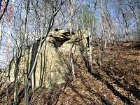 Nearing the summit
 Approaching the radio tower
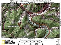 Route Map
 Old roadbed to summit
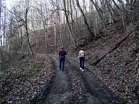 Ascending Peach Orchard Mountain
The trailhead to reach the top of Peach Orchard Mountain is located in Bob Amos Park west of Pikeville, Kentucky. From US Hwy 19, exit to KY Hwy 1384 westbound. Shortly after crossing the river and the railroad tracks, turn south on Bob Amos Drive. Follow the park road all the way to the end of the valley. Instead of taking the sharp left and continuing up the paved road to the cut-through overlook, park near the ball fields.
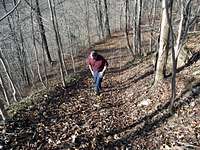
The gated dirt road, closed to unauthorized vehicular traffic, is your path to the summit. Leave your vehicle and walk the main park road briefly to the dirt road gate. Continue through the pedestrian stile and ascend the road through a mix of switch-backs and straight-aways to a saddle where the road forks. Follow the main road to the south toward the large white-and-red radio tower. Continue past the tower and look for a very faint old road bed to your left which will carry you past a rock outcrop to the summit.
Roundtrip Distance: 1.5 miles
Elevation Gain: 500 feet
Red Tape
 Looking up at the radio tower
 On the summit
While not officially part of the Bob Amos Park, Peach Orchard Mountain is unofficially enjoyed by residents of and visitors to Pikeville, “the City that Moves Mountains.” Do not approach or tamper with the communications structures near the summit.
Camping & Lodging
 Peach Orchard Mountain Summit
The Pikeville RV Park is located within Bob Amos Park. The RV park features 21 sites with full hook-ups, cable television and wireless internet.
There are several inexpensive Mom & Pop type hotels in Pikeville as well as a few chains. The two nicer hotels in town are the Hampton Inn and the Holiday Inn Express.
Weather & Seasons
| Typical of the Southern Appalachians, Spring & Fall are the most pleasant seasons to visit Peach Orchard Mountain. Spring will bring blooming ground cover, though rain is quite likely. Fall brings crisp, cool air and brightly colored foliage. Summer can be oppressively hot and humid, while winter can be cold, gray and damp. |