
|
|
Mountain/Rock |
|---|---|
|
|
43.92050°N / 114.6698°W |
|
|
10126 ft / 3086 m |
|
|
Overview
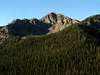
Peak 10,126 is an unnamed summit that that lies in the Boulder Mountains of central Idaho.

Peak 10,126 is the western most of the 10,000'+ mountains in the Boulders. It is quite a rugged peak with an impressive north and west face. Peak 10,126's summit ridge is nearly 3/4 of a mile long and nearly uniform in height making its actual summit discernable from the Big Wood River Valley below.
Few people ever climb to this peak, mostly because of its insignificance in height and prominence. However, the rugged beauty of this peak makes it a wonderful destination for the avid peakbagger.
The least technical and most logical route is a traverse from the summit of Gladiator Peak. The most direct route is from Highway 75 but includes prolonged class 3 climbing.
 |  |  |
Getting There
If planning on traversing from the east, please see information on climbing Gladiator Peak.
For access to the South Ridge Route, drive north of Ketchum and Sun Valley, Idaho. After 32 miles you will pass Galena Lodge on the right. Continue past the lodge and begin to ascend Galena Pass. About 2.4 miles past the lodge, the road will begin to make a large loop to the west, at the apex of a loop is a small, unnamarked road that leads up Horse Creek.
Take this very faint road that quickly crosses an unnamed stream that may be difficult in high water and continue. The road, although not rough, is very old and obviously no longer maintained. A high clearance vehicle is needed because of the very high grass in the median.
A four wheel drive vehicle will be required after about .3 of a mile, which at this point the road fords a dry creek bed. The road continues but ends shortly with very little area for a turnaround.
 |
South Ridge Route
From the end of the access road up Horse Creek, climb directly east up the forest above. Although steep, there is little brush making it an enjoyable warm-up to the south ridge.
Once at the ridge crest, there are scattered remains of an old trail, do not take this as it fades in and out and leads know where.
Turn north and head the sub-alpine forest until reaching the 9,400' contour line. From here, begin scrambling up some fairly loose rock to the prominent summit ridge of Peak 10,126 above. At this point, climb up and over the first tower heading east-northeast.
The ability of your parties scrambling techniques will determine whether you climb over or skirt below the second tower along the ridgeline. If you decide to climb over, expect some class III climbing on fairly sturdy rock.

It is slow going for the next half-mile to the summit as the ridgeline is quite rugged and even traversing below to the east is quite time-consuming.
Two more obvious towers that reach over 10,000' block the ridgeline before the summit. The first tower is continuous class three climbing with little exposure but it is recommended to bypass the second tower 100' below the crestline to avoid some sketchy class IV terrain.
Continue past the second tower and re-gain the south ridge below the summit. At this point, the ridgeline is still quite rugged but is climbable for everyone. Two difficult class III moves may make cautious climbers want to traverse below on the eastern side just before reaching the true summit of Peak 10,126.
The rocky summit offers rewarding views of the Smokies and Sawtooth Mountains.
 |  |  |  |  |
Red Tape
No permits or red tape required.
The access road is closed during winter.
When To Climb
Peak 10,126 is usually snow free by early-July and remains dry through October.
Beside the occasional extreme avalanche danger, a climb during winter should not be to difficult. Its close proximity to the highway allows easy access year-round.
Camping
Camping would be possible along the access road, albeit without any facilities whatsoever.
Many campgrounds are located along Highway 75 including, Prarie and Baker.
Mountain Conditions
Although there are no majoy weather recording stations in the area, the Galena,
The NOAA Pinpoint Forecast will provide excellent future forecasts for the area.
And for recent field observations from the area be sure to check out the Idaho Outdoors Forum.