
|
|
Mountain/Rock |
|---|---|
|
|
39.64426°N / 120.06925°W |
|
|
Sierra |
|
|
Hiking |
|
|
Fall, Winter |
|
|
7062 ft / 2152 m |
|
|
Overview
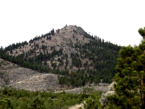
Zoom shot of Balls Canyon Pyramid from the east
Peak 7062 or Balls Canyon Pyramid, is a conical mountain in the northern Sierra front rising steeply above the south side of the Longs Valley. Located west of Cold Springs, NV, it is actually only about 15 miles northwest of Reno, Nevada as the crow flies. The starting point is only about 20 minutes’ drive from downtown Reno.
Balls Canyon Pyramid has a prominence of approximately 640’. The views from the summit are quite nice, although other mountains block an all-encompassing view.
There are two challenges to hiking Balls Canyon Pyramid, both related to access. One of those challenges is that the road that leads to the summit is behind a locked gate. The other is that the roads to the summit go through private land that blocks direct access.
The area is part of the Hallelujah Junction Wildlife Area and is regulated by the California Department of Fish and Wildlife. The area is a haven for wildlife, including Golden Eagles, red-tailed and rough legged hawks.
The road is closed to the public from February 1 through June 30th. In a dry January, it is quite possible to hike up Balls Canyon Pyramid. Although, based on the restriction the ideal time to hike here would be October through late November.
Getting There
From Reno head north on US 395 to Bordertown on the California/Nevada line. Take exit 83 and take a left on Village Parkway. Take a right and follow the road as it crosses train tracks and heads back south. Once you turn south drive another 650 yards and you will see a locked gate on the right. This is Balls Canyon Road. Because the road is behind a locked gate, you have to start here.Route Information
I recommend taking a mountain bike if don’t want to hoof it for three miles up to the access road. A 2WD car could easily make it these three miles.Three miles up the road, take a right up a side road. This is before you see a gate on Balls Canyon Road that signifies the start of private land. You either need to drop down to your left and cross a creek, or head up the access road on the right and continue past the private land.
If you drop down and cross the creek, you will have to cross a fence. It is harder to stash a bike here, but you can always stash it on the access road to the right.
Once up on the other side of the creek, Balls Canyon Pyramid is straight ahead of you. From the access road, it is about 1.5 miles and 1,600’ to the summit.
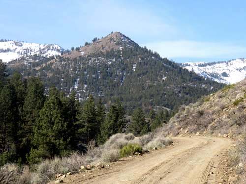
Balls Canyon Pyramid from Balls Canyon Road
From Balls Canyon Road, the one way hiking distance is 4.5 miles, gaining about 2,000’.
There is a longer route, where a road goes to within a tenth of a mile of the summit. To avoid the private land, stay on higher ground to the right, pass the house on Balls Canyon Road and after a half mile, drop back down to Balls Canyon Road. Take the first right and take it as it heads into a meadow. Take this road for one and a half miles, at which point it heads back to the east. Hike up the road for a little under a half mile, and another road on the left heads up towards Balls Canyon Pyramid. The road peters out after about three-quarters of a mile, at just 250’ below the summit.
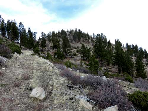
Looking up at the summit from the backside road
From Balls Canyon Road, the total one way hiking distance via this longer route is 7 miles, gaining about 2,000’.
Red Tape
Per the notice in the Overview, the Balls Canyon Road is currently off-limits to hikers, bikers, or any visitors besides the residents of the road from February 1 through June 30. A little over three miles up the road, sadly there is a section of private land with a “No Trespassing” Sign. The individual or individuals who own this property have blocked off this area, even though they are blocking access to Forest Service lands.If you cross the creek, I do not believe you will see “No Trespassing” signs, but I cannot guarantee. I have hiked up the south side of Balls Canyon Pyramid and there were only restrictions near the houses. But given the proclivity of landowners in the area to try to restrict access, it wouldn’t surprise me for you to come across a sign.
If you want to be totally safe, just head to the meadow up the longer route. Stash your bike after three miles if you want to make it easier, then stay on the right side of the road above the house, and just drop back down once you pass the second “No Trespassing” sign. Once you pass the second sign, you are back on Forest Service lands. If not for this one landowner blocking access for 1/2 miles, the path would be quite easy, and you could bike most of the way.