
|
|
Mountain/Rock |
|---|---|
|
|
47.73950°N / 84.8692°W |
|
|
Algoma |
|
|
Hiking |
|
|
Spring, Summer, Fall, Winter |
|
|
1699 ft / 518 m |
|
|
The Mountain...
Peat Mountain sits in the northern reaches of Ontario's Lake Superior Provincial Park on the eastern shore of Lake Superior. The mountain takes its name from a moss known as Sphagnum, more commonly known as Peat Moss which is very common in the lowland bogs surrounding the mountain. It is a small yet remarkably rugged peak in a region blanketed in small, remarkably rugged peaks. It is old as well, very old. The mountain is part of the massive 3 million square mile Canadian Shield. The shield is comprised of rock over 1.5 billion years old, some of the oldest exposed rock on the planet. Once upon a time Peat Mountain was part of a massive mountain range but over the eon’s erosion and periods of glaciation have worn the landscape down to the present conglomeration of countless rocky knobs and lakes. It’s a wonderfully rugged country.It’s an empty country too. Only around 5,000 people live within an hour and a half of the mountain. Sault Ste. Marie (pop. 75,000) is the closest town of any consequence and is 2 hours to the south. The closest town with more than 200,000 people is Grand Rapids, MI almost 500 miles away!! You get the picture, its remote.
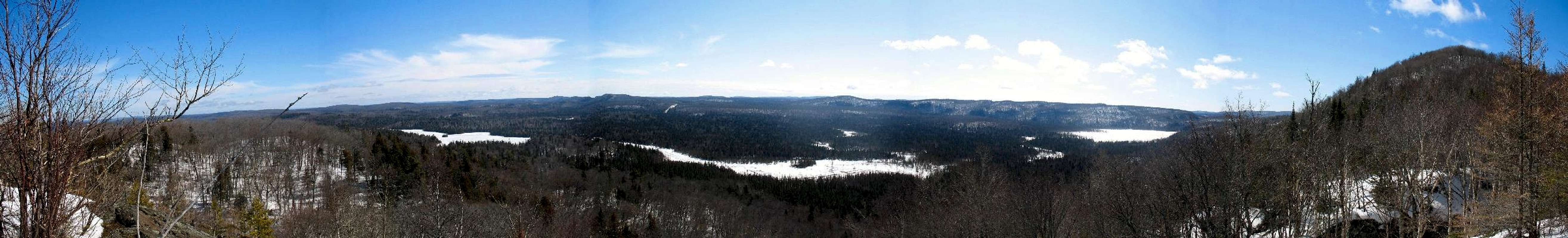
The mountain itself stands just over 1600 feet tall though an exact height is not listed for it. The peak is heavily forested. Lowland areas around the mountain are dominated by Cedars and other conifers while the upper slopes of the peak are covered in beautiful stands of Birch and Sugar Maple. Despite the thick covering of trees the mountain has several wonderful viewpoints from bare rock outcrops that allow you to enjoy many stunning panoramas of the surrounding wilderness. There also looks to be any number of opportunities for scrambling along many of the surrounding ridges. The rugged beauty of the hills and lakes in this area makes Peat Mountain a very special place to visit.
  |
Lake Superior Provincial Park...
 Welcome...
Lake Superior Provincial Park was created in 1944 and encompasses 600 square miles of wilderness on Lake Superior’s eastern shore. The park is home to hundreds of nameless rocky peaks, beautifully clear lakes, stunning headlands, and the cliffs of Agawa Canyon. The park sits about 2 hours north of Sault Ste. Marie, just south of the remote northern town of Wawa (famous for its big goose). The park sits atop the aforementioned Canadian Shield and was once an active volcanic area. Today the rocky landscape sits on the transition zone between the northern boreal forest and the hardwood forests to the south. Traveling through the park stands of maple and birch give way to spruce and cedars the farther north one travels through the park.
The park is home to a wonderful variety of northern woodland creatures. These include but most definitely are not limited to the Moose, the White-Tailed Deer, the Woodland Caribou, the Black Bear, the Eastern Timber Wolf, the Canada Lynx, the Beaver, Marten, and Fox. Over 150 species of bird also make their home in the park.
The park is primarily wilderness. Much of it is inaccessible by road. Highway 17, better known as the Trans-Canada, bisects the park from north to south. At each end of the park are small, modern campgrounds. The southern one is at Agawa Bay while the northern one Rabbit Blanket Lake sits at the foot of Peat Mountain and is the access point for the peak. Elsewhere throughout the park are scattered something like 175 backcountry campsites that are accessible only by foot or canoe.
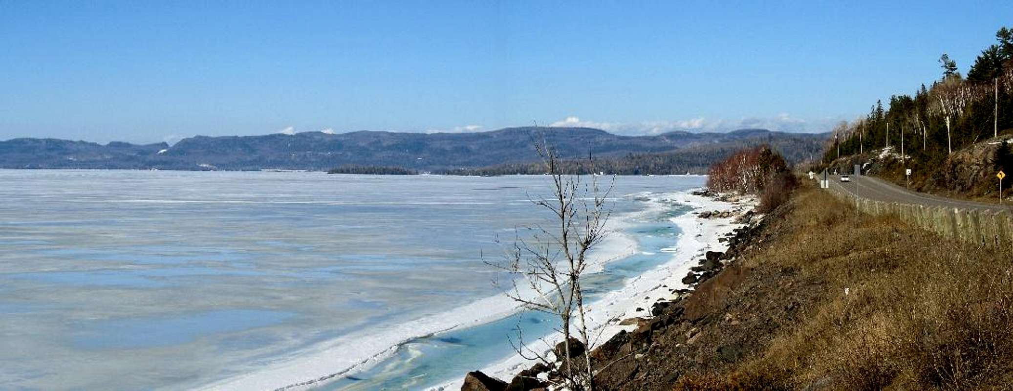
 Old Woman Bay
Peat Mountain is one of many natural and historical attractions within the park. Just to the north of the mountain is beautiful Old Woman Bay whose rocky beach is flanked to the south by cliffs 600 feet high. At the opposite (south) end of the park are the famous Agawa Rock Pictographs. Here numerous images, painted by the Ojibwe people 150-400 years ago, are visible along the lakeshore cliffs. Aside from Peat Mountain the park also contains about 80 additional miles of trail including one that I am dying to explore, the 40-mile Coastal Trail. This extremely rugged trail follows the jagged Lake Superior shoreline from Agawa Bay north to the remote Chalfant Cove at the parks westernmost extremity.
Trails & Camping...
 View from the Trail
 Birch
BirchRabbit Blanket Lake Campground sits below Peat Mountain and is a fully-equipped modern campground. It is open from May through October has 60 sites, showers, washing machines, flush toilets, and a small swimming area with boat launch. In the backcountry you only have the choice of a lone campsite at Foam Lake a little over 3 miles from the trailhead. In 2007 a site at the modern campground will cost you $25-$30.
Red Tape & When to Go...
 Frozen Rabbit Blanket Lake
While there are no fees to simply drive through the park, if you plan to get out of your car and spend a day or two on the trail you’ll have to pay some money. For day hikers a vehicle permit will cost you $11 per vehicle. If you plan on staying in the backcountry you’ll instead have to pay $8.50/person/night ($4 for kids 6-17 yrs). There is one sure-fire way to avoid these fees…visit in the winter. Between November and April there are no facilities available in the park and you can visit for free. This leads me into when to go…
Needless to say winter along the shore of Lake Superior can be a bit rough. A winter where 200 inches of snow falls is considered a “mild” one. Temps near the lake tend to be a bit milder than inland locations but considering 5 above much “milder” than 5 below is a matter of opinion. Hardly surprising is it then that winter sees very few people visiting the mountain or the park. If the elements don’t bother you and you can catch an elusive clear day the solitude of the winter season in this region is amazing. Spring (that short season the last week of May) can be nice if you can make it between snowmelt and the bug season. Summer is the busiest month and the buggiest. The swarms of mosquitoes and Black Flies tend to die off by late July (-ish) and temps at this northern lakeshore location can be very refreshing. “Refreshing” here can also mean 50-degrees in July, though, so be prepared. Autumn would likely be my choice of months to visit. The summer crowds will have tapered off and the crisp days and cool nights along with the blazing orange of the maple forests is amazing.
The mountain is easily accessible in all seasons because the trailhead is only a couple hundred yards off the highway. Even so, regardless of what season you plan to visit, be prepared for the worst. You are visiting the Lake Superior region. Anyone who’s spent any time around this lake will tell you it can snow in September, frost in July, or rain in December.
Getting There...
For those of you who don’t live in Wawa the trip to Peat Mountain would probably be a bigger adventure than the climb itself. I’m going to go out on a limb and assume most people will be arriving from the south. This means you will have to pass through the twin cities of Sault Ste. Marie, Michigan and Ontario.-From the United States: Get yourself to Interstate 75 and simply follow it north until you arrive in Canada. Once in Canada follow the Trans-Canada (Highway 17) north/west towards Thunder Bay. The highway north of the Soo is extremely scenic. On my trips up to the park I always end up burning extra hours stopping and exploring the rivers and beaches. You will enter Lake Superior Provincial Park about 120 km (75 mi) north of Sault Ste. Marie. Keep on Hwy. 17 for about another 64 km (40 mi) and watch for the entrance to Rabbit Blanket Lake Campground on your left. The trail starts from near the entrance to the campground.
-From eastern Ontario: The obvious route to the park is via the Trans-Canada. Whether you’re coming from Toronto or Ottawa you’ll make your way to Sudbury and then follow the Trans-Canada another 300 km (186 mi) to Sault Ste. Marie. From Sault Ste. Marie follow the directions above…
Enjoy the drive!!!
 |
Links of Interest...
Lake Superior Provincial ParkFriends of Lake Superior Provincial Park - Visit the "Publications" link on their website to order a great topographic trail map of the park. The map is displayed in both 1:100000 and 1:63000 scale and shows all foot and water trails within the park. It's a bargain at only $5.00!
Wawa Weather (The Weather Network)
Canadian Topo Maps
DWhike's Adventures - Shameless self promotion...come visit my website for more pics of Peat Mountain and other places that I have wandered off to in recent years...
