
-
 6062 Hits
-
 82.68% Score
-
 16 Votes
|
|
Mountain/Rock |
|---|---|
|
|
47.77619°N / 121.60691°W |
|
|
King |
|
|
Hiking, Scrambling |
|
|
Spring, Summer, Fall |
|
|
5360 ft / 1634 m |
|
|
Overview
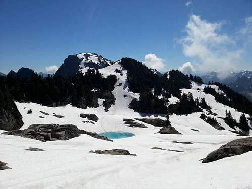
Persindex is a must grab for peakbaggers attempting the Persis-Index traverse since it has over 440' prominence and presents a 1,000' challenge on it's own just traveling through on the easiest route. Heck, it's a great destination for those wanting just a little more after Persis with much more reward. A very faint trail that starts near the summit tarns on Persis drops South across talus and meadows past five large gendarmes then up a snowy or rocky gully beyond the furthest of the gendarmes to a flat area at 5,200'. It is not the easiest peak to get to and will require some route finding even later in the year. In early season the snowy peaks in their proximity to civilization is a cool sight and especially amazing during a moonlit evening. In autumn blueberry bushes provide a great red blanket over the rocky pillars with Puget Sound and the Olympics as a gorgeous backdrop.
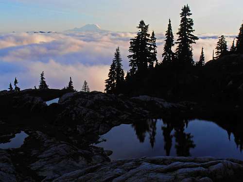
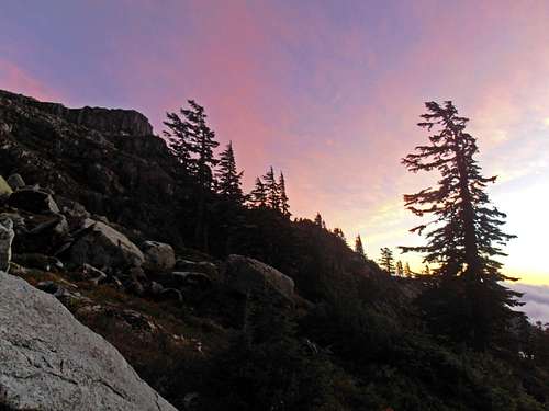
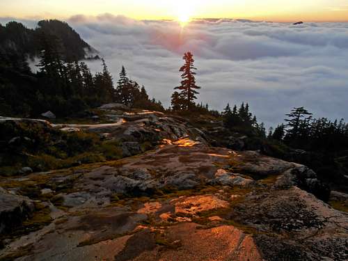
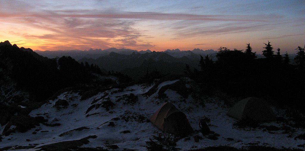
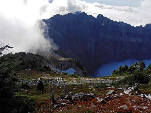 Persindex from Index | 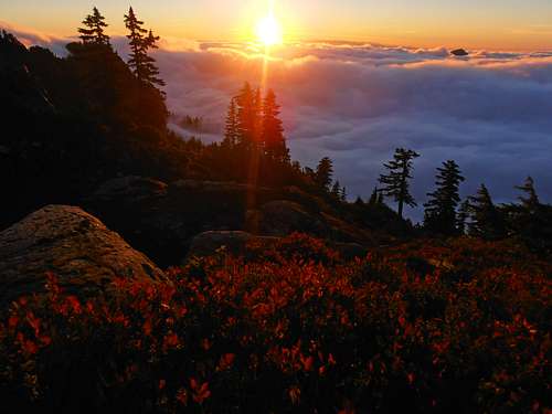 Sunset on a sea of clouds |
Getting There
 3,075' unmarked Persis Trail-head | For the Mt. Persis Approach: Take US highway 2 to FS 62 (a.k.a Proctor Creek Road) and follow its gentle grade for 3.3 miles to an obvious but unmarked junction. Take the left fork which is the ever deteriorating FS 6220. High clearance vehicles will find no trouble but otherwise use your best judgement and stop when it gets too rough. Follow this for another mile or so taking yet another left fork onto a spur road at a brown sign with shotgun holes in it. At the last and final junction is a sharp and steep left just before a waterfall. Continue a third a mile to a pullout and keep your eye out for a hole in the forest on the up-hill side. This is the unmarked trail-head for Persis and can be difficult to spot in low light as the road continues a little ways beyond it. The Mt. Persis trail starts very steeply then eases up as it moves through first growth forest then old growth and finally the summit tarn area. For the Proctor Creek Approach: From FS 6220 drive 1.1 miles to the sign with the shotgun holes and stay right. Continue driving until FS 310 on your left, which may not be marked but heads East-SE following Proctor Creek. The road becomes un-drivable quickly as the forest is reclaiming it's lost property. Have fun negotiating all the brush, cliffs and waterfalls on this one. |
Routes
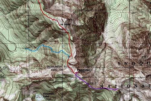 Persindex Route Map | Mount Persis (RED): Climb Mt. Persis to the summit tarns and bear South aiming for a large boulder/talus field. Move down and left to access easy meadows where careful inspection will reveal a faint trail. In winter this terrain will be easy without a trail. Stay below the cliffy gendarmes and don't be tempted to climb up easy gullies or ramps too early as you will be cliffed-out. Navigate around a prominent ridge that will lead to a small valley with a creek running through it that will have snow most of the year. This crosses the county line and takes you to the summit plateau where either snow or tarns awaits you depending on the time of year. The summit is to the east and is krumholtz covered class 2/3 with a death fall . Proctor Creek (CYAN): Dodge the all-too-easy Mt. Persis trail-head and start at the end of FS 310 from FS 6220. Follow Proctor Creek's main drainage until an impassable waterfall. Hop over to the right side of the falls and bash brush very steeply up secondary growth forest littered with remnants of old logging operations. Stumps are generally a good sign you found a reasonable route. Nothing about this one is easy though, so pull yourself up by the slide alder/huckleberry/devil's club and tough it out. Eventually you meet up with the Persis route at the bottom of the little valley. I strongly recommend bringing cowhide gloves for this route due to all the thorny veggie belays. Persis Index Traverse (PURPLE): Follow this according to the Persis-Index Traverse from either Persis or Index as a linkup. |
Red Tape
There are currently no special permits if approaching from Persis. But a couple major factors to consider are that FS6220 is on privately owned land and the owners will occasionally close the gate on Proctor Creek Road FS6200 which allows access to that road. FS6220 is also not well maintained and is deteriorating over the years so a high clearance vehicle is highly recommended to avoid a road walk. Check for road condition updates on either MBSNF or call Longview Timber: (360) 442-4350.When to Climb
Any time of year might be possible to climb this peak. Snow tends to linger until August so an ice-axe and crampons may come in handy before then. Generally the best times would be June-October. Being a front range peak, it absorbs a lot of moisture from the West so it would be wise to have a rain jacket handy regardless of how nice the forecast is.

Camping


There are plenty of opportunities for camping near Persis summit, in the meadow basin between Persis and Persindex, or next to the summit of Persindex itself which has an expansive view. Barren rock and sandy soil is strewn everywhere so aside from a dire emergency, there's no reason to camp on heather when the snow's gone. Tarns from melting snow and several small creeks that run down the North and South sides of the peak provide plenty of water. Please keep this place as pristine as you found it.

External Links
Jacob Smith's Persis-Index Traverse pagePersindex Trip Reports:
2010 August TR by Omega
2009 May TR by Martin S
2008 October TR by Matt
2006 September TR by Justus S
NOAA Weather Forecast
Mount Baker-Snoqualmie National Forest