Overview
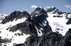
The subject of this page is the highest point along Phelps Ridge, the ridge that separates the Chiwawa River headwaters from the Phelps Creek headwaters. This peak is surrounded by higher peaks, but still offers fantastic views of the surrounding terrain, including the Phelps Creek and Chiwawa River drainages, the Lyman Lake basin, and numerous mountains of significance, including close-up views of
Seven Fingered Jack,
Mt. Maude, Mt. Fernow,
Bonanza Peak, Chiwawa Peak,
Fortress Mountain, Buck Mountain, the DaKobed Range, and
Glacier Peak. Phelps Ridge stands closely above a very popular cross-country route, Spider Gap, which gives backpackers a taste of mountaineering en route between the Upper Lyman Basin and Phelps Creek.
Getting There
Drive east from Stevens Pass or west from Leavenworth on US Highway 2 and turn north toward Lake Wenatchee. After the Wenatchee River bridge go right at a Y, then drive 1.1 miles on county road 22 and turn left on Chiwawa River forest road number 62. Drive 24 miles to near the end of the road and turn right on the Phelps Creek road. Drive to the end of this road to the trailhead.
Red Tape
All trails and some picnic areas and campsites in the Wenatchee National Forest require a regional pass costing $5/day or $30/year. Golden Age and Golden Access Passport holders may purchase the above pass at a 50% discount. The Golden Eagle Passport will not apply to the Regional Northwest Forest Pass. You can get them at
these ranger stations. The pass can also be purchased online from the
Washington Trails Association. A free wilderness permit is available at all trailheads. Party size is limited to 12 within Glacier Peak Wilderness.
When To Climb
Optimal climbing conditions occur during the months of July through September.
Camping
Numerous forest camps and commercial camping facilities can be found on and near the approach roads. Camping is permitted within the Glacier Peak Wilderness if the required wilderness permit is in your possession.
Mountain Conditions
Click here for road and trail information for the Lake Wenatchee Ranger District..

 13507 Hits
 79.04% Score
 10 Votes


gimpilator - Aug 8, 2011 6:03 pm - Voted 10/10
Phelps RidgeHey Bob, I need to mention a couple things that have been bugging me about this page for some years. The first is the name of the page. I think it's not a good practice to combine multiple peaks on one mountain page unless it's a matter of east and west (such as Buckner). Secondly, the summit of Point 8134 carries the unofficial name of "Phelps Ridge" since it's the highpoint on Phelps ridge. That might be a more appropriate name for the page, and certainly more of an interest grabber. Third, did you go to the summit of Red Mountain? The reason I ask is because I read somewhere in the forums that it's desired that members reach the summit before creating a new page. Now you are probably thinking, "why is Adam spouting out all this"? The reason is because I have had an interest in Red Mountain ever since I saw the east face in 2006. I've wanted to climb it since then and yesterday I made it to the top. I would really like to create a page for this peak and I have compiled tons of photos and route info but I don't want to step on your toes in the process either. What do you think? Adam
Bob Bolton - Aug 8, 2011 11:28 pm - Hasn't voted
Re: Phelps RidgeHey Adam. I have no problem with you creating a Red Mountain page, and indeed I need to change the name of Point 8134 to Phelps Ridge. I obviously ran out of energy to improve my pages many years ago, and should probably let someone else take ownership of most of them. Bob
gimpilator - Dec 31, 2011 11:29 am - Voted 10/10
Re: Phelps RidgeI just noticed that this page still displays Red Mountain as the summit. Here are the correct coordinates (48.165852, -120.888241). I hope to have the new Red Mountain page done by the end of the day. Also, here is a new photo of the Phelps Ridge summit which you might like. Happy New Year!
Bob Bolton - Dec 31, 2011 10:02 pm - Hasn't voted
Re: Phelps RidgeAha, good catch Adam. That has been corrected. Thanks! -Bob