Current forecasts are for up to 2 feet of new snow above 7000' in Charleston area. It will be soft powder, unconsolidated. Shorter climbs -- e.g North Sister from the N side, Fletcher from the back, Amargosa Overlook -- may be reasonable with snowshoes, but there could be big sloughs.
I've done Griffith with snowshoes in soft powder twice (6' snow) -- just start early.
Boundary Peak and Montgomery? or Charleston?
-

Alex Wood - Posts: 317
- Joined: Thu May 22, 2008 11:45 pm
- Thanked: 18 times in 14 posts
MoapaPk wrote:Current forecasts are for up to 2 feet of new snow above 7000' in Charleston area. It will be soft powder, unconsolidated. Shorter climbs -- e.g North Sister from the N side, Fletcher from the back, Amargosa Overlook -- may be reasonable with snowshoes, but there could be big sloughs.
I've done Griffith with snowshoes in soft powder twice (6' snow) -- just start early.
Is a traverse of the whole ridge out of the question? My original plan was to do Griffith and work our way over to Mummy in like two days. Is that not a good idea?
-

MoapaPk - Posts: 7780
- Joined: Fri May 13, 2005 7:42 pm
- Thanked: 787 times in 519 posts
If you are prepared to camp in snow at altitude, Griffith and Chaz from SLT may be reasonable.
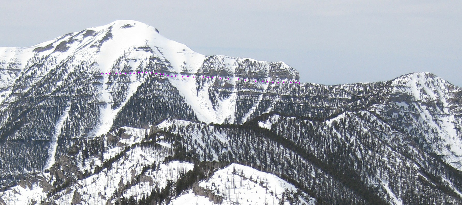
My main concern would be crossing from Chaz, via the NLT, to Mummy. The NLT goes over the route shown by pink dots here:
http://hwstock.org/mums9/chaz-NLT-danger.jpg
(View of Chaz from Mummy).
Normally, in summer, this is just a class 1 trail. However the trail skirts the top of a cliff band, with a substantial drop-off below, and the trail is rather narrow. If the snow is deep enough to cover the trail, this region can be quite treacherous.
Also either have 4wd or chains, or call ahead to find conditions from ndot or Kyle Canyon ranger station.
http://www.safetravelusa.com/nv/text.pl?file=controls
(look for sr157, sr158, and sr156)
EDIT: A fellow who went up Trail Canyon (to 9300') December 08 said that the new snow was more like 10" at that level.
http://www.safetravelusa.com/nv/
-
Alex Wood - Posts: 317
- Joined: Thu May 22, 2008 11:45 pm
- Thanked: 18 times in 14 posts
MoapaPk wrote:If you are prepared to camp in snow at altitude, Griffith and Chaz from SLT may be reasonable.
My main concern would be crossing from Chaz, via the NLT, to Mummy. The NLT goes over the route shown by pink dots here:
http://hwstock.org/mums9/chaz-NLT-danger.jpg
(View of Chaz from Mummy).
Normally, in summer, this is just a class 1 trail. However the trail skirts the top of a cliff band, with a substantial drop-off below, and the trail is rather narrow. If the snow is deep enough to cover the trail, this region can be quite treacherous.
Also either have 4wd or chains, or call ahead to find conditions from ndot or Kyle Canyon ranger station.
http://www.safetravelusa.com/nv/text.pl?file=controls
(look for sr157, sr158, and sr156)
EDIT: A fellow who went up Trail Canyon (to 9300') December 08 said that the new snow was more like 10" at that level.
http://www.safetravelusa.com/nv/
Thank you soo much for the feedback and beta! I didn't end up going to the Spring Mtns. We basically hung around the Lake Mead Area and then went out to the Mohave for a few days. A little less exciting but it worked out well with the weather. The Spring Mountains are still on the to do list though
-
MoapaPk - Posts: 7780
- Joined: Fri May 13, 2005 7:42 pm
- Thanked: 787 times in 519 posts
There a lot of colorful, usually snow-free peaks and Canyons around Lake Mead.
Some friends snowshoed up Fletcher Peak (east of Mummy) yesterday. Lots of snow, real winter up there. That route has no really long steep slopes, and is generally avalanche-safe.
Some friends snowshoed up Fletcher Peak (east of Mummy) yesterday. Lots of snow, real winter up there. That route has no really long steep slopes, and is generally avalanche-safe.
-
- Related topics
- Replies
- Views
- Last post
-
- Charleston Peak Current Conditions?
by IdahoSummits » Thu Apr 03, 2014 5:34 pm - 8 Replies
- 5880 Views
- Last post by MoapaPk

Sun Apr 20, 2014 5:24 pm
- Charleston Peak Current Conditions?
-
- Big fire near Charleston Peak, NV
by MoapaPk » Sat Jul 06, 2013 6:18 pm - 0 Replies
- 3653 Views
- Last post by MoapaPk
Sat Jul 06, 2013 6:18 pm
- Big fire near Charleston Peak, NV
-
- Charleston Peak NV Saturday 11/8
by Fletch » Thu Nov 06, 2014 6:09 am - 12 Replies
- 8811 Views
- Last post by Deb
Tue Jun 30, 2015 2:43 am
- Charleston Peak NV Saturday 11/8
-
- Boundary Peak
1, 2by gwave47 » Tue May 25, 2010 2:37 am - 16 Replies
- 7069 Views
- Last post by markv
Mon May 31, 2010 6:27 am
- Boundary Peak
-
- Boundary Peak conditions
by deungsan » Tue Nov 24, 2009 3:58 am - 8 Replies
- 3827 Views
- Last post by Clydascope
Tue Dec 01, 2009 12:56 am
- Boundary Peak conditions
Who is online
Users browsing this forum: No registered users and 0 guests