Has anybody been up this? I'm curious what it's like. I noticed on the topo the big moraine symbol over most of it - sloggy?
Thanks!
g4b
Lucy's Footpass
14 posts
Page 1 of 1
-

fatdad - Posts: 1463
- Joined: Tue Jul 24, 2007 9:39 pm
- Thanked: 101 times in 71 posts
Is that the one you access from Lake Reflection? I was up there about three years ago eyeing one of those. If it's the one I'm thinking of, there's an access trail the continues uphill on the east side of Lake Reflection into a broad talus bowl that leads to the pass. It looked way more direct than, say, Harrison Pass. Of course, I didn't get any closer than that to check it out--having decided just to hang at the lake-- so I could be totally wrong.
-

ExploreABitMore - Posts: 484
- Joined: Thu Dec 30, 2004 11:53 am
- Thanked: 15 times in 13 posts
Thanks for the info guys. Pete, I'll check out your site for the pics, thanks for the link. Sounds good though, like maybe not too tedious  Fatdad, I think that one might be Milly's Footpass. Looks like for Lucy, you might leave the trail before getting to lake reflection, but I could be totally wrong too. Anybody know?
-

Bob Burd - Forum Moderator
- Posts: 4271
- Joined: Sun Jul 22, 2001 10:42 pm
- Thanked: 572 times in 296 posts
granite4brains wrote:Thanks for the info guys. Pete, I'll check out your site for the pics, thanks for the link. Sounds good though, like maybe not too tedious
Yeah, fatdad is describing Millys. I've been up that one and it was fairly decent. I haven't been up Lucys as it looks kinda crappy from the map. Pete had two pics of it from above here:
http://www.petesthousandpeaks.com/Capti ... cysFP.html
-
ExploreABitMore - Posts: 484
- Joined: Thu Dec 30, 2004 11:53 am
- Thanked: 15 times in 13 posts
Thanks Bob! I didn't notice Pete's bottom photo the first time I looked. If Lucy's is that dirty looking chute in the middle, and the picture is not making that look steeper than it is - sure looks miserable.
I'm actually looking into this for a possible climb of Ericsson. Was thinking of going up Lucy's and down Ericsson Pass on the way back. Perhaps I'm better off going up Ericsson's Pass and Down Milly's for a nicer loop that would throw in Lake Reflection? Ah, so many options ...
I'm actually looking into this for a possible climb of Ericsson. Was thinking of going up Lucy's and down Ericsson Pass on the way back. Perhaps I'm better off going up Ericsson's Pass and Down Milly's for a nicer loop that would throw in Lake Reflection? Ah, so many options ...
-

El Cuervo - Posts: 81
- Joined: Tue Feb 28, 2006 7:09 am
- Thanked: 0 time in 0 post
I was in this area in 2008, July 20th to be exact.
I think that Millie's is a death trap, I went up it with a day pack. I would not want to go up it with anything heavier, and would want a rope to go down it. Very loose, from dirt to boulders. Skiing it would be quite good though.
Use Lucy's. Going down it is quite simple, though I went down with only a daypack.
Some images:
Looking up at the top of Millie's footpass

Looking down Millie's footpass

Looking down Millie's footpass

Looking up at Lucy's footpass

Looking down Lucy's footpass

View south into Kern watershed from top of Lucy's, note large cairn

I think that Millie's is a death trap, I went up it with a day pack. I would not want to go up it with anything heavier, and would want a rope to go down it. Very loose, from dirt to boulders. Skiing it would be quite good though.
Use Lucy's. Going down it is quite simple, though I went down with only a daypack.
Some images:
Looking up at the top of Millie's footpass
Looking down Millie's footpass
Looking down Millie's footpass
Looking up at Lucy's footpass
Looking down Lucy's footpass
View south into Kern watershed from top of Lucy's, note large cairn

-
fatdad - Posts: 1463
- Joined: Tue Jul 24, 2007 9:39 pm
- Thanked: 101 times in 71 posts
What I was orginally planning on my aborted trip was going up Harrison's and climbing both Stanford and Ericsson from there. I would up at hanging at Lake Reflection after missing the use trail branching off toward Harrison, pounding uphill through a bunch of dirt and brush and finally deciding that what I really wanted from the trip was just some down time, which the lake provided in spades.
My understanding of Harrison is that it can get icy on the north side, that there's a lot of big talus leading up that drainage, though the class 3 route up Ericsson from the pass is pretty mellow. Unlike Lucy's and Milly's, it's only class 2.
My understanding of Harrison is that it can get icy on the north side, that there's a lot of big talus leading up that drainage, though the class 3 route up Ericsson from the pass is pretty mellow. Unlike Lucy's and Milly's, it's only class 2.
-
foweyman - Posts: 579
- Joined: Mon Aug 22, 2005 12:49 pm
- Thanked: 4 times in 4 posts
You might try this route between Lucy's and Milly's from Lake Reflection over the Kings/Kern Divide. Does it have a name? It seems easier than all the others in the area in that is class 2 the whole way (like stairs up the ledges in an avy. chute) and avoids talus. It involves only a few more feet of climb.

Take the trail heading south from Lake Reflection and then turn east and go up the chute that comes out immediately left of the highpoint of the ridge. (Near the "L" in Lucy's Foot Pass on the USGS topo). From below, it is easy to get into the wrong chute so scout it out first.
From the top of the chute down to Lake Reflection:

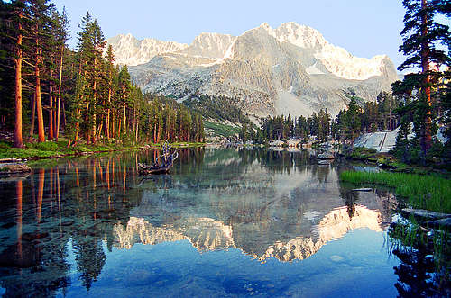
You can't beat the scenery from the camping areas at Lake Reflection either:
Take the trail heading south from Lake Reflection and then turn east and go up the chute that comes out immediately left of the highpoint of the ridge. (Near the "L" in Lucy's Foot Pass on the USGS topo). From below, it is easy to get into the wrong chute
From the top of the chute down to Lake Reflection:
You can't beat the scenery from the camping areas at Lake Reflection either:
-
Bob Burd - Forum Moderator
- Posts: 4271
- Joined: Sun Jul 22, 2001 10:42 pm
- Thanked: 572 times in 296 posts
granite4brains wrote:I'm actually looking into this for a possible climb of Ericsson. Was thinking of going up Lucy's and down Ericsson Pass on the way back. Perhaps I'm better off going up Ericsson's Pass and Down Milly's for a nicer loop that would throw in Lake Reflection? Ah, so many options ...
For what it's worth, Ericsson is easier to reach from the east side. If you haven't been to Lake Reflection or East Lake, it's well worth the trip, but after 5 or 6 times that 15mi stretch to Roads End is ... a stretch!
As for Millys, I actually missed the left-leaning ramp at the end that El Cuervo so nicely photographed. I climbed the class 3 rock to the right somewhere that I thought was quite fun. Later I was told that's called the "Storkman variation", presumeably after Warren Storkman?
-
ExploreABitMore - Posts: 484
- Joined: Thu Dec 30, 2004 11:53 am
- Thanked: 15 times in 13 posts
Thanks again all - lots of great pics and info, which helps a lot. Looks like all the routes are decent enough. Being a spur of the moment kind of guy, I'll probably just randomly pick one that day
-
fatdad - Posts: 1463
- Joined: Tue Jul 24, 2007 9:39 pm
- Thanked: 101 times in 71 posts
foweyman,
Again, nice shot. Totally different color scale than my profile picture, which is also Lake Reflection.
Ericsson may be easier to get to from the E. side, but not by much. My last trip into the Sierra was over Shepherd's Pass with the intent of possibly trying Ericsson and Stanford (my earlier trip having been a bust). Even after you're done humping up Shepherd's Pass, Lake South American, et al, still feels really far away.
-
Bob Burd - Forum Moderator
- Posts: 4271
- Joined: Sun Jul 22, 2001 10:42 pm
- Thanked: 572 times in 296 posts
fatdad wrote:Ericsson may be easier to get to from the E. side, but not by much. My last trip into the Sierra was over Shepherd's Pass with the intent of possibly trying Ericsson and Stanford (my earlier trip having been a bust). Even after you're done humping up Shepherd's Pass, Lake South American, et al, still feels really far away.
The route over Shepherd Pass is about the same distance as from Roads End, 17-18mi. The short way is from Onion Valley via University Pass and Andys Foot Pass, about 8mi. Non-trivial amount of gain, though. And of course University Pass sucks without snow...
14 posts
Page 1 of 1
Who is online
Users browsing this forum: No registered users and 0 guests