Lundy Canyon Ice
10 posts
Page 1 of 1
-

JHH60 - Posts: 1244
- Joined: Tue Oct 21, 2008 6:59 pm
- Thanked: 111 times in 91 posts
Lundy Canyon Ice
How early does Lundy canyon ice typically come into shape? Is it worth checking out mid-November?
-

bearbnz - Posts: 348
- Joined: Sun Aug 04, 2002 5:37 pm
- Thanked: 12 times in 5 posts
Driving down from Saddlebag on Sunday (11/1) I stopped and looked over the edge, and there is very little ice on the walls. It's been cold enough, but there doesn't seem to be an abundance of available water flowing through there.
-

WML - Posts: 246
- Joined: Wed May 06, 2009 12:20 am
- Thanked: 19 times in 15 posts
bearbnz wrote:Driving down from Saddlebag on Sunday (11/1) I stopped and looked over the edge, and there is very little ice on the walls. It's been cold enough, but there doesn't seem to be an abundance of available water flowing through there.
Does it look climbable or too thin for that? Also, what were you up to ~Saddlebag? What's the word on road conditions? Get a chance to look at any of the couloirs on North Peak?
-

rhyang - Posts: 8960
- Joined: Wed Apr 28, 2004 8:55 pm
- Thanked: 59 times in 38 posts
Last post on this thread implies that there might be ice in one of the NP couloirs. We didn't bother to look when we were up there a couple weekends ago after seeing Dana Couloir snowed over. I would imagine the approach / descent could be posthole-icious 
Saddlebag Lake Road doesn't get closed in the fall until 120 closes, but they also don't plow it .. you will probably want 4wd if you go up there .. a lot of the road seemed to melt out quickly, but near the dam there were deep drifts in the shade.
I wouldn't bother going to LVC until mid-December at the earliest. Hopefully by then there will be enough snow to make the approach talus at least tolerable.
Miguel Forjan's pics from Lundy last December -
http://picasaweb.google.com/smithdljr/LundyFalls#
-
bearbnz - Posts: 348
- Joined: Sun Aug 04, 2002 5:37 pm
- Thanked: 12 times in 5 posts
WML wrote:bearbnz wrote:Driving down from Saddlebag on Sunday (11/1) I stopped and looked over the edge, and there is very little ice on the walls. It's been cold enough, but there doesn't seem to be an abundance of available water flowing through there.
Does it look climbable or too thin for that? Also, what were you up to ~Saddlebag? What's the word on road conditions? Get a chance to look at any of the couloirs on North Peak?
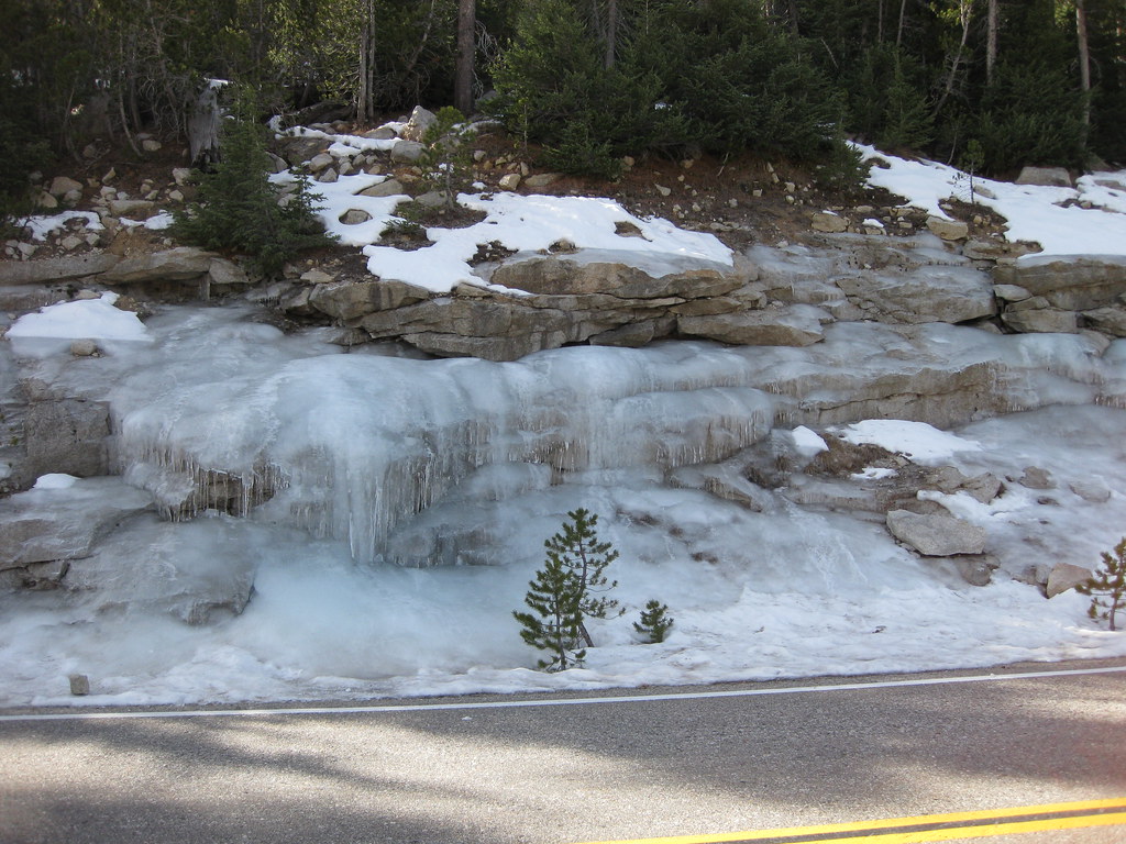
Not climbable, still doesn't extend to the ground, what's there is thin. Saddlebag road is good all the way to the lake, no 4wd required, the road is clear and almost all dry. I did not walk up to the couloirs, but I may this coming weekend.
-

The Chief - Thanked: time in post
LVC will not be in and safe till at least the middle to the end of next month. That is the prevailing historical scenario.
I promise that I will post updates when the Walls are good to go.
Safety is paramount. It is the key to continued Access with the Edison & DWP folks. Trust me.....
Be patient, please.
I promise that I will post updates when the Walls are good to go.
Safety is paramount. It is the key to continued Access with the Edison & DWP folks. Trust me.....
Be patient, please.
-
WML - Posts: 246
- Joined: Wed May 06, 2009 12:20 am
- Thanked: 19 times in 15 posts
The Chief wrote:LVC will not be in and safe till at least the middle to the end of next month. That is the prevailing historical scenario.
I promise that I will post updates when the Walls are good to go.
Safety is paramount. It is the key to continued Access with the Edison & DWP folks. Trust me.....
Be patient, please.
Awesome thanks man, any word on what the snow is like on the approach to North Peak's couloirs is like? Any word as to how good of shape they're in?
Appreciate the help, Chief.
-
rhyang - Posts: 8960
- Joined: Wed Apr 28, 2004 8:55 pm
- Thanked: 59 times in 38 posts
Decided to head up to Tuolumne one more time this past weekend. Saw some ice flows across from Pothole Dome -
Dana Couloir still looked snowy from Saddlebag Lake Road.
The road was pretty much clear up to the lot above the marina. I decided to go for a stroll.
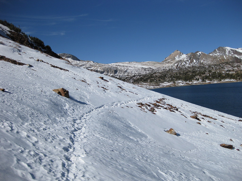
The snow was hard, even in late morning. There were some older ski tracks, and newer crampon tracks. I hadn't brought an axe or crampons, just a trekking pole.
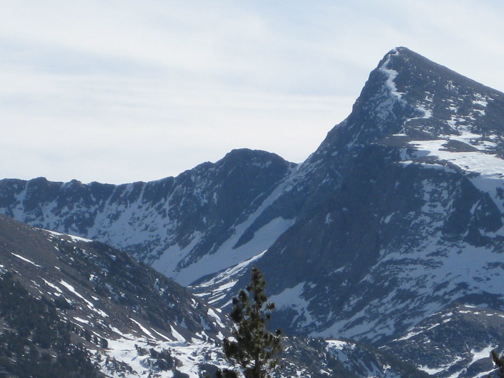
Mt. Conness
North Peak

Looked as though you could crampon all the way up to the glacier, and as I got closer it looked like people had been doing just that. I took the usual class 2-3 ledges though. I got to about 11000-ish feet, took some pics of the couloirs and turned around.
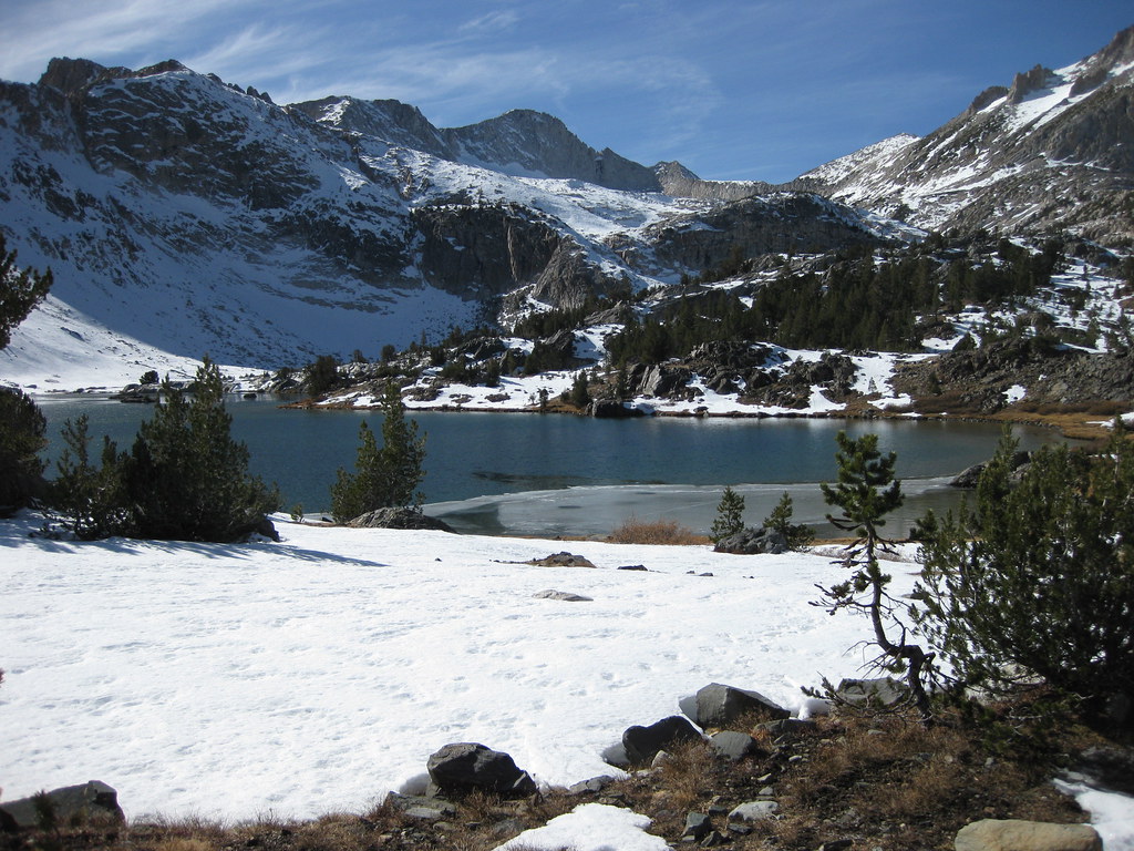
Right and middle couloirs
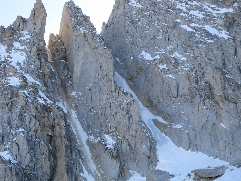
Left couloir
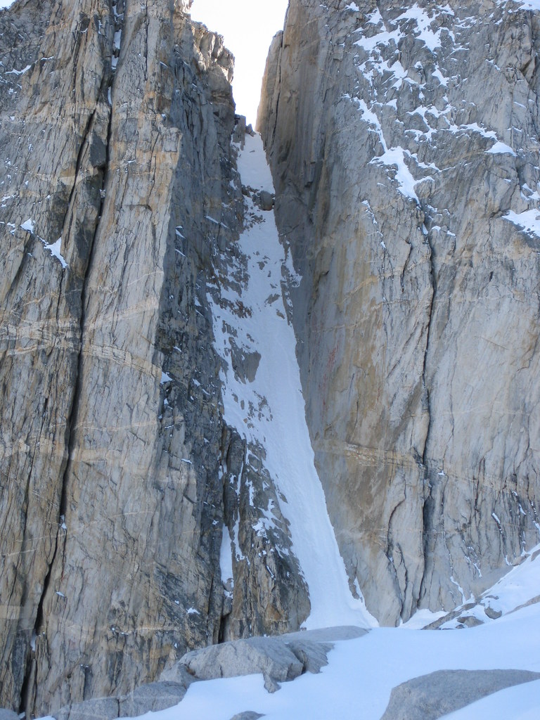
Chilly day, but beautiful with all the snow. Full set here.
Sounds like the next storm is set to move in over Veteran's Day ..
Dana Couloir still looked snowy from Saddlebag Lake Road.
The road was pretty much clear up to the lot above the marina. I decided to go for a stroll.
The snow was hard, even in late morning. There were some older ski tracks, and newer crampon tracks. I hadn't brought an axe or crampons, just a trekking pole.
Mt. Conness
North Peak
Looked as though you could crampon all the way up to the glacier, and as I got closer it looked like people had been doing just that. I took the usual class 2-3 ledges though. I got to about 11000-ish feet, took some pics of the couloirs and turned around.
Right and middle couloirs
Left couloir
Chilly day, but beautiful with all the snow. Full set here.
Sounds like the next storm is set to move in over Veteran's Day ..
10 posts
Page 1 of 1
-
- Related topics
- Replies
- Views
- Last post
-
- Virginia Lakes/Lundy Canyon areas
by Bill562 » Sat May 21, 2016 8:36 pm - 2 Replies
- 1371 Views
- Last post by 96avs01

Sun May 22, 2016 9:51 pm
- Virginia Lakes/Lundy Canyon areas
-
- Eagle Creek Canyon ice conditions?
by Diggler » Tue Feb 23, 2010 12:01 am - 0 Replies
- 1604 Views
- Last post by Diggler
Tue Feb 23, 2010 12:01 am
- Eagle Creek Canyon ice conditions?
-
- Mecca Hills Painted Canyon/Ladder Canyon
by Deb » Wed Jan 26, 2011 12:28 am - 4 Replies
- 3830 Views
- Last post by KathyW
Mon Feb 07, 2011 2:08 pm
- Mecca Hills Painted Canyon/Ladder Canyon
-
- lyell canyon
1, 2by jareds » Thu Sep 02, 2010 11:19 pm - 29 Replies
- 5310 Views
- Last post by jareds
Wed Sep 08, 2010 12:15 am
- lyell canyon
-
- Tenaya Canyon
by Misha » Mon Jun 11, 2012 2:24 am - 5 Replies
- 3604 Views
- Last post by Rob
Wed Aug 08, 2012 10:55 pm
- Tenaya Canyon
Who is online
Users browsing this forum: Google [Bot] and 0 guests