MooseTracks wrote:rajeshkh wrote:Hi Laura,
Thanks a lot for the detailed reply. We are entering via Piute Pass on June 29th and exiting via Bishop Pass on July 5th, at least that is the plan for now. Looks like the weather is warming up nicely and we are really hoping for some serious melt. I am wondering if there is a way to avoid using crampons an dice axe, by avoiding the passes. Anyway we can get to EVO without going through the pass?
Your pictures and trip reports are amazing, truly the best back yard
Thanks
Rajesh
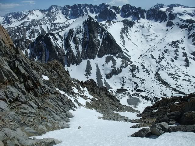
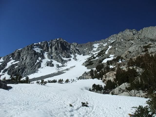
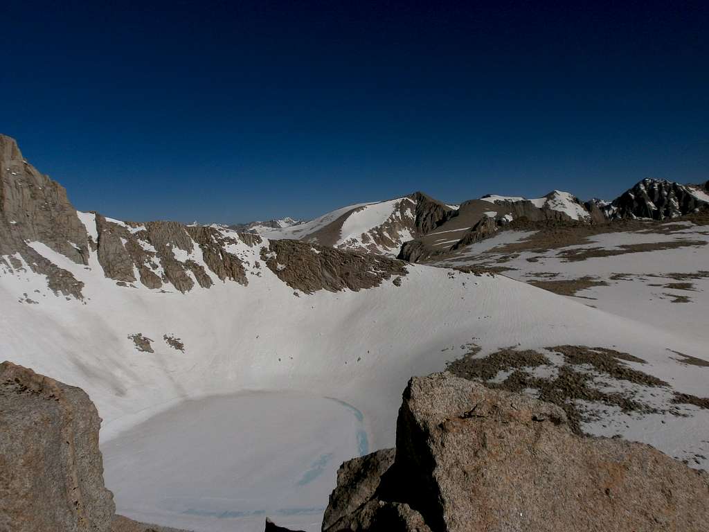
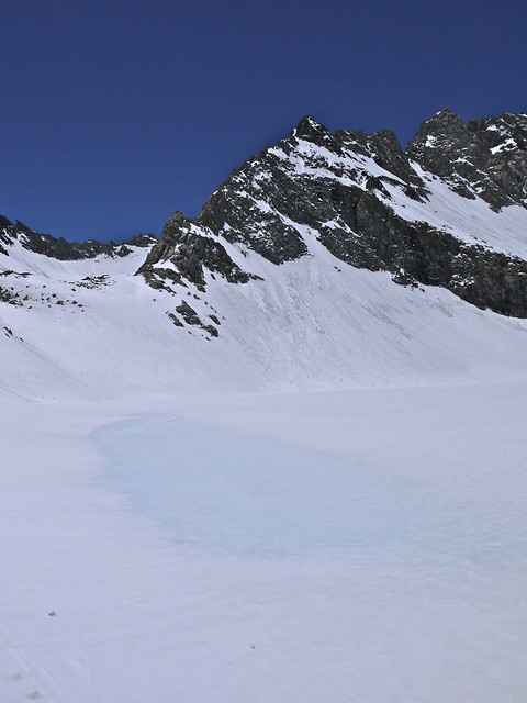
I'm not sure what you mean by "without going over the Pass". By starting at North Lake, you probably won't have to deal with gear, since Piute Pass is perhaps one of the lowest angle passes I've gone over in the Sierra. It's 5 miles from the trailhead at North Lake (6 or so from the parking area/pack station), and it gains a shade over 2000 vertical feet, the largest gain (in steepness) coming just before Loch Leven. From there it's an easy drop through Humphreys Basin to Hutchinson Meadow. Now: I haven't hiked the drop from there to the JMT along Piute Creek, so someone else should give the lowdown on that, but I'm assuming that it will be mostly melted out trail by the time you get there, especially if the weather continues as it is (read: warming trend, massive meltoff, flooding home in Bishop, yada yada yada). The climb up to EVO Basin from the canyon might also be interesting, and I couldn't tell the exact snow level when I was there (mainly because it was, well, snowing). There are a few traverses on the south side of Muir Pass where axe/crampons/knowledge of how to use them would increase safety, although the runouts are pretty benign. As you can see from the photos of both 2009 and 2011, there is a good deal of snow for a good long way on either side of the pass around your time frame.
The climb up from LeConte Canyon to Dusy Basin could also be quite challenging with the snow, especially if you hit it in afternoon. An exercise in postholing is always a great way to burn a few more calories.![]()
Bottom line, at least for me, is that crampons/ice axe/knowledge of how to use them would be included in your gear for the trip. Hell, with the pack going through a rapid melt, snowshoes might be warranted to avoid above-mentioned postholing (although I posthole with them on, too... hurm...).
Glad you like the pics/reports! And happy to help.![]()
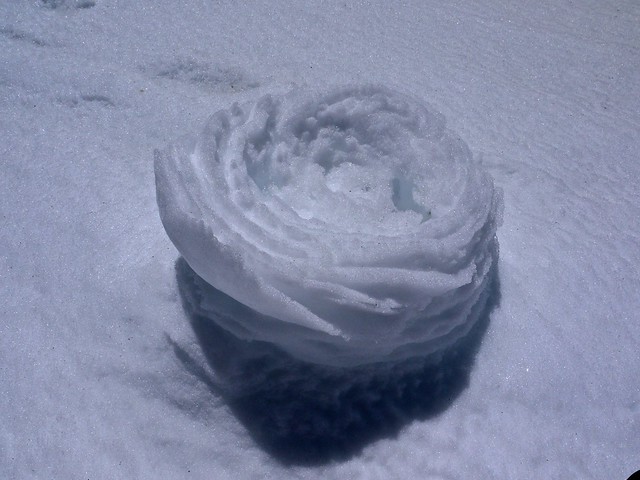
Oh, and BIADH:
A roller just above Echo Lake. There wasn't an avy there, but almost every north-facing chute below the Clyde Spires had let something go (mostly slough):
Believe me, I had my head screwed on tight for this trip. It was amazing how mentally tired I was, as much as physical, from constantly being on the alert for shifts in conditions.
fossana wrote:+ photos
Loch Leven from Emerson
Emerson from Loch Leven
MooseTracks wrote:Rajesh, not to nit-pick, but you do realize that Lamarck Col is almost 1000ft higher than Bishop Pass, and can be notoriously tricky to get down? It's mostly a boulder scramble to come up from Darwin Lakes, if the snow finished melting out, and there was good ice between a lot of the exposed rocks. I only mention it because of your mentioning a desire to not take any snow gear.
MooseTracks wrote:Honestly, be open to changing plans. With the snow pack changing so rapidly, being aware of the surroundings at all times will be critical. You might end up choosing a lower route/trip, or change the dates of your trip, that would be more suited to avoiding the snow. The added complication of needing to meet up with another person makes things all the more difficult.
For example, entering over Piute Pass and heading to Hutchinson Meadow to spend the first night. I haven't done the descent from there to the JMT, but have heard the creek crossings can be quite challenging. So instead, why not turn north and into French Canyon, which is probably below snow line (10K) until it climbs up to Pine Creek Pass (11K+). From there, you can wander into the Royce Lakes Basin or the French Lakes region, all of which have more gentle terrain. If you head into the Royce Lakes basin, you can connect into Granite Park and head towards Italy Pass, again, mostly gentle terrain but higher, so you'll probably have snow/suncups with which to deal. From the French Lakes area, you can come back to Humphreys Basin over, I think, Purple Pass (??), which is east of Pilot Knob.
I think I've seen one of the prettiest sunsets/sunrises while camped at Royce Col.
If you do head down to the JMT, you could stay low by heading south into the Goddard Creek drainage as well.
Creeks/crossings are also going to be a major issue. I've seen some holes w/ snow about 4' deep around the edges, which gives a sometimes false sense of security when crossing on bridges.
Only other thing I can think of is shifting your trip to August if you truly want to avoid snow.
The Chief wrote:At this rate, sounds like you are going to stay home.
What ever happened to just getting out there and enjoying the challenge of it all?
PS: It really isn't all as bad as it sounds. I have been up and out there every other day for the past month and can say that it is melting out fast in most locations.
Here is a pic looking northwest from the East Ridge of Russell taken the morning before last....
MooseTracks wrote:Honestly, be open to changing plans. With the snow pack changing so rapidly, being aware of the surroundings at all times will be critical. You might end up choosing a lower route/trip, or change the dates of your trip, that would be more suited to avoiding the snow. The added complication of needing to meet up with another person makes things all the more difficult.
For example, entering over Piute Pass and heading to Hutchinson Meadow to spend the first night. I haven't done the descent from there to the JMT, but have heard the creek crossings can be quite challenging. So instead, why not turn north and into French Canyon, which is probably below snow line (10K) until it climbs up to Pine Creek Pass (11K+). From there, you can wander into the Royce Lakes Basin or the French Lakes region, all of which have more gentle terrain. If you head into the Royce Lakes basin, you can connect into Granite Park and head towards Italy Pass, again, mostly gentle terrain but higher, so you'll probably have snow/suncups with which to deal. From the French Lakes area, you can come back to Humphreys Basin over, I think, Purple Pass (??), which is east of Pilot Knob.
I think I've seen one of the prettiest sunsets/sunrises while camped at Royce Col.
If you do head down to the JMT, you could stay low by heading south into the Goddard Creek drainage as well.
Creeks/crossings are also going to be a major issue. I've seen some holes w/ snow about 4' deep around the edges, which gives a sometimes false sense of security when crossing on bridges.
Only other thing I can think of is shifting your trip to August if you truly want to avoid snow.
[/quote]Users browsing this forum: No registered users and 0 guests