Perhaps Nat'l Geo TOPO has changed, but here's what I remember from the old days, perhaps 3 years ago (I gave away my copy):
If you downloaded a track from GPS to computer, no matter how long, it was turned into separate waypoints.
If you drew a track on the computer, and uploaded it to the GPS, it was turned into waypoints-- a confusing mass of waypoints on the GPS screen.
Okay, I have given up on Nat'l Geographic's TOPO! software
-

Luciano136 - Posts: 3778
- Joined: Thu Jan 19, 2006 11:46 pm
- Thanked: 11 times in 10 posts
MoapaPk wrote:Perhaps Nat'l Geo TOPO has changed, but here's what I remember from the old days, perhaps 3 years ago (I gave away my copy):
If you downloaded a track from GPS to computer, no matter how long, it was turned into separate waypoints.
If you drew a track on the computer, and uploaded it to the GPS, it was turned into waypoints-- a confusing mass of waypoints on the GPS screen.
Yes, both routes and tracks are made up of waypoints but they can be downloaded and uploaded as one unit (i.e. track or route).
I usually draw a route, have the program create a GPS route with 10-20 waypoints and upload the whole route to the GPS. Then you can chose to navigate the route or just to a separate waypoint. I quite like it.
-

nhluhr - Posts: 182
- Joined: Mon Jun 15, 2009 3:44 pm
- Thanked: 1 time in 1 post
You are missing a big point on quality. Since you're limited to whatever your printer can handle (8.5x11), you either have to zoom out and have illegible map features or lost detail OR forgo all the context of the map that would be helpful for, you know, actual navigation.... Having a zoomed in snippet of a map is useless if you need to triangulate from distant landmarks. Also, the prints that TOPO produce are NEVER as clear to read as a professionally printed USGS quad. Even if you go to REI and get it printed from the TOPO! kiosk, it still sucks.Buz Groshong wrote:nhluhr wrote:I don't know why anybody would use TOPO! unless they REALLY need the ability to center the area of interest on a print-out. But then you're limited by crappy print quality, smaller sheet size, badly aliased graphics, and you're still paying for each map you download!
USGS quads are the way to go. If you can't find what you want locally, order it directly from the USGS! http://store.usgs.gov You can even preview the full resolution pdf version of it first.
Reasons:
1. I can print on letter-size paper at home very cheaply (once I've bought the CD) - perfect for a typical day hike. I can also draw the route on it before I print it out and can annotate it however I please.
2. I can run a profile of the hike route.
3. I can upload data from my GPS and save it with the map file (or save it separately).
4. I can download waypoints from the map to my GPS.
5. The quality is only crappy when the corresponding USGS quad is crappy.
TOPO! still requires credits to purchase more quads/segments so it's not like it's still free. Once you use up the credits that come with your software (not a whole lot), you have to start paying again. If you just really want to print maps on 8.5x11, you can download every USGS quad for free from the USGS and print the PDF on whatever you want with far more control over output fonts, line thickness, etc thanks to the PDF format.
Regarding maps on your GPS, assuming you're using Garmin like 90% of the world, you can download free open source topo maps that are the same contour/scale/detail as USGS quads and you can also download transparent overlays for trails, landmarks, etc.
Seriously, who pays for all this? It's FREE already! The only thing worth paying for is high quality prints of the maps... and that's what store.usgs.gov is for.
-

MoapaPk - Posts: 7780
- Joined: Fri May 13, 2005 7:42 pm
- Thanked: 787 times in 519 posts
nhluhr wrote:Regarding maps on your GPS, assuming you're using Garmin like 90% of the world, you can download free open source topo maps that are the same contour/scale/detail as USGS quads and you can also download transparent overlays for trails, landmarks, etc.
The display programs for the Garmin maps (e.g. MapSource) suck at output, and the vectorized contours are a lot cruded in detail than what was shown by the OP, even when you get the 24k maps.
Seriously, who pays for all this? It's FREE already! The only thing worth paying for is high quality prints of the maps... and that's what store.usgs.gov is for.
I've used a lot of the "free" programs, and none compare in terms of flexibility, rapidity of response, and handling of GPS data with the purchased programs. After I have uploaded the tracks and waypoints to the GPS, I print out several maps at different zooms of the areas of interest, with the tracks and waypoints on them. I greatly prefer that system to having a large map flapping in the wind and being unfolded at every stop. After the trip, I just recycle the maps.
-

Bill Reed - Posts: 534
- Joined: Thu Apr 21, 2005 4:46 pm
- Thanked: 78 times in 59 posts
Here's a bizarre example of Topo's quality and reliability. The location of the road is pre-1980. Even more ridiculous is the golf course located at 10,080 ft, above the reservoir. Anybody out there ever played this course?:lol:
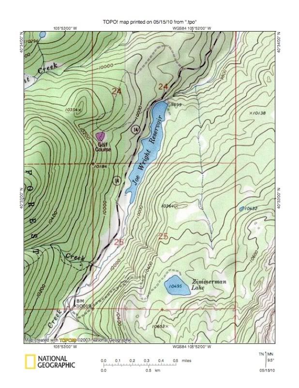
Top view of the upper Poudre Canyon NNE of Cameron Pass.
Top view of the upper Poudre Canyon NNE of Cameron Pass.
-

QITNL - Posts: 150
- Joined: Mon Dec 10, 2007 11:22 am
- Thanked: 57 times in 25 posts
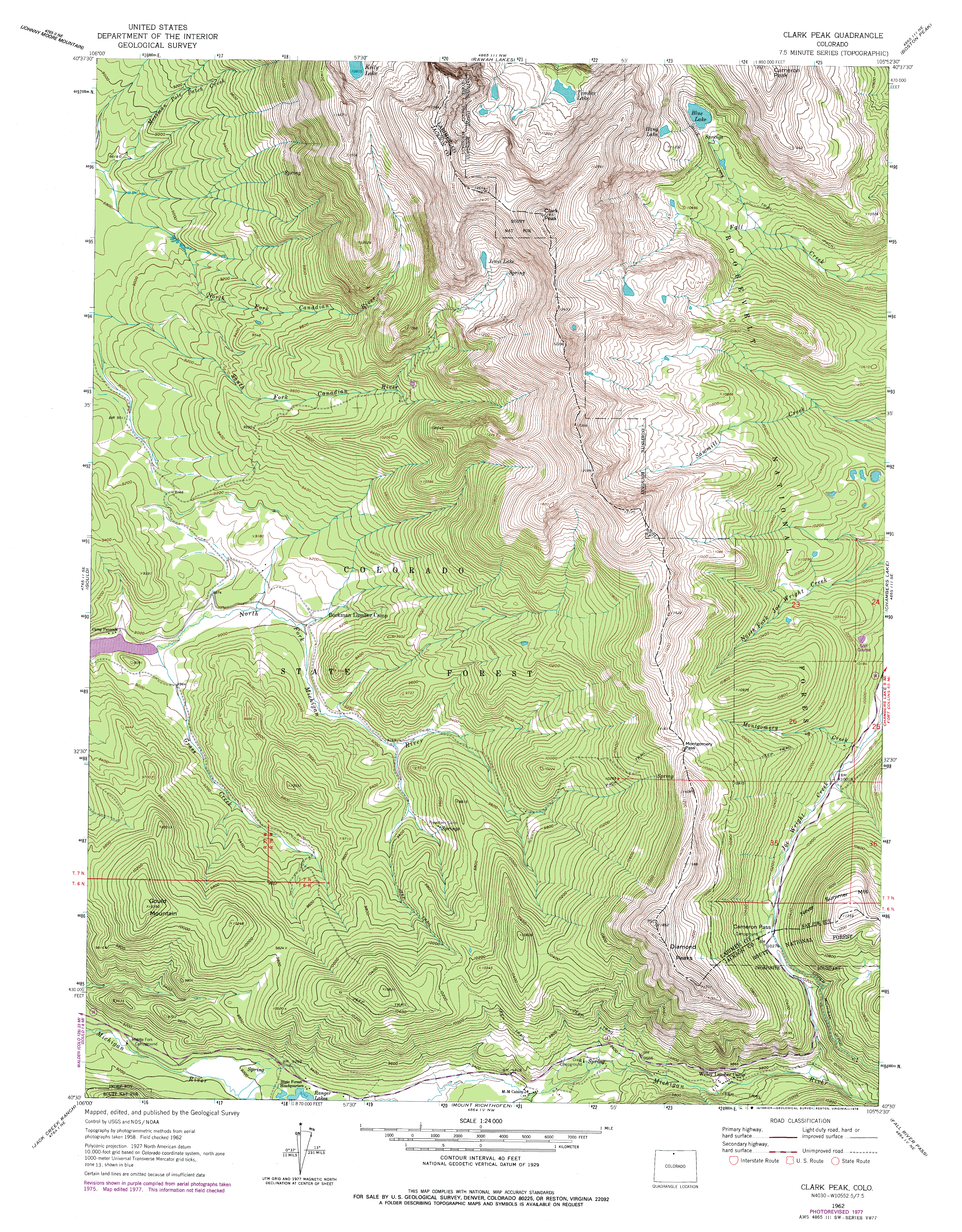
Download this:
http://www.landscapeimagery.com/ClarkPeak.png
and you'll find that the Golf Course is mapped on the original USGS topo.
The maps look a lot better if you turn off that damn shading.
But we are not here to praise TOPO but to bury it, I gather.
http://www.landscapeimagery.com/ClarkPeak.png
and you'll find that the Golf Course is mapped on the original USGS topo.
The maps look a lot better if you turn off that damn shading.
But we are not here to praise TOPO but to bury it, I gather.
-
Bill Reed - Posts: 534
- Joined: Thu Apr 21, 2005 4:46 pm
- Thanked: 78 times in 59 posts
Well, I'll tell ya. I see the golf course on your link, but I have the original topo, and there ain't no golf course on it. But even if there was, there ain't no golf course there, and the notion that there is one, is beyond absurd.
If Topo was trying to show anything close to current reality on their maps, golf courses at 10,080 in the Roosevelt NF would not appear on them.
If Topo was trying to show anything close to current reality on their maps, golf courses at 10,080 in the Roosevelt NF would not appear on them.
-

rockymtnclimber - Posts: 63
- Joined: Mon Mar 05, 2007 12:48 am
- Thanked: 1 time in 1 post
What is this about using credits to print off of TOPO!, and then having to pay once your credits run out? Is this a version of TOPO! that I've never seen? I've got 7 different states, have printed dozens, if not 100+ maps, and never seen anything about using credits to print or having to pay. I personally am pretty happy with the TOPO! software, but more, I'm just curious now about this talk of paying to print.
-
geocar - Posts: 1
- Joined: Fri Oct 07, 2011 11:22 pm
- Thanked: 0 time in 0 post
Re: Okay, I have given up on Nat'l Geographic's TOPO! softwa
I hope people are still using this blog ... I am about to give up too. The TOPO software has a number of drawbacks which up til now I have been able to work around (roads that are 50 years gone, etc.). But now something different is happening -- when I open a map using "Return to map of Previous Session", TOPO takes me to a blank screen! After some looking around, I see that instead of taking me back to my previous map (which was in central Utah -- 12S), TOPO took me to another zone, which seems to be in Mexico (12R), where there is no map coverage. Of course I don't want to be here, and I can get my original map back by pulling up the waypoints and clicking on one. But this is a bother and unnecessary; the software should not do this.
I have written to TOPO and only gotten nonsensical answers, like "You cannot show maps in an area where there is no map coverage" -- DUH. I certainly did not open my map in this zone on purpose. Another time they told me how to create a note, which had nothing to do with my description of the problem. They don't seem able to answer the question or even to reply in any useful way. I know they are no longer supporting this software, and haven't for a while, so I am wondering if any readers of this blog have had this problem, and what you did about it.
On a Mac, OS 10. The blank window that comes up is gray, so TOPO is there, just not where it should be.


-

kylenicolls - Posts: 151
- Joined: Sun Jul 03, 2011 6:15 am
- Thanked: 8 times in 6 posts
Re: Okay, I have given up on Nat'l Geographic's TOPO! softwa
Used used it on Mac as well. Once I updated it, I was a lot happier. I did quickly dismiss the idea of printing 8.5x11 maps. I will just spend 10 bucks on a high quality topo from a store near the mountain or USGS.
-

kayakerSS - Posts: 25
- Joined: Tue Mar 03, 2009 4:56 pm
- Thanked: 0 time in 0 post
Re: Okay, I have given up on Nat'l Geographic's TOPO! softwa
It's all about ArcGIS! I can do pretty much any (map related) thing I want, and I've always found Esri's basemaps to be reliable.
-
MoapaPk - Posts: 7780
- Joined: Fri May 13, 2005 7:42 pm
- Thanked: 787 times in 519 posts
Re: Okay, I have given up on Nat'l Geographic's TOPO! softwa
TOPO! seemed in the dark ages for handling of tracks; the printing used to be obscure. Maybe it has improved since I gave away my copy 2 years ago.
-
- Related topics
- Replies
- Views
- Last post
-
- Nat'l Geographic article on Yosemite climbing
by Alpinist » Fri Apr 22, 2011 6:25 pm - 4 Replies
- 3056 Views
- Last post by Hotoven

Wed Apr 27, 2011 5:46 pm
- Nat'l Geographic article on Yosemite climbing
-
- Topo Software
1, 2by peninsula » Fri Jun 24, 2011 12:27 am - 17 Replies
- 7709 Views
- Last post by Luc
Tue Jul 12, 2011 1:53 am
- Topo Software
-
- Software to make a topo
by sjarelkwint » Tue Oct 23, 2012 12:37 pm - 0 Replies
- 586 Views
- Last post by sjarelkwint
Tue Oct 23, 2012 12:37 pm
- Software to make a topo
-
- TOPO! software and Windows 8
by Noondueler » Wed Mar 20, 2013 11:29 pm - 12 Replies
- 8272 Views
- Last post by jgaffney
Tue Jul 09, 2013 12:51 am
- TOPO! software and Windows 8
-
- Betaflash (free topo creation software)
by fossana » Fri Jan 15, 2010 4:45 pm - 10 Replies
- 4797 Views
- Last post by arineod
Mon Apr 24, 2023 1:03 am
- Betaflash (free topo creation software)
Who is online
Users browsing this forum: No registered users and 0 guests