Hey folks,
I'd like to go with a friend up Three Fingered Jack this coming weekend (June 8-10) but I know little about it. I've read the mountain page on SP and some random resources through a Google search, but that's it.
Where is the trailhead in terms of distance from the summit? Anyone know if parking/camping is accessible near the trailhead now? Also, what gear would you recommend for this time of year?
Any help is appreciated!
Cheers,
Anthony
Three Fingered Jack
6 posts
Page 1 of 1
-

billisfree - Posts: 373
- Joined: Sat Dec 22, 2007 8:39 am
- Thanked: 16 times in 14 posts
Re: Three Fingered Jack
I took a "hike" from the Hoodoo TH a few years back. June 30th 2009 to be exact.
First, don't get confused over the location of the trail head. When you round Hogg Rock... watch for the turnoff to the Hoodoo Ski Resort on south side. The next turn off, 350 ft east of this turnoff leads to a winter play area with restrooms where you might want to make a pit stop.
The turnoff to the 3FJ trailhead is precisely 1,800ft east the turnoff to Hoodoo Ski Resort road (NF-2690).
Hogg rock is an interesting feature... see
http://en.wikipedia.org/wiki/Hogg_Rock
Lesson #1 - the mosquitos are EVERYWHERE! Fresh melting snow means LOTS of them! I recall the extreme frustration just trying to get my pack ready, while dozens of mosquitos were attacking me in the parking lot. I ended up sitting in my confined car - trying to get my pack ready. Even then several moquitos followed me inside and had to be be dealt with!

Once on the trail - I had to STAY moving or the mosquitos would move in fast.
Lesson #2 - I went in on June 30th. Half the trail was still under snow. So the trail was lost soon enough. Wear good waterproof boots and blaze your own path toward 3FJ.
Lesson #3 - Being offtrail, I went high on the ridge leading to 3FJ. A better approach would be to stay low and arrive at base of the mountain - THEN climb upwards.

From where I stood on the ridge near 3FJ, it didn't seem inviting to bush-wack down and re-climb.

BUT... with the trail under snow there wasn't any good options.
Conclusion - do the hike in late July.
First, don't get confused over the location of the trail head. When you round Hogg Rock... watch for the turnoff to the Hoodoo Ski Resort on south side. The next turn off, 350 ft east of this turnoff leads to a winter play area with restrooms where you might want to make a pit stop.
The turnoff to the 3FJ trailhead is precisely 1,800ft east the turnoff to Hoodoo Ski Resort road (NF-2690).
Hogg rock is an interesting feature... see
http://en.wikipedia.org/wiki/Hogg_Rock
Lesson #1 - the mosquitos are EVERYWHERE! Fresh melting snow means LOTS of them! I recall the extreme frustration just trying to get my pack ready, while dozens of mosquitos were attacking me in the parking lot. I ended up sitting in my confined car - trying to get my pack ready. Even then several moquitos followed me inside and had to be be dealt with!
Once on the trail - I had to STAY moving or the mosquitos would move in fast.
Lesson #2 - I went in on June 30th. Half the trail was still under snow. So the trail was lost soon enough. Wear good waterproof boots and blaze your own path toward 3FJ.
Lesson #3 - Being offtrail, I went high on the ridge leading to 3FJ. A better approach would be to stay low and arrive at base of the mountain - THEN climb upwards.
From where I stood on the ridge near 3FJ, it didn't seem inviting to bush-wack down and re-climb.
BUT... with the trail under snow there wasn't any good options.
Conclusion - do the hike in late July.
Last edited by billisfree on Mon Jun 04, 2012 3:10 pm, edited 2 times in total.
-

Brian C - Posts: 93
- Joined: Sun Nov 15, 2009 9:19 pm
- Thanked: 20 times in 18 posts
Re: Three Fingered Jack
I would guess the route would still be patchy snow this time of year (i haven't done 3FJ). Let me know if it's in shape because I'll be on the area soon and would like to do it too.
B
B
-

nicozone - Posts: 33
- Joined: Mon Jun 08, 2009 8:12 pm
- Thanked: 1 time in 1 post
Re: Three Fingered Jack
I've been eyeing it this year, but haven't found a good weekend to try it. A few friends went up in early May, and put a TR on Cascade Climbers:
http://cascadeclimbers.com/forum/ubbthreads.php?ubb=showflat&Number=1067699
The conditions should be something in-between billisfree's beta and this TR.
http://cascadeclimbers.com/forum/ubbthreads.php?ubb=showflat&Number=1067699
The conditions should be something in-between billisfree's beta and this TR.
-

ascasson - Posts: 48
- Joined: Thu Mar 08, 2012 6:54 pm
- Thanked: 2 times in 2 posts
Re: Three Fingered Jack
What's required to get to the top? It looks like some vertical rock. Is it simple climbing to a certain point?
-

jessbee - Posts: 10
- Joined: Fri Dec 30, 2005 9:11 am
- Thanked: 0 time in 0 post
Re: Three Fingered Jack
ascasson wrote:What's required to get to the top? It looks like some vertical rock. Is it simple climbing to a certain point?
Did you end up doing this climb?
There's still a ton of snow up there. Here's a view of TFJ from Duffy Lake taken today. The climbers' route comes up the right side of the photo.
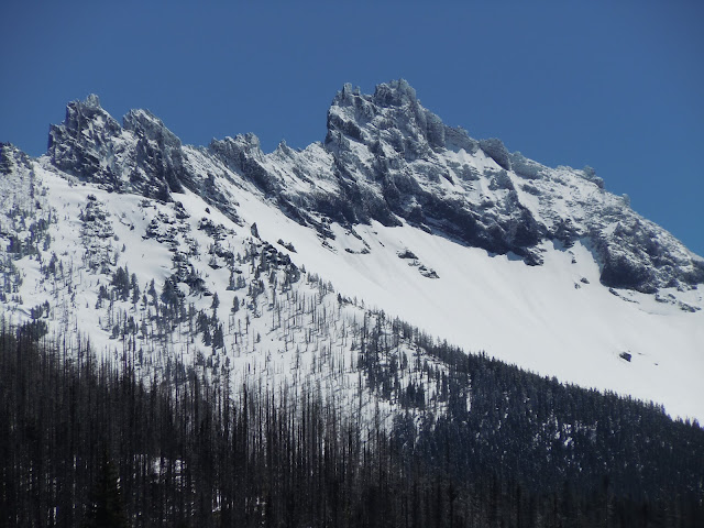
Most folks climb it in late July--September when it's snow-free, unless you'd rather hit it when some snow is holding the rock together.
From what I remember it's about 10 miles round trip, with a couple of sections with lots of exposure and loose rock that you might want a fixed line or a belay. The top "vertical rock" pitch is really knobby and easy to climb (5.2?), with not many opportunities for protection. Probably quicker and safer to free solo and use the rope for the rap down. It all depends on your comfort level, of course.
Good advice from billisfree, we also made a beeline for the ridge too early, had to downclimb and re-climb. There is a gigantic cairn at the climber's trail so be patient and start the climb from there.
6 posts
Page 1 of 1
-
- Related topics
- Replies
- Views
- Last post
-
- Three Fingered Jack
by kylenicolls » Tue Dec 04, 2012 8:59 pm - 2 Replies
- 1778 Views
- Last post by kylenicolls

Thu Dec 06, 2012 4:07 am
- Three Fingered Jack
-
- beta for Mt. Jefferson and Three-Fingered Jack?
by MacKenzie » Sun Aug 22, 2010 6:11 pm - 8 Replies
- 4899 Views
- Last post by Snowslogger
Sun Aug 29, 2010 6:58 pm
- beta for Mt. Jefferson and Three-Fingered Jack?
Who is online
Users browsing this forum: No registered users and 0 guests