For anyone with climbing plans in the CO Front Range, I thought it might be a good idea to let folks know how the recent flooding has affected access. So, to the best of my knowledge, and as of right now (9/16) here it goes:
-Boulder Canyon is totally inaccessible. Highway 119 (Canyon Blvd) has been obliterated by a massive landslide in the canyon, and will likely remain closed for quite some time.
-Eldorado Canyon access is problematic due to a washed-out bridge along Eldorado Springs Drive. You might be able to get there by hiking along the Mesa Trail, but major erosion has probably taken place there too, so better give it some time.
-All of Rocky Mountain National Park, including Lumpy Ridge, is inaccessible due to destroyed bridges on routes 34, 36, 7 and elsewhere. From what I hear Estes Park is in pretty bad shape and will take some time to recover from the damage. The only way to get in by land is over the CD via Trail Ridge Road...a VERY long detour. Best to give the park and town some time.
-Not sure about the status of Clear Creek...CODOT does not currently list any closures for US 6 in that area, but I recall hearing that there was damage to that road as well. Probably a good idea to inquire more if you have plans in that area.
-Road access to the Flatirons has not been affected, but the city-managed park and trail system (Boulder Open Space) is closed indefinitely as of now. I don't know what shape the trails are in after all that rain, but my guess is they will require significant maintenance before the city reopens them.
-Poudre Canyon is inaccessible due to Hwy 14 being closed indefinitely
That's about all I can think of...bottom line, if you have climbing, hiking or other outdoor plans for the CO Front Range and adjacent areas in the next few weeks, you may want to reconsider.
Some info on CO flood effects on climbing access
-

AndyJB444 - Posts: 81
- Joined: Fri May 29, 2009 7:06 pm
- Thanked: 8 times in 7 posts
Re: Some info on CO flood effects on climbing access
Clear Creek/6 is open, but I did see that the road to 40 was closed on the west end (around where you get on to 70).
-

ExcitableBoy - Posts: 3666
- Joined: Wed Nov 09, 2005 9:33 am
- Thanked: 663 times in 496 posts
Re: Some info on CO flood effects on climbing access
Front page of the Seattle Times had a headline that read 800 missing in Boulder. It's like Bangladesh there.
-

AlexeyD - Posts: 2081
- Joined: Thu Jun 06, 2002 11:13 am
- Thanked: 60 times in 48 posts
Re: Some info on CO flood effects on climbing access
ExcitableBoy wrote:Front page of the Seattle Times had a headline that read 800 missing in Boulder. It's like Bangladesh there.
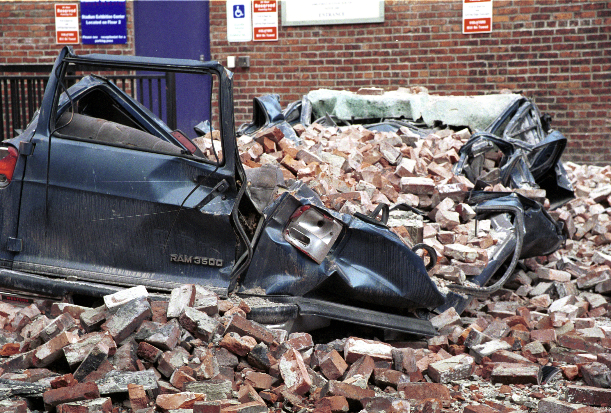
Thankfully not quite. To be sure, some neighborhoods, especially ones near creeks, were hit very hard, but if you were to drive through Boulder right now, you'd see a pretty functioning city, the only unusual sight being the large amount of mud and debris in the streets. Also, thankfully many of the people previously unaccounted for have been found safe, and with the nice, dry weather that's arrived, more will hopefully be located soon. So far the death toll across the state is 8. So...not to downplay the magnitude of what has happened (and there is no doubt that many people's lives were impacted), but it's far from Bangladesh, or Katrina, or even Sandy.
-
ExcitableBoy - Posts: 3666
- Joined: Wed Nov 09, 2005 9:33 am
- Thanked: 663 times in 496 posts
Re: Some info on CO flood effects on climbing access
Thanks for putting this in perspective. The evening news seems to show the worst images. In 2001 I was working in Pioneer Square in downtown Seattle during the big earthquake. A building across the street had its brick facade collapse and land on a car. Virtually the only damage in the city. On the national news that one image was played over and over.
-

Bill Reed - Posts: 534
- Joined: Thu Apr 21, 2005 4:46 pm
- Thanked: 78 times in 59 posts
-
AlexeyD - Posts: 2081
- Joined: Thu Jun 06, 2002 11:13 am
- Thanked: 60 times in 48 posts
Re: Some info on CO flood effects on climbing access
Forgot to mention: in addition to the previously-mentioned access problems, both Rocky Mountain National Park and Eldorado Canyon State Park are closed to all visitor use until further notice.
-

Bob Sihler - Forum Moderator
- Posts: 8486
- Joined: Mon Aug 23, 2004 3:20 pm
- Thanked: 2764 times in 1527 posts
Re: Some info on CO flood effects on climbing access
Does anyone know if access to the Indian Peaks at Brainard Lake has been affected? My wife and I were planning a trip out there for Columbus Day Weekend.
"Alcohol is like love. The first kiss is magic, the second is intimate, the third is routine. After that you take the girl's clothes off."
--Terry Lennox, The Long Goodbye (Raymond Chandler)
--Terry Lennox, The Long Goodbye (Raymond Chandler)
-
AlexeyD - Posts: 2081
- Joined: Thu Jun 06, 2002 11:13 am
- Thanked: 60 times in 48 posts
Re: Some info on CO flood effects on climbing access
Bob Sihler wrote:Does anyone know if access to the Indian Peaks at Brainard Lake has been affected? My wife and I were planning a trip out there for Columbus Day Weekend.
You can still get there via US 6, 119 and 72 from Golden. However, it might be a good idea to call the Arapahoe NF ranger station about trail conditions before you had out, as mudslides and other erosion may have taken place. Info here
-

DudeThatMustHurt - Posts: 3914
- Joined: Mon Jul 12, 2004 6:41 pm
- Thanked: 7 times in 6 posts
Re: Some info on CO flood effects on climbing access
Most of boulder canyon is cleaned up, I've done scaling on the worst land slide at magnolia rd, the fence has been fixed and the national guard/CDOT has been cleaning up my mess.
Golden gate canyon has also been reopened to gain access to parts of coal creek canyon.
I've not gotten the task order for poudre or Thompson canyons, they are still obliterated. Contracts to reopen have been issued to excellent companies mainly Kiewit for BTC. Travel should be available within the next 4-6 weeks in most canyons
-
DudeThatMustHurt - Posts: 3914
- Joined: Mon Jul 12, 2004 6:41 pm
- Thanked: 7 times in 6 posts
Re: Some info on CO flood effects on climbing access
AlexeyD wrote:Bob Sihler wrote:Does anyone know if access to the Indian Peaks at Brainard Lake has been affected? My wife and I were planning a trip out there for Columbus Day Weekend.
You can still get there via US 6, 119 and 72 from Golden. However, it might be a good idea to call the Arapahoe NF ranger station about trail conditions before you had out, as mudslides and other erosion may have taken place. Info here
72 is not open to my knowledge
-
AlexeyD - Posts: 2081
- Joined: Thu Jun 06, 2002 11:13 am
- Thanked: 60 times in 48 posts
Re: Some info on CO flood effects on climbing access
DudeThatMustHurt wrote:AlexeyD wrote:Bob Sihler wrote:Does anyone know if access to the Indian Peaks at Brainard Lake has been affected? My wife and I were planning a trip out there for Columbus Day Weekend.
You can still get there via US 6, 119 and 72 from Golden. However, it might be a good idea to call the Arapahoe NF ranger station about trail conditions before you had out, as mudslides and other erosion may have taken place. Info here
72 is not open to my knowledge
I guess my post was a bit confusing...what I meant was that the only was to get to the Indian Peaks area is via a combination of 6, 119 and 72. You're right that 72 is still closed through Coal Creek Canyon, but the portion of it that access Nederland - and, by extension, the Indian Peaks - appears to be open according to this map.
-
Bill Reed - Posts: 534
- Joined: Thu Apr 21, 2005 4:46 pm
- Thanked: 78 times in 59 posts
Re: Some info on CO flood effects on climbing access
On Thursday, 9/26, RMNP announced that 93% of the Park is open, exceptions being noted in this release. http://www.nps.gov/romo/planyourvisit/flood_alert.htm
-
AlexeyD - Posts: 2081
- Joined: Thu Jun 06, 2002 11:13 am
- Thanked: 60 times in 48 posts
Re: Some info on CO flood effects on climbing access
Some more updates and info (as of 9/26): http://www.climbing.com/news/progress-f ... -colorado/
-
DudeThatMustHurt - Posts: 3914
- Joined: Mon Jul 12, 2004 6:41 pm
- Thanked: 7 times in 6 posts
Re: Some info on CO flood effects on climbing access
Was right about 2 hours from Denver to Estes park for anyone thinking of the drive
-
- Related topics
- Replies
- Views
- Last post
-
- Shutdown Effects on RMNP and Indian Peaks
by Bob Sihler » Mon Oct 07, 2013 5:55 pm - 10 Replies
- 4496 Views
- Last post by DudeThatMustHurt

Sat Oct 12, 2013 9:09 pm
- Shutdown Effects on RMNP and Indian Peaks
-
- US 550 access
by Clark_Griswold » Sun Dec 25, 2011 6:24 am - 4 Replies
- 1549 Views
- Last post by Clark_Griswold
Fri Dec 30, 2011 5:36 pm
- US 550 access
-
- Chicago Basin access.
by CastillejaMiniata » Tue Jul 05, 2011 5:12 am - 5 Replies
- 8939 Views
- Last post by PreClovisMan
Thu Dec 04, 2014 8:10 pm
- Chicago Basin access.
-
- no public access to Mount Bros ?
by Niederbayer » Wed Jan 01, 2020 4:53 pm - 3 Replies
- 4377 Views
- Last post by McCannster
Thu Jan 02, 2020 4:49 pm
- no public access to Mount Bros ?
-
- Western access to Storm King
by mattpayne11 » Sun Jul 04, 2010 7:57 pm - 1 Replies
- 1770 Views
- Last post by mattpayne11
Tue Jul 06, 2010 7:44 pm
- Western access to Storm King
Who is online
Users browsing this forum: No registered users and 0 guests