I will be out at Death Valley, RR, and Zion for a couple weeks in April...
The last time I was in Vegas, I used a topo map my brother had for Red Rocks. It wasn't the greatest ever, but it had usable contour lines and showed all of the trails and peaks. I seem to recall seeing it in the shop at the visitor center, though I think my brother got it from the Vegas REI.
Anyway, I can't find the map online with the RR Canyon Interpretive Association and haven't found it elsewhere. Does anyone know of any online source for this map or another decent topo? There doesn't seem to be one from Trails Illustrated.
Thanks for any help.
Red Rock Canyon topo map?
7 posts
Page 1 of 1
-

Bob Sihler - Forum Moderator
- Posts: 8486
- Joined: Mon Aug 23, 2004 3:20 pm
- Thanked: 2763 times in 1527 posts
Red Rock Canyon topo map?
"Alcohol is like love. The first kiss is magic, the second is intimate, the third is routine. After that you take the girl's clothes off."
--Terry Lennox, The Long Goodbye (Raymond Chandler)
--Terry Lennox, The Long Goodbye (Raymond Chandler)
-

Bubba Suess - Posts: 726
- Joined: Tue Oct 04, 2005 9:15 pm
- Thanked: 183 times in 105 posts
Re: Red Rock Canyon topo map?
Not to be lame, but if you would be satisfied with the USGS topo of the area, I would be happy to supply that.
-

Wisdom - Posts: 24
- Joined: Fri Jan 01, 2010 6:37 am
- Thanked: 4 times in 4 posts
Re: Red Rock Canyon topo map?
Green Trails Maps sells one for Red Rock Canyon by Las Vegas. It's labeled "Red Rock Canyon, Map 2474S: Hiking/Biking/Horse Trails." I bought my copy at a local store in that area for $10. The company itself is in Seattle. Use the company name and add a dot com to it for the website.
-

MoapaPk - Posts: 7780
- Joined: Fri May 13, 2005 7:42 pm
- Thanked: 787 times in 519 posts
Re: Red Rock Canyon topo map?
There are many usgs sheets in the area of Red Rock Canyon. There are a few official trails, but they are mainly to the mouths of canyons or across the lower bajadas. Most travel to Red Rock peaks is by unofficial routes, some marked with cairns. Do you know where you might want to go?
I can supply maps with GPS traces to most locations, but topo maps aren't all that much help out there; the detail of a 40' cliff doesn't show up too well on a topo map with 40' contour interval.
I can supply maps with GPS traces to most locations, but topo maps aren't all that much help out there; the detail of a 40' cliff doesn't show up too well on a topo map with 40' contour interval.
-
Bob Sihler - Forum Moderator
- Posts: 8486
- Joined: Mon Aug 23, 2004 3:20 pm
- Thanked: 2763 times in 1527 posts
Re: Red Rock Canyon topo map?
Bubba Suess wrote:Not to be lame, but if you would be satisfied with the USGS topo of the area, I would be happy to supply that.
Do you mean the quads? I can get those easily enough here. What I'm looking for is an all-in-one map, mainly for locating trailheads and helping ID peaks.
"Alcohol is like love. The first kiss is magic, the second is intimate, the third is routine. After that you take the girl's clothes off."
--Terry Lennox, The Long Goodbye (Raymond Chandler)
--Terry Lennox, The Long Goodbye (Raymond Chandler)
-

Dow Williams - Posts: 2345
- Joined: Mon Jul 12, 2004 1:59 pm
- Thanked: 219 times in 101 posts
Re: Red Rock Canyon topo map?
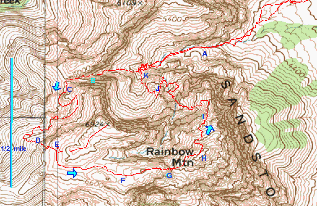
When you do go Bob, make sure to check out the interpretive center (if you havn't already, I think it was open last year this time)....and go out back of the building (easy to miss the outside exhibit)....believe you will be impressed with the simplicity, yet educational bang for their buck on this Fed revamp....rangers inside have various maps available...but in all seriousness, RR is quite contained compared to some of the places you have been...one of the few places I have never needed a map or compass and have always knew where I was going on the approaches..very easy to identify the peaks and canyons as they line right up from the various roads...I have been to the top of every one of them and almost all of them have walk offs and thus scrambles up for the adventurous sort like yourself...cairns are a aplenty. Global Peak is one you want to put on the list....rather remote....more than likely be by yourself and gives you a cool descent...(take a small glacier rope for one short rap so you can enjoy the better of two descents...use my notes from a route called Chuckwalla) Also advise running up Rainbow Mt via Oak Creek, takes you by the George Washington Tower and offers some of the more colorful rock formations. Cheers.
-
MoapaPk - Posts: 7780
- Joined: Fri May 13, 2005 7:42 pm
- Thanked: 787 times in 519 posts
Re: Red Rock Canyon topo map?
Gesu, Rainbow by Oak Creek walk-off is too boring, class 2 and long, suitable mainly for tired rock climbers. Contact us for a good time; Juniper Creek or the down-climb along the east face:
http://hwstock.org/rainb.gif
http://hwstock.org/rainb.gif
7 posts
Page 1 of 1
-
- Related topics
- Replies
- Views
- Last post
-
- Route recommendations for Red Rock Canyon (5.9 and under)
by TimmyC » Fri Nov 23, 2012 7:58 pm - 2 Replies
- 3174 Views
- Last post by rasgoat

Sat Nov 24, 2012 6:27 pm
- Route recommendations for Red Rock Canyon (5.9 and under)
-
- Current Winter Conditions-- Red Rock Canyon
by Bob Sihler » Mon Jan 27, 2014 9:42 pm - 2 Replies
- 4009 Views
- Last post by MoapaPk
Wed Jan 29, 2014 8:39 pm
- Current Winter Conditions-- Red Rock Canyon
-
- Red Rock Scramble
by Kap » Sun Feb 21, 2010 12:46 pm - 6 Replies
- 6242 Views
- Last post by fossana
Tue Feb 23, 2010 3:56 am
- Red Rock Scramble
-
- Red Rock scrambling in April
by tbaranski » Tue Mar 06, 2018 11:28 pm - 0 Replies
- 3089 Views
- Last post by tbaranski
Tue Mar 06, 2018 11:28 pm
- Red Rock scrambling in April
-
- Red Rock in late may - too hot?
by bdynkin » Tue Apr 13, 2010 2:03 pm - 6 Replies
- 4805 Views
- Last post by Dow Williams
Wed Apr 14, 2010 3:24 am
- Red Rock in late may - too hot?
Who is online
Users browsing this forum: No registered users and 0 guests