Sierra Nevada Red Lake Trailhead
9 posts
Page 1 of 1
-

dakine - Posts: 7
- Joined: Tue Sep 17, 2013 9:23 pm
- Thanked: 1 time in 1 post
Sierra Nevada Red Lake Trailhead
I'm planning to climb Split Mountain overnight sometime during the week of Aug 11. I drive a passenger car which won't make it to the trailhead. What is the best option if I can't get a lift from someone w/4wd? (I will trade a case of beer for a lift!) I've been to Tinnemaha campground, maybe drive Fuller road as far as I can and hike in? Is the creek on private land? Any suggestions would be great. (I might bribe one of the ATV enthusiasts at the campground for a lift). Thanks!
-

seano - Posts: 490
- Joined: Tue Mar 11, 2008 4:52 pm
- Thanked: 132 times in 110 posts
Re: Sierra Nevada Red Lake Trailhead
A friend and I made it from the Tinemaha CG to the junction with the other road in a VW Golf a few years back, but I had to walk in front and clear rocks for the last bit. You'll get closer that way than coming in from the Glacier Lodge road, but still face a few hot miles to/from the trailhead. From driving it last year, it looked like there was plenty of parking off private property.
-

MCGusto - Posts: 398
- Joined: Tue Mar 29, 2005 7:18 pm
- Thanked: 20 times in 10 posts
Re: Sierra Nevada Red Lake Trailhead
I was up there just a month ago and searched a lot on the web about getting to the trailhead before heading up there...
From Tinemaha Campground you'll definitely be closer, but MAN that would be a long, HOT walk! When we passed through there, there were only some family campers and 4x4 people around. The campground is in a really weird spot to begin with.... not sure on getting a ride from there.
We actually went in through Glacier Lodge with a 4x2 Tundra, and most of the road is pretty well graded up to the meadow, but MAN, after that.... it's pretty rocky and we were glad to have the clearance of the Tundra (around 10 inches). I would NOT recommend going that way, seeing as the road drops WAY back along the creek.
We exited via Tinemaha, skirting the private land on the ROCKY road up to the mining hill, then basically looping around the mining operation (pretty well graded dirt road), out to Tinemaha campround and 395. Even though I'm pretty sure you could probably take a passenger car up around the mining hill, I don't know if you would want to leave your car over there. The sign on the way in indicates "Locked Gates Ahead" and "Private Property," but with the exception of some OLD fences, it's anybody's guess as to where the property lines are. The roads around the mining hill look pretty well traveled, and we saw some building along the backside, so it's pretty likely people travel that road often... Do THEY know where the property lines are...?????
I'm a pretty avid mountain biker, and I supposed you could probably mountain bike the road around the mining operation and up to Red Lake, but no doubt that road is one rocky mess. I'm talking 5mph in a Tundra and bouncing all over the place. (Probably faster on a mountain bike, now that I think about it). Then you could just leave your bike locked up at the trailhead. Of course, you would want to do this around 4am, because that whole area just bakes in the sun. We got to the trailhead at noon and it was in the 90s, and that was at 6000 feet!
FYI: When you actually get to the trailhead, keep in mind the parking area is NOT where the trail is. If you're facing the mountains from where people park, there'll be a patch of willows to your right (and a dirt road). Follow that dirt road to the patch of willows and start walking up the big hill. Oh, and don't expect to see a trailhead sign.
Good luck.
p.s. Best option: Rent a jeep for a couple of days.
-

SJD - Posts: 571
- Joined: Sat Nov 09, 2002 12:43 pm
- Thanked: 28 times in 22 posts
Re: Sierra Nevada Red Lake Trailhead
I drove to the Red Lake trail head in November of 2012. Don't know how much it has changed since, but the road then was not as bad as I expected (and I drove it at night no less). I was driving an Xtrerra - while the tires would be bigger than most passenger cars, I never had to put the thing into 4WD or do any crazy maneuvers. There are three images I posted to the Split mtn. page showing the route I took. Of course YMMV, just wanted to offer my perspective. Good luck.
PS. Kind of funny they call that a trail.
PS. Kind of funny they call that a trail.
-
dakine - Posts: 7
- Joined: Tue Sep 17, 2013 9:23 pm
- Thanked: 1 time in 1 post
Re: Sierra Nevada Red Lake Trailhead
Well I figured that since John Muir walked from Independence to the top of Mt. Williamson, I should be able to walk a couple of miles to Red Lake TH.
I've stayed at Tinnemaha campground and the ATV folks are nice. Good place to hear RV generators run at night, motorcycles zipping by, and a gun range conveniently nearby.
Hopefully I'll find someone heading up that way to share a ride. I'll follow up after the trip. Thanks for the info.
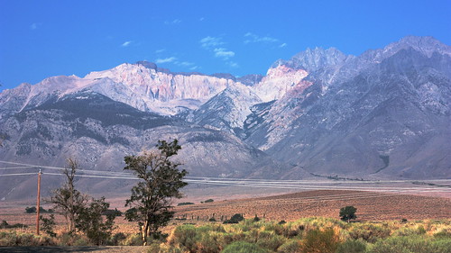
Here's a photo of my Tinnemaha campsite last summer during the big monsoon:
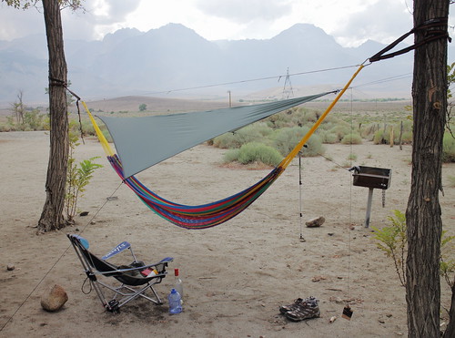
Sunrise:
I've stayed at Tinnemaha campground and the ATV folks are nice. Good place to hear RV generators run at night, motorcycles zipping by, and a gun range conveniently nearby.
Hopefully I'll find someone heading up that way to share a ride. I'll follow up after the trip. Thanks for the info.
Here's a photo of my Tinnemaha campsite last summer during the big monsoon:
Sunrise:
-

DougHemken - Posts: 6
- Joined: Tue Mar 24, 2009 8:58 pm
- Thanked: 0 time in 0 post
Re: Sierra Nevada Red Lake Trailhead
We parked at McMurry Meadow and hiked cross-country to the trailhead, only added a couple of miles. Not too hot in the morning/evening.
-

artirm - Posts: 30
- Joined: Tue May 18, 2010 6:41 am
- Thanked: 5 times in 4 posts
Re: Sierra Nevada Red Lake Trailhead
I made it to the trailhead in my Honda Element. Element has probably the lowest clearance among cross-overs, so I'd give it a try. Really bad road only begins 4-5 miles away from the trailhead and if you are not worried about your undercarriage too much, it should be fine.
P.S. I took my Sentra to the Basin Mountain trailhead, it was never the same after that
P.S. I took my Sentra to the Basin Mountain trailhead, it was never the same after that
-

MoapaPk - Posts: 7780
- Joined: Fri May 13, 2005 7:42 pm
- Thanked: 787 times in 519 posts
Re: Sierra Nevada Red Lake Trailhead
This road varies a A LOT year to year. The year I drove in (2006) there was a low-clearance 2wd car at the TH. But he didn't make it back out.
-
willytinawin - Posts: 105
- Joined: Fri Feb 13, 2009 3:03 am
- Thanked: 86 times in 71 posts
Re: Sierra Nevada Red Lake Trailhead
I've done it a few times. The most memorable was in a VW bus from the 60s, we got out and did some roadwork a few times, and we made it. The easiest time was in a chevy blazer. Once I was in a honda civic, so I parked at McMurray meadow and hiked directly to the trailhead in a little over an hour. Always fun though.
9 posts
Page 1 of 1
-
- Related topics
- Replies
- Views
- Last post
-
- Camera Found at Red Lake Trailhead
by cab » Mon Jul 12, 2010 8:01 pm - 0 Replies
- 1065 Views
- Last post by cab

Mon Jul 12, 2010 8:01 pm
- Camera Found at Red Lake Trailhead
-
- Road to Red Lake/Split Mountain Trailhead
by Ambret » Sat Aug 01, 2015 11:26 pm - 4 Replies
- 2208 Views
- Last post by Ambret
Wed Aug 05, 2015 11:46 pm
- Road to Red Lake/Split Mountain Trailhead
-
- Sighting of Sierra Nevada Red Fox reported
by EManBevHills » Tue Sep 07, 2010 7:41 pm - 2 Replies
- 1353 Views
- Last post by Mark M
Wed Sep 08, 2010 2:50 am
- Sighting of Sierra Nevada Red Fox reported
-
- Sierra Buttes Trailhead/packer lake conditions...
by yosemiteforlife67 » Sat Jun 18, 2011 10:43 pm - 5 Replies
- 3099 Views
- Last post by Vladislav
Wed Jul 13, 2011 7:28 pm
- Sierra Buttes Trailhead/packer lake conditions...
-
- South Lake/Bishop Pass Trailhead
by Bascuela » Thu Jul 01, 2010 11:18 pm - 7 Replies
- 3210 Views
- Last post by fossana
Fri Jul 02, 2010 10:16 pm
- South Lake/Bishop Pass Trailhead
Who is online
Users browsing this forum: No registered users and 0 guests