
|
|
Mountain/Rock |
|---|---|
|
|
32.33298°N / 106.88202°W |
|
|
Dona Ana |
|
|
Hiking |
|
|
Spring, Summer, Fall, Winter |
|
|
4959 ft / 1512 m |
|
|
Overview
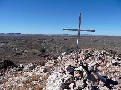
Picacho Peak is located 7 miles from downtown Las Cruces, New Mexico, on the West Mesa adjacent to Picacho Peak Recreation Area. The Mountain features spectacular views of the New Mexico and Las Cruces landscape in every direction. The Picacho Hills Country Club and several housing developments are located on the South side of the peak, while the Robledos Mountains sit toward the North.
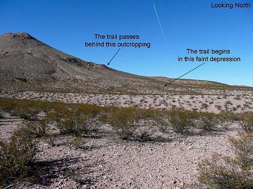
There are no facilities there yet, but "the peak" welcomes hikers, bikers or horseback riders. The vegetation is sparse so picking a path is an easy option, but there is an improved trail that starts halfway up the mountain. It's not well marked, but can be seen from the south side of the mountain. The fire road you see from town (looking west) does not go to the top...
Getting There
There are many ways to approach Picacho Peak, but the increasing housing developments are making access more difficult. These directions will get you to a developed access point surrounded by several gated communities.
Take highway 70 West, cross the Rio Grande and turn right on Picacho Hills Drive. Turn North on Villa Norte, then West (left) on Vista del Rieno. Turn North (right) on Vista del Cerro and follow it a few hundred yards to it's dead end. It's hard to see the access through the stone wall, but it's there. Just park along the curb.
Red Tape
Currently Picacho Peak is on BLM land, but Las Cruces is growing rapidly and land management can change quickly. Most of the open land just behind the housing developments is within city limits.
Camping
There are no improved sites in the area.
External Links
Add External Links text here.