-
 7969 Hits
-
 78.27% Score
-
 9 Votes
|
|
Mountain/Rock |
|---|---|
|
|
22.0426°S / 44.6417°W |
|
|
Hiking, Mountaineering, Big Wall |
|
|
Spring, Summer, Fall, Winter |
|
|
6906 ft / 2105 m |
|
|
Overview

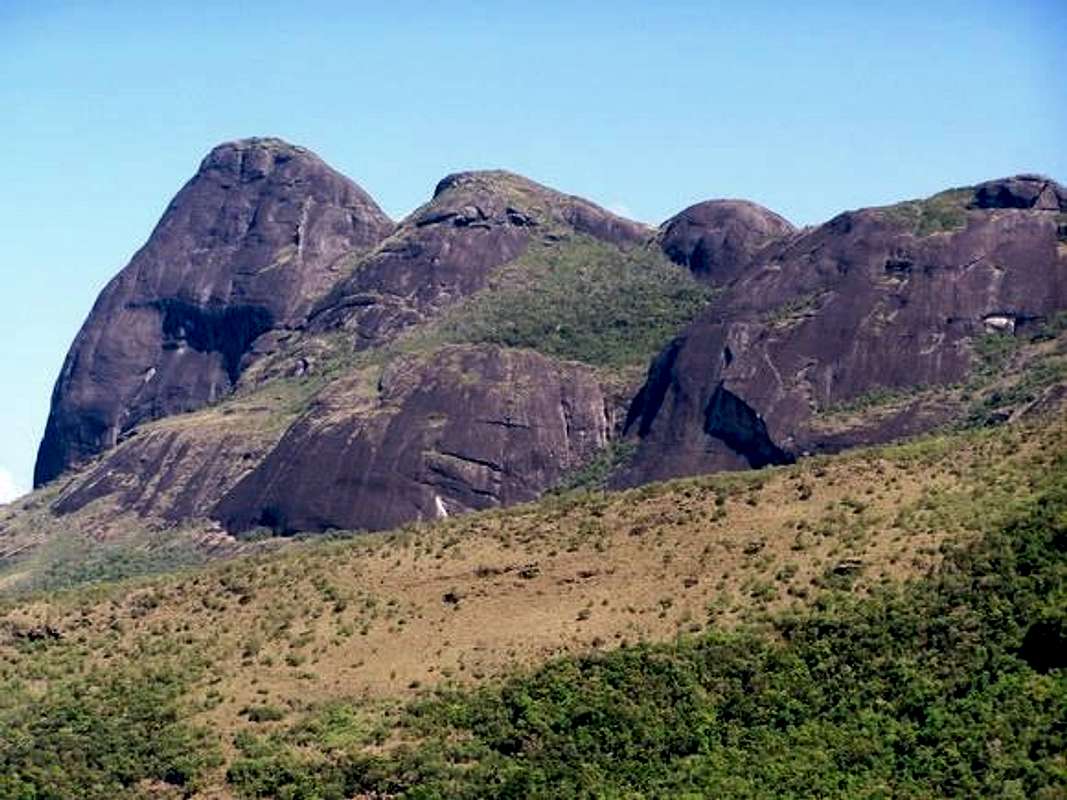
Pico do Papagaio (2293m) ( Parrot Peak ) is localized in the southwest portion of Minas Gerais State, Brazilian Southeast Region. This mountain is one of many mountain with around 2300m of Serra da Mantiqueira backcountry border, how Mitra do Bispo 2149m ( Bishop Mitre Peak ) and Alto do Bandeira 2357m ( Bandeira Mount ). The main feature of this mountains is the rounded form, because the formation is dated of more than 1 bilion years old. The region that localizes this peaks is called Aiuruoca ( Parrot Nest – Tupi Guarani language ) with many rivers, waterfalls, altitude fields and beautiful mountains. Land of legends, dwarfs, fairies and flying saucers, this group of mountains is possible to be seen from Itatiaia National Park, Pedra da Mina and Pico dos Marins. Pico do Papagaio is the foundation symbol of Aiuruoca town, naming a lot of estabilishments and stores around the mountain. Serra do Papagaio turned State Park in August 5, 1998, by the designation N° 39.793, changing to Integral Protection Unity – Parque Estadual da Serra do Papagaio ( Serra do Papagaio State Park ). The S, E and N side of Papagaio have an impressive big wall ( around 500m ), perfect to practice rappel and technical climbing.
Getting There
Pico do Papagaio is almost in the middle way of Rio X São Paulo, the biggest brazilian cities. The south Minas Gerais is a beautiful land, with many mountains, farms, great rivers and confortable little towns and villages.From São Paulo, Take the BR-381 to Belo Horizonte ( Minas Gerais Capital ) till São Gonçalo do Sapucaí town. After this small village, take the BR-267 to Aiuruoca ( plates denotes the exact way )
São Paulo – Aiuruoca : 402 km
From Rio de Janeiro, take the BR-116 till Engenheiro Passos district ( the same way to Agulhas Negras ) but you have to continue driving to Caxambu town ( 80 km after the entrance to INP ). Caxambu is the last town before Aiuruoca ( 45 km of distance ).
Rio de Janeiro - Aiuruoca : 317 km
Arriving in Aiuruoca:
When arrive in the little town of Aiuruoca, ask or seek the way to Matutu Reserve, because there is the trailhead. It’s very easy to find the right way ! Ask to anyone that live in this town and, they tell you whole way to get the summit of Papagaio. Matutu is a forest reserve with much green , rivers and waterfalls in the base of the mountains of Serra do Papagaio. At Matutu Reserve, you’ll see the rock formations at south side of Aiuruoca ( From all Aiuruoca region is possible to see the way to Pico do Papagaio ). The road to Matutu is called Retiro dos Pedros road ( unpaved ) and this one carry to the Gamarra Valley ( 2000m ), the last place to stop your 4X4. It’s possible to rent horses and ride to the summit of Alto do Bandeira ( 2357m ). At Gamarra Valley, you can choose where to go : To the right, Alto da Bandeira and, to the left, Cabeça do Leão ( Lion’s Head – 2135m ) and Pico do Papagaio ( 2293m ).
From Aiuruoca:
- Retiro dos Pedros: 4 km
- Alto do Bandeira : 5 km
- Pico do Papagaio : 8 km
Aiuruoca and the Metropolis of Rio , São Paulo and Belo Horizonte

MSN Mappoint - Aiuruoca
Red Tape
There aren’t fees to get into the Papagaio State Park;Guides are advisable;
It’s possible to reach the high plateau by horses. Contract the guide , ride and save your time to get the summit;
4X4 is another way to get the high plateau.
Cell phone signal in the high of the mountains is possible, but very rare.
Do not leave your waste inside the State Park !
When To Climb
Pico do Papagaio and adjacencies are in the Brazilian Highlands ( the coldest region in Brazil ) then, the best season to go to this mountain is at Winter. Low temperatures records are in this season. October to March is the wet season, because the forest is very moist, afrronting rainstorm clouds.Aiuruoca current weather

Camping
There aren’t official campsites. It’s possible to camp anywhere you think that it is safe. The best places to camp are: Matutu Reserve, Gamarra Valley, Alto do Bandeira, Retiro dos Pedros and at Pico do Papagaio.Hotels in Aiuruoca:
Hotels
Mountain Conditions
The trails to the high Serra do Papagaio are very used, so, is very clear and easy to find any way over there. There aren’t webcams of Pico do Papagaio. At wet season, the trails turn very steep and muddy, and I recommend good shoes to walk on this terrain. Over the top, be careful with rainstorms and thunderbolts, the peak is extreme exposed.Credits
Credits to Hugo Pereira for all photos to construct this page.Thanks a lot.


