
|
|
Mountain/Rock |
|---|---|
|
|
33.98700°N / 111.4359°W |
|
|
Maricopa and Gila |
|
|
Hiking |
|
|
6420 ft / 1957 m |
|
|
Overview
Pine Butte is a relatively obscure mountain summit across the Beeline Highway from Mount Ord. Despite its accessibility, it is rarely hiked. Getting there is easy, but finishing is the tough part. The final summit push involves 325’ of hiking through pretty thick brush. It’s doable, but quite challenging.
The summit of Pine Butte sits along the border of Gila County and Maricopa County. It isn’t really that far from the edge of the Phoenix valley. However, the topography is quite different. The road leading to Pine Butte is a well-graded dirt road. 4WD is recommended if venturing deep into the wilderness.
The road allows exploration of the wider area and leads into the Mazatzal Wilderness. The road ends at the Mount Peeley Trailhead. Pine Butte is accessed about 4 miles from the trailhead.
Pine Butte is best hiked outside of summer months. Although it is higher than mountains in Phoenix, the bushwhacking required to reach the summit makes it better suited for colder weather months. October through April are recommended times. If hiking in October, start early, and the same for April. Pine Butte can get snow in the heart of winter or even up until March, which is what occurred in mid-March 2021. However, March is usually a pretty safe bet for excellent weather for this mountain.

Getting There
Pine Butte is accessed from off the Beeline Highway. The entrance road is right across from the road to Mount Ord. It is over 30 miles from the junction with Shea Blvd and Highway 87 in Fountain Hills to the turn-off to Forest Road 626, which is paved. Take the road for 1.2 miles until you see a dirt road on the right. This is FS Road 201. Take it for 1.2 miles. This road is absolutely fine for 2WD. There is space for parking on the right. While 2WD could probably make it further up the road in good conditions, we found this to be a good starting point for Pine Butte.
Route
The route information being described is based on a starting point at the 2WD trailhead noted above. From the parking area, the turn off to Pine Butte is about three and one third miles along Forest Road 201.
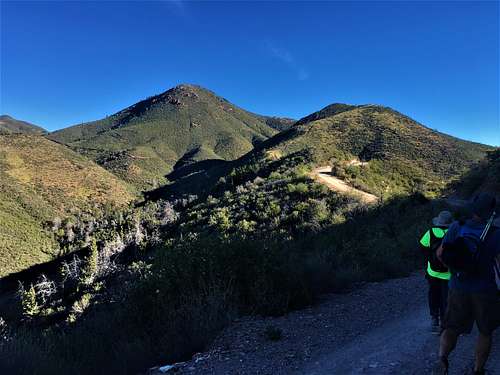 Group walking towards Pine Butte
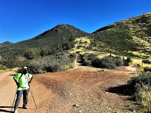 At the base of the jeep road that leads to Pine Butte
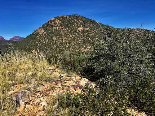
Once at the turn off, there is a steep jeep road. It climbs about 400’ in a quarter of a mile. From there, the bushwhack begins. There are generally some open spots. However, you will need to try and follow these spots with caution. Stay generally on the top of the ridge, and avoid temptation to go to the side. This is the path of least resistance. After nearly half a mile of this bushwhacking, you reach the base of the summit block. It is 325’ from here through thick brush to the summit; in only two-tenths of a mile.
 Final stretch to the summit
The best approach is to go straight up. It isn’t that clear, and you will have to go through some thick brush. However, once at the summit, there are some pretty nice views.
The total distance is 4.5 miles, gaining nearly 2,400'. However, if driving to the base of the jeep road, it is one and a quarter miles to the summit, gaining about 1,250'.
Red Tape
There is no red tape in particular. Pine Butte is in the Tonto National Forest. Be mindful of any fire restrictions. Due to the bushwhacking, it is recommended that hikers wear long pants.