|
|
Mountain/Rock |
|---|---|
|
|
48.55013°N / 120.73616°W |
|
|
Download GPX » View Route on Map |
|
|
skagit |
|
|
Mountaineering, Trad Climbing, Scrambling, Skiing |
|
|
Spring, Summer |
|
|
7762 ft / 2366 m |
|
|

John Roper's picture of westside
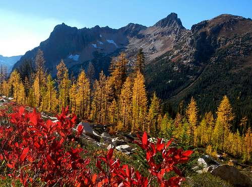
Fall Colors Porcupine Peak
Overview
Porcupine Peak is a mostly unknown peak in the cascades with only a handful of summit attempts, most of them in the last seven years. The mountain is located just one mile from Hwy 20, northwest of Cutthroat Peak, across Porcupine Creek, and southeast of Mount Hardy.![The view ENE on Oct. 6, 1996:...]()
C:swamp creek parking, D:Hwy 20, E: Porcupine creek, 14:cutthroat, 1: Mt. Hardy Connected to the other mountains by a steep and ragged ridge of little porcupines. The mountain itself is a stooping triangular prism, placed atop a system of ridges and spires, made of that eroding orange Washington pass Granite. From the Southwest it looks as if it's a impenetrable fortress of rock, but from the eastside its more welcoming with a mellow basin,and only the pyramid to climb.
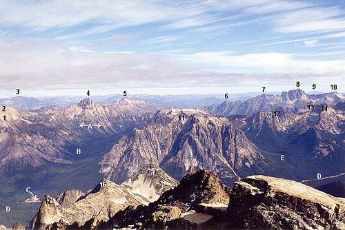
C:swamp creek parking, D:Hwy 20, E: Porcupine creek, 14:cutthroat, 1: Mt. Hardy
Statistics:
Porcupine peak has an elevation of 7,762, and prominence of 922 feet.
Isolation is 2.24 miles, the peaks has two notable sub peaks, three ridges, and 6 major ribs. One established route, east basin. Any other routes used would be first ascents. But most other routes with have a YDS class above 4.
Getting There
There are to main ways the peak is accessed, the most commonly used is to take the Cascade Highway to the rainy pass trailhead for the Pacific Crest Trail heading north, maintained parking lot with toilets nearby. The second access point is less used and is not a trailhead, the swamp creek route access is located at 4000 feet, hard to miss, large open area no trees, with large pullout near swamp creek, from the east if you pass swamp creek you've gone to far, from the west If you are passing the mountain you've gone to far. This route has no trail except for large number of ribbons noted 2004.
Route

John Roper's Picture of north face
Main east basin route:
The most popular route is the east basin route, mind you that only about a few dozen people have used that route.. Start from the rainy pass trailhead take the PCT north, cross porcupine creek continue to an elevation of 5600 feet or until you reach a open avalanche path with small trees and talus. Leave the trail and travel up the slope travel about a quarter mile until you reach a headwall with a flat meadow at the confluence of two streams, this is the main camp. Now north below the headwall until you can easily ascend the slope along a drainage. Continue along the creek until you reach the upper basin, now travel upward toward a col between the main summit and a small sub peak. Now you can climb the summit via the ledges or the ridge mostly class 3 parts are class 4. limited Rope use recommend.Swamp creek and lake route:
The route of the forgotten lake, this route is almost never used on of the few lakes near Washington pass with NO people. From the Swamp Creek assess point Travel along the drainage, not in the drainage for about 0.8 miles until you come around the side of the mountain and come to an area with a mellow slope heading up along side the mountain, but vear a little more to the north staying on the north side of the lake drainage continue until you reach the lake. The camping is along the mouth of the lake. To go to the summit stay on the south side of the lake, follow a mellow shoulder above the lake, keep following the shoulder until you reach this flat bench, from here travel along the bench north, stop before you drop down to the tarn. Here it should be pretty easy to reach the ridge follow the ridge to the summit. Class unknown, mostly likely the northeast ridge has never been climbed.
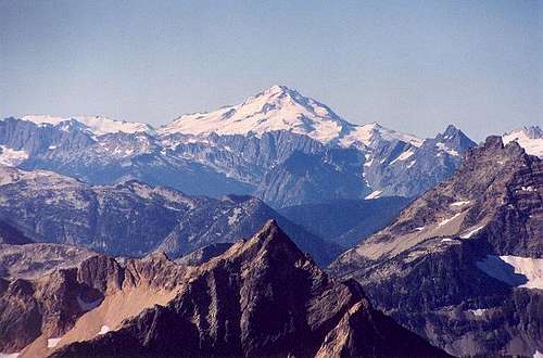
The Unknown Routes: ![Glacier Peak from the NNE...]()
Upper face, note chimney, and steep ledge on left, and dead space of the right. Also how the face goes over the slot in the right, upper east ridge on the left.
Upper face, note chimney, and steep ledge on left, and dead space of the right. Also how the face goes over the slot in the right, upper east ridge on the left.
These are the routes that there is no information on, and most likely never climbed. The most notable Would be the North Face with a upper and low wall, with a deep canyon like slot running down the middle. In some picture it looks like the upper wall has roof inside the slot. The upper wall is a smooth face about 900 feet tall, and the lower wall is 1200 feet of slabs, probably easier to protect though, upper face has a lot of dead space. The easiest route would be taking the chimney to the ledge, but you would have to do with any roof in the slot. Other routes could be the west ridge shown is picture above probably kinda like a Hozomeen Southwest buttress maybe easier(no cave). Another route could be the canyon slots, and east ridge, or even a route up the grueling west side ribs. Overall the route opportunities are great, but were skipped over because porcupine is too short.
*Note these being unclimbed route, means no guarantee any route Ideas stated above, are the best ways or will even work.
Red Tape and conditions
No permit is needed to climb Porcupine peak, but a Northwest Forest pass is needed to park at the Rainy pass trailhead, and the Swamp creek route pullout, is not really a trailhead, but bringing a Northwest Forest pass is recommend, the pullout it self is effey, people have park there, but current polices are unknown.
Conditions: Hwy 20 is closed during the winter, and is usually open only may to November, check conditions before traveling.
When to Climb
The best time to climb the mountain would be from late-June to early September, most of the snow should be gone and rocks should have no snow on the final scramble, but earlier is better, snow in the very upper basin is helpful covers all this small sized talus. Although The west porcupine basin route could be taken by skis during May, actual climbing the rocky summit may be difficult, especially in touring boots.
Camping
Although the main route can usually be done in a long full day, there is camping available ![Fall Colors Porcupine Peak]()
West basin of Porcupine Peak
West basin of Porcupine Peak
Camping on the east side:
The best place for camping when a tent is used is a small meadow at the confluence of two small creeks that become the main drainage at latitude 48°32'47.04"N and longitude 120°43'30.69"W, below the headwall at 5880 feet. Space is limited, just maybe two 2-person parties, or one large party. Another tent area might work at 6238 feet at a latitude 48°32'49.08"N and longitude 120°43'39.09"W. Site is located above the headwall near the first camp. These are the only flat areas suitable for tent camping, other areas probably with facilitate bevy camping.
Camping on the west side:
The best place for camping on the west side is at Porcupine lake(not labeled on maps) at 5895 feet, at a latitude of 48°33'28.48"N and a longitude of 120°43'57.72"W. N Space for maybe four small parties, and two large parties. Another area is a small flatish bench above a small tarn at 6647 feet, at a latitude of 48°33'18.50"N and longitude of 120°43'32.92"W, might fit one small party in tent, bevy spots possible along other parts of bench. Warning this site is near large talus field and cliff face there could be failing rocks! Other possible camping areas are below the lake, and below the north faces, these areas are less flat and less open.
*Note there is no established camping sites, just areas used occasionally, mostly on the eastside.
Campground camping: cost 8-16$
Nearest campground on the eastside of the pass is Lone fir(12.7 miles), and the nearest on the westside is Colonial creek(25.1 miles)16$.
Other campgrounds
East: Kilpchuck(21.1 miles), Early Winters(22.5 miles)8$, and Gate Creek(4.3 miles up lost River road)
West: Gorge Lake Campground(29.7 miles), and Goodell campground (35.8 miles)16$.
Hotels and cabins: cost 40-200$
East:North cascades Basecamp(26.7 miles)+85$, Mazama County Inn(24.9 miles)+85$, and North cascades Hostel(37.7 miles)+40$
West: Totem trail(52.4 miles)+50$, Buffalo Run Inn(49.1 miles)+54$
*slow season lowest prices current of June 2015
hgrapid - Jun 27, 2015 2:28 am - Voted 9/10
Great page, but caught a missing noteNice work! One thing I noticed. You wrote "The most popular route is the east basin route, mind you that only about a dozen people." Did you mean to write that only about a dozen people have ever done this route?
jacgoat - Jun 27, 2015 2:42 pm - Hasn't voted
Re: Great page, but caught a missing noteYes, I'll fix that.