
|
|
Mountain/Rock |
|---|---|
|
|
41.68109°N / 116.1366°W |
|
|
Elko |
|
|
9268 ft / 2825 m |
|
|
Overview


Whether you’re a prominence peak bagger, range high point chaser, or just want to get out for a pleasant hike in a beautiful and remote area, Porter Peak fits the bill. Tucked away in the Bull Run Mountains (formerly the Centennial Range) about 60 miles north of Elko in remote northern Nevada, Porter Peak, the range high point at 9,268 feet elevation, has a prominence of 2,662 feet, placing it #91 on the list of Nevada’s 100 most prominent peaks. I don’t know anything about the naming of the peak. In the 1870s, the Porter Mine was one of the main mines in White Rock Canyon, near Porter Peak.
The Bull Run Mountains trend north-south for 25 miles, bounded to the north by the Owyhee River and to the south by Deep Creek. I was somewhat caught off guard by the rugged beauty of this obscure Great Basin range. It contains the sagebrush and steppe grasslands typical of the area, but also has abundant aspen woodlands in the moderate elevations and subalpine fir woodlands in the upper elevations.
The driving route into the Bull Run Mountains passes through private lands as well as public lands administered by both the Bureau of Land Management (BLM) and the U.S. Forest Service (USFS). The central section of the Bull Run Mountains, including the upper reaches of Porter Peak, falls predominantly on USFS lands. Access into this area is not restricted.
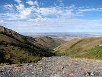
The summit is large and flat, and while you’re not likely to host a huge party there (even though there’s plenty of room for it), you can take in some magnificent views of remote northern Nevada. Among these great views are the nearby Independence Mountains to the southeast, the Owyhee and YP Deserts to the west and northwest, respectively, and, of course, the home range, the Bull Runs, in which Porter Peak is situated in the interior. On the east end of this large summit is the high point, where a glass jar containing a summit register is tucked into the rocks. As with many prominence peaks in this area, the register was placed by Gordon MacLeod and Barbara Lilley of Simi Valley, California. There was also a third person, Bill Sanders, of Redondo Beach, California, present for the inauguration of this register. The register, placed on the summit in August 1998, had only six signatures in the past 11 years. This to me seems rather unusual considering the peak’s credentials (2k prominence, Top 100, range HP) coupled with the ease of access. Please see the Getting There section for more info on access and directions.
 Bull Run Mountains interior. Bull Run Mountains interior. |
 White Rock Canyon and beyond. White Rock Canyon and beyond. |
 White Rock Canyon view. White Rock Canyon view. |
 Summit view to east-northeast. Summit view to east-northeast. |
 Summit view to northwest. Summit view to northwest. |
 Bull Run Basin. Bull Run Basin. |
Getting There

From NV-225 22 miles north of Elko in northeastern Nevada, head west and then north on NV-226 for about 40 miles until you reach a Y-intersection. This is where NV-226 ends and the road goes from pavement to gravel. Go left at this intersection and drive west for about 3.8 miles on County Highway 730. Turn right at the intersection onto County Highway 728 and head north for about 11.4 miles. On the early part of this northerly leg, you’ll see the BLM sign and prominent Wilson Peak (see photo above).
Turn right onto Forest Service Road 169 and head east along White Rock Creek towards the Bull Run Mountains. Two abandoned structures -- one to the left and one to the right of FS169 – indicate that you’re on track. At a point roughly 1.3 miles north of Porter Peak, FS169 becomes a 4WD road . One of the nice things is that you can drive in to a point just below the summit on the north side (hike would be 200 or so yards), so depending on factors such as physical limitations, time, etc., this peak can be done by most people. If you want to lengthen your hike, that option is also on the table as there are several opportunities to pull out along FS169 or the 4WD road and then you can simply hike the road to Porter Peak. I parked on the saddle just south of Blue Jacket Peak and began my hike there, which was a total of 4.1 miles traveled on FS169 and the 4WD road. Please refer to the map below for more route details.
FS169 and the 4WD road are in very good condition. I did not see any problem areas along the route that would require 4WD or high clearance.

 NV-226 Y-intersection. NV-226 Y-intersection. |
 FS169 view. FS169 view. |
 4WD road. 4WD road. |
Route

From the parking point south of Blue Jacket Peak, you can just see the summit of Porter Peak peeking above the crest to the south. Hike the 4WD road south and when you reach the intersection about one half mile due north of Porter Peak, go left. Leave the road and hike up the slope to gain the saddle to the right – or northwest -- of Porter Peak. Upon gaining the saddle, proceed southeast to the summit.
The route from the saddle just south of Blue Jacket Peak is 3.7 miles round trip with 960 feet of net elevation gain. Gross gain is 1,160 feet on ascent and 200 feet on descent for a total gross elevation gain of 1,350 feet.
 View back to route start. View back to route start. |
 Route view. Route view. |
 Approaching Porter Peak, left. Approaching Porter Peak, left. |
 Downslope view. Downslope view. |
 View from the saddle. View from the saddle. |
 Approaching the summit Approaching the summit |
Maps
USGS Quad (7.5’ scale) – Bull Run ReservoirOrder online
BLM Surface Management Status Quad (1:100K scale) – Bull Run Mountains
Order through BLM at 775-753-0200 or online
USFS Humboldt-Toiyabe National Forest, Mountain City & Jarbidge Ranger District
Order through USFS at 775-738-5171 or online
Dean - Aug 26, 2011 6:26 pm - Voted 10/10
No food, no gas = Mountain CityAlmost every business in Mountain City is closed down except for a motel. The nearest gas is either Elko or north on the Indian reservation as you head toward Mountain Home. Make sure you have plenty of gas prior to leaving for this one.