
|
|
Area/Range |
|---|---|
|
|
50.23315°N / 116.47705°W |
|
|
Hiking, Mountaineering, Trad Climbing, Ice Climbing, Aid Climbing, Big Wall, Mixed, Scrambling, Skiing |
|
|
Spring, Summer, Fall, Winter |
|
|
Overview
The Purcell Mountains are a roughly 300-mile-long mountain range extending across southeastern British Columbia, from near the town of Golden, BC, and into northwestern Montana and northern Idaho. In the United States, the Purcells are considered to be a subrange of the Rocky Mountains, but in Canada they are considered to be separate range. The Canadian Purcells lie between the Canadian Rockies to the east and the Selkirks to the west. They are bounded immediately by the Columbia Trench on the east, and the basin of Kootenay Lake on the west. Three provincial parks are located in the Purcell Mountains. From south to north, these are: the St. Mary's Alpine Wilderness, the Purcell Wilderness Conservancy, and the Bugaboo Provincial Park. The remainder of this page will deal only with the Canadian portion of the Purcell Mountains.
Major Peaks and Subgroups
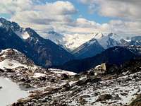
In general, the Purcells become higher, more rugged, and more glaciated as one travels north along the range. South of the St. Mary's Alpine Wilderness, the Purcells consist of largely tree-covered, relatively gentle mountains, similar in character to other ranges in the Idaho Panhandle, eastern Washington and far northwest Montana. Beginning in the Alpine Wilderness, and particularly in the Wilderness Conservancy, the Purcells become a spectacular, glacier-clad range of jagged peaks whose grandeur and scale rivals their more famous and frequently visited Rocky Mountain neighbors.
The highest peaks and largest glaciers tend to be clustered in compact subgroups, such as the Jumbo and Commander groups, which contain the largest concentration of summits over 11000 feet. The highest point in the Purcells is Mt. Farnham (11,460 feet or 3,493 meters), which crowns the massive and foreboding Farnham Towers, some of which display over 4000 feet of nearly vertical relief from surrounding basins (a scale comparable to the Trango Towers of Pakistan). Other subranges include the Carbonate Range; the Dogtooths; the Quintet, Sextet and Septet ranges; the MacBeth Group; the Starbird Ridge; the Stockdale Group; the Truce Group and the Spillimachen Range (source: http://en.wikipedia.org/wiki/Purcell_Mountains). In general, peaks in the northern Purcells average around 10,000 feet, whereas treeline lies between 6,500 and 7,500 feet and the summer snowline typically between 8,000 and 9,500 feet, as usual depending on aspect, location relative to the crest (rain shadow effects), time of year, winter snowfall, etc.
A particularly famous subgroup of the Purcells are the Bugaboos - a spectacular collection of granite spires rising from massive icefields, and a world-renowned alpine rock climbing destination. This is the only part of the Purcells that receives significant and regular attention from the climbing community, and consequently includes features such as a hut, route descriptions, regular condition reports, etc. Most other locations in the Purcells are far more remote and undeveloped, and in many cases visitors can expect to be the only ones there.
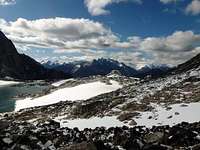
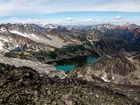
Glaciers
Stockdale Glacier, Purcell Range
As with most mountain ranges in western North America, the major force of nature that has shaped the Purcell Mountains more than anything else in the past 100,000 years has been glaciation. The U-shaped valleys, bowl-like cirques, sculpted horns, aretes and spires, rubble-strewn moraines, and countless blue-green lakes that characterize the Purcells are a testament to this icy legacy. In modern times, hundreds of active glaciers still adorn the high basins and slopes of the Purcells, grinding and sculpting the surrounding landscape. All of the modern-day Purcell glaciers are in the Canadian portion of the range, and nearly all lie north of the St. Mary's Alpine Wilderness. The longest is the Conrad Glacier in the northern Bugaboos, extending about 10 kilometers (6 miles) northward from the Conrad Icefield. Other significant glaciers, from south to north, include: the Toby Glacier; the Truce and Horseshoe Glaciers in the Truce Group; the Macbeth Icefield; the Commander Glacier; the Delphine Glacier; the Starbird Glacier; the Stockdale Glacier; the North Star and Catamount Glaciers; and the Bugaboo and Vowell Glaciers in the Bugaboos. In addition to these and other named bodies of ice, many more small, unnamed hanging glaciers, pocket glaciers and permanent snowfields can be found on the upper slopes of the Purcells. This extensive mantle of permanent snow and ice undoubtedly adds to the splendor of this already magnificent mountain range.
The extent of glaciation in the Purcells varies not only with latitude, elevation and slope aspect, but also with location relative to other mountain ranges or subranges. For example, the Septet Range and the Starbird Ridge are roughly similar in elevation, and lie at nearly the same longtitude, with the former just north of the latter. And yet, the glaciers are much less prevalent and smaller than in the Septet Range than in the Starbird Ridge. This difference is explained by the fact that the Septets lie directly east of the slightly higher Bugaboos, and, as a result, incoming storms from the Pacific lose a significant portion of their moisture by the time they reach the Septets. Similar differences can be observed with other subgroups located on the eastward and westward sides of the main range.
Getting There
Access to the Purcell Mountains is time-consuming, but in many cases fairly simple. Highway 95, which runs north-south along the Rocky Mountain Trench, parallels the range on its eastern side, and numerous mining, logging and forest service roads provide access deep into the heart of the Purcells. Most of these are gravel and dirt roads of varying quality; many are passable by 2-wheel drive vehicles; some require 4WD and/or high clearance. The towns of Skookumchuk, Invermere, Radium Hot Springs, Spillamacheen and Golden provide logistical bases for explorations of the Purcells. Of these, Radium Hot Springs is the largest and offers the most in terms of amenities. Access to the western side of the range is somewhat more complicated, as fewer roads exist, and the seemingly endless Kootenai Lake must be either crossed or circumnavigated prior to entering the mountains. The closest major Canadian city is Calgary, AB, while the closest major American city is Spokane, WA. The former is somewhat closer than the latter, but in either case expect at least 5-6 hours total driving time to most locations in the Purcells.
Weather, Climate and Ecosystem

The Purcells are a continental mountain range with a fairly northerly location (generally above 50 degrees N), and an orientation that is parallel to the Pacific coast. Since they have neighboring ranges on both the east and west sides, they tend to have a climate and weather patterns that is intermediate between these neighbors. In other words, they tend to be wetter (and in the summer, cooler) than the Rockies, but somewhat drier than the Selkirks. In addition, one encounters a significant change in both climate and vegetation as one travels from west to east over the mountains, with the western slopes having a much lusher, sometimes almost maritime appearance with semi-rainforest valleys, while the eastern side features typical interior Western ecosystems of conifer forests and sparse undergrowth. Along the crest itself, the weather can be unpredictable and severe, including summer snowfall as low as 7000 feet (this has been confirmed by the author of this page!). Winter snowfall is typically heavy, and downhill skiing is available at the Panorama Resort (west of Invermere). Other areas in the Purcells are renowned for backcountry and heli-skiing opportunities.
Red Tape
As mentioned before, parts of the Purcells are contained within provincial parks. Visitors to these portions of the mountains should consult the individual parks for rules and regulations, many of which can be particular to the park in question. Other areas lie in lands administered by the Canadian Ministry of Forests; these tend to be minimally regulated, but some regulation may exit, and it's best to check with a ranger station for any local updates, closings, road conditions, etc.
Recreation Opportunities


The Bugaboo subgroup in the Purcells is world-renowned as an alpine rock climbing destination. In addition to the spires, the Bugaboos contain some of the largest glaciers and icefields in the range (such as the expansive Conrad Icefield), and numerous mountaineering and ski touring possibilities exist as well. Other parts of the range feature nearly limitless climbing, mountaineering, scrambling and backpacking opportunities (the latter typically involving off-trail travel), but information on routes and conditions is typically scant due to the low level of activity in most parts of the Purcells. In general, most of the Purcells are an ideal place for people with an explorer's mindset. If it is solitude, adventure and spectacular beauty that you seek, yet don't want to pay thousands of dollars in airfare to some faraway corner of the globe, you will not be disappointed!
The predominant rock in the Purcells is granite, but its quality varies considerably. Some areas, such as the Bugaboos, feature solid, high-quality rock, allowing for endless fifth-class and aid climbing opportunities. Others are a mixture of talus, moraine, and areas of consolidated rock. In many cases, the talus itself consists of large blocks of broken granite; as a result, talus slopes are often more stable than they might appear from a distance - although caution must always be exercised, as loose or unstable blocks are still numerous (as well as occasional rockfall), and travel can be extremely strenuous. Fortunately, glaciers (often relatively flat and safe) and snowfields abound in the higher elevations of the Purcells, in many cases offering attractive alternatives to less than appealing rock. Shaded couloirs and north faces can offer good steep snow and ice conditions well into the summer season, and sometimes all the way through it. However, summer snowfall is common as well, and winter-like conditions with avalanche and/or cornice danger should be expected after periods of inclement weather.
Note
This page is a work in progress. Please be patient while I add photos, links, and "children", and in the meantime please feel free to contribute any info you may feel appropriate!