

|
|
Mountain/Rock |
|---|---|
|
|
13.158°S / 72.536°W |
|
|
Hiking, Scrambling |
|
|
Spring, Summer, Fall, Winter |
|
|
8504 ft / 2592 m |
|
|
Overview
When heading for Machu Picchu, climbers often want a bird eye's view of the ruins, and they'll usually head up to the summit of the infamous Huayna Picchu, the mountain which makes up the backdrop for Machu Picchu. But there's another mountain, just a little further away from the ruins, a lot less frequented, which also gives the climber great views: Putukusi (also spelled Putucusi), directly across the Urubamba River from the ruins of Machu Picchu.The summit has wide open views of Machu Picchu as well as the surroundng valleys and mountain peaks. It's best to get there early (maybe 6:00 a.m.), to see the ruins before the crowds enter Machu Picchu and because the light is best at that time of day.
Aguas Calientes is a small village surrounded by rugged impenetrable mountains in the eastern part of Peru's Cordillera Oriental. The entire town exists for one sole purpose: to serve the millions of yearly visitors to Machu Picchu.
Right next to Aquas Calientes, even closer than Machu Picchu, Putukusi is a shear cliffed, jungle coated mountain rising the better part of two thousand feet up from the valley. On a clear day it's possible to see Machu Picchu with snow-capped Salkantay behind it, which is supposed to be an absolutely spectacular sight. Putukusi is the best and almost only other thing to do in the Aguas Calientes area that doesn't involve Machu Picchu and doesn't require paying the site's steep entry fee.
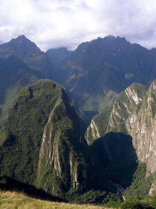
Putukusi and the rugged peaks surrounding it seen from Machu Picchu
The mountain, like all others in the area, is composed of near vertical, perfectly smooth stone walls with steep gullies intersecting them. The entirety of them are covered in jungle and cloud forest so dense so as to render off trail hiking completely impossible.
The trail leading up the mountain is more vertical than it is horizontal and that seems to be the general pattern among mountains here. When looking out at Machu Picchu from the summit of Putukusi it is interesting to think why the Incas chose to build their empire in such a rugged place. Surely the incredible beauty of the landscape inspired them, and they thought of themselves as standing in the presence of their gods. The wilderness here is some of the most pristine left anywhere on earth, and much of it has most likely never seen a human being. It is interesting to imagine that there might be other "Macchu Picchus" hidden out in these mountains that nobody knows the existence of.
Getting There

Peru Rail in the Urubamba valley
The simplest method is to catch the train (Peru Rail) directly out of Cuzco. You should plan about (4) hours total for the train ride. If you chose the train out of Cuzco, be sure to purchase your ticket in advance. Even on a visit during the off season, can get sold out.
There are several classes of service available. The cheapest one is known as the Backpacker train. In 2008, a roundtrip ticket was $96 US. The only complaint regarding the Backpacker train was that there is no leg room available. The mid priced train, known as the Vistadome, is much nicer, has more room and on the way to back even has an on board fashion show featuring local fabrics. The fare for the Vistadome train was $142 US for a roundtrip ticket. The most expensive train looked to be pretty luxurious. Apparently it's a $500 US roundtrip, but that is second hand information only.
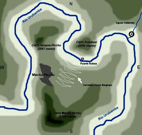
Map of the area
The other option is to take a bus from Terminal Terreste (the bus station in downtown Cuzco) directly to the town of Ollantaytambo, and hop on the train to Aquas Caliente from there.
The train will drop you off at the train station in Aquas Caliente, which is at the opposite side of the town . If you were to immediately climb Putukusi, all you would have to do is walk to the other side, where the railroad tracks (continuing in the same direction) leave town. Over the years, the town has grown, so you can't follow the tracks anymore but have to go through the town center instead.
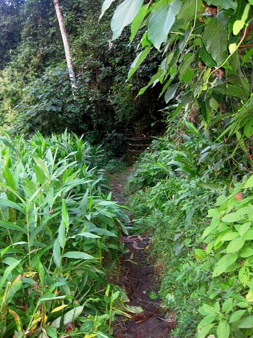
The somewhat overgrown trailhead
Once you're on the trail, it's impossible to get lost. The trail basically goes straight up the side of a steep mountain. Count on an hour and a half to get to the top.
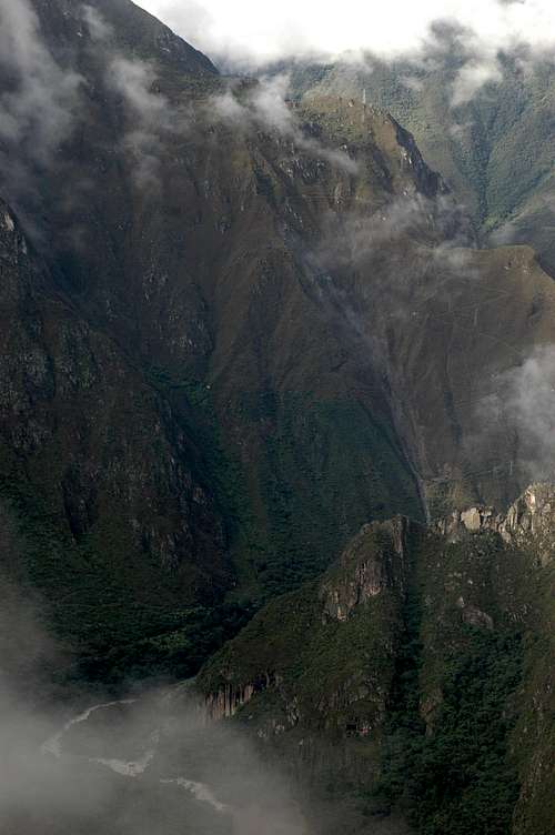
Shards of fog rising uip from the Urubamba valley
Red Tape
No red tape or permits required. Climb whenever you want, and respect the stunning wilderness that surrounds you.Accommodation
There are plenty of places to stay in Aguas Calientes, at all price ranges, and there is a small camp ground on the banks of the Urubamba river, just outside Aguas Calientes, past the Putucusi trailhead.There are also plenty of hotels around town as well.And for those with money there is the lodge at Machu Picchu for those with the money. The cheapest room starts at $795 US per night (2008), and tops out for a suite at $1,320 US per night. Here is a link for those that care to check it out:
Machu Picchu Lodge
Weather Link
Current Weather ForecastLinks
| Peru Rail | Lots of good information on this link to get yourself familiar with the train service. |
| Putucusi | Information from Wikipedia on Putucusi. |
| Machu Picchu | More good information from Wikipedia on Machu Picchu. |
rgg - Mar 11, 2012 1:52 pm - Hasn't voted
Many broken ladders in 2011When I visited, in June 2011, I learned that the rainy season had seriously damaged the ladders, and some were gone completely. Alongside the longest ladder section, a thick steel cable was hanging down - perhaps as aid for workers on the trail? For most hikers, that would be the end, but I scrambled up anyway, using the remains of the ladders and the steel cable. Above that section, there were no more serious problems to the top.