
|
|
Mountain/Rock |
|---|---|
|
|
34.50160°N / 112.5°W |
|
|
Yavapai |
|
|
Hiking |
|
|
Spring, Summer, Fall, Winter |
|
|
6440 ft / 1963 m |
|
|
Overview
Quartz Mountain is an unofficial summit west of the White Spar Campground in the Prescott National Forest. Quartz Mountain is not a prominent peak on its own and has higher neighbors including Wolverton Mountain 6,704’ and Mount Francis 7,110’. It has a prominence of approximately 150’.
So, why should Quartz Mountain get its own page? The reason is because it is an ideal destination. It is easy to reach and makes for an excellent hike. From the summit, there are tremendous views in all directions. Meanwhile, Wolverton Mountain doesn’t have a trail all the way to the summit, and summit views aren’t particularly special. In fact, it has less prominence than Quartz Mountain. Mount Francis has a prominence of 490’ but requires a lot of travel on dirt roads and even its views aren’t as good as Quartz Mountain.
Despite its lack of prominence, Quartz Mountain has everything you can ask for in a summit. There’s a trailhead off a major state highway, just south of a major Arizona town. There’s a trail all the way up, it’s easy to follow, there is a great view from the summit; and there are giant quartz rocks on top.
The actual elevation isn’t marked on topographic maps. Google Earth™ shows 6,440’ at the highest point, and that is what I am using, although that isn’t necessarily the right number; it is in that vicinity.
There is an option to include Wolverton Mountain as well as Mount Francis in the same day as Quartz Mountain.
Quartz Mountain is best hiked between March and May, and between September and November. Summer heat and fire danger are deterrents in summer months. Winter hiking can easily be done, however, that is dependent on snow conditions. You’ll have a lot less company in colder weather months, but also far colder temperatures than the Phoenix metro area.
The only downside to Quartz Mountain is traffic from mountain bikes that share the popular 9415 road and area trails. Just watch out for these cyclists so they don’t catch you by surprise.
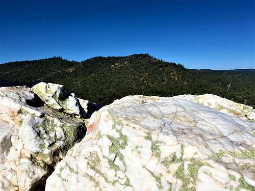 View from the summit of Quartz Mountain
Getting There
There are three primary starting points. The first is the Quartz Mountain Trailhead of Highway 89. The second is the White Spar Campground and the third is at the Wolverton Trailhead tucked into a neighborhood in the forest southwest of Prescott.
If coming from I-17 from the Phoenix metro area, both access points are reached by taking Highway 69 all the way to Prescott. Once in Prescott, get on Highway 89 south to the entrance to the White Spar Campground. Type “White Spar Campground” into your GPS and it will get you right to the Campground. Park in the day parking area.
To reach the Wolverton Trailhead, you take Highway 89 south to Copper Basin Road. Head west on Copper Basin for 2.3 miles and go south on Sheriff’s Posse Trail. There is a small dirt pullout where you can access the trail. The address for GPS is Wolverton Trail, Prescott, Arizona 86303.
Route
From Quartz Mountain Trailhead, head west for 3/4 miles and then take a left on the road winding around Quartz Mountain for a third of a mile to the west side. Then head up. It's only about 1 1/4 miles to the summit, gaining 660'. From there, you can hike onto Wolverton Mountain or Mount Francis.
From White Spar Campground, cross Highway 89 and the trail is right there. Take the windy trail for about 1 ¼ miles until reaching the 9415 road. You can actually cross the road stay on the trail, but the trail adds an extra mile of distance. If staying on the road, continue until you reach the base of Quartz Mountain. A road on the right goes to the west side of Quartz Mountain. One you reach the west side, you are 2 ½ miles from the trailhead. It’s less than a quarter mile further and about 150’ to the summit of Quartz Mountain. It’s pretty steep. The summit is on the far side of the mountain, so continue along the summit area to the eastern edge.
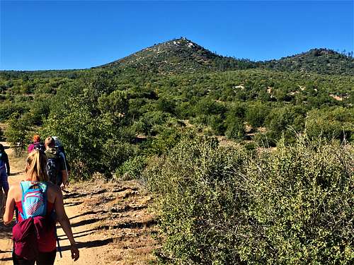 Approaching Quartz Mountain from the east
From the Wolverton Trailhead, take a left and follow for about a mile to the 9415 Road. At this point, you are just below Quartz Mountain, which rises to the west. Two roads go around either side of Quartz Mountain to the saddle. Once at the saddle, head up the steep slope to the summit.
If taking the road on the left it is about 1.75 miles to the summit; and if taking the road to the right, it is closer to 1.5 miles. In both cases, the elevation gain is only about 600’. Alternatively, you can take a right at the Trailhead and hike up Wolverton Mountain first. It is about a 4.5 mile loop if including the long way around Quartz Mountain.
Once atop Quartz Mountain, there are large Quartz rocks and great views. However, the true summit is on the east side of the summit area, up some additional quartz rocks.
Red Tape
There is no red tape in particular. Park at the dirt day use parking at White Spar Campground, which is a quick right turn past the entrance. Check fire conditions and any road closures before taking these routes, especially between May and October. Watch out for mountain bikers.
External Links
https://www.alltrails.com/trail/us/arizona/wolverton-quartz-loop