
|
|
Mountain/Rock |
|---|---|
|
|
38.12227°N / 115.70857°W |
|
|
Nye |
|
|
Hiking |
|
|
Spring, Summer, Fall, Winter |
|
|
10185 ft / 3104 m |
|
|
Overview
The Quinn Canyon Range sits in central Nevada near U.S. hwy 6 and state hwy’s 375 (the “Extraterrestrial Hwy”) and 318. According to the USFS site –“Extreme isolation defines Quinn Canyon, a remote central Nevada wilderness. From the main ridgeline of the area, cresting at more than 10,000 feet, many smaller ridges and narrow canyons extend out east and west. In the Vshaped drainages, snowmelt along with summer rains collect in four year-round streams. Several springs usually provide water. From pinyon pine and juniper, the vegetation gives way to sagebrush with scattered white fir, aspen, and mahogany higher up. Small stands of bristlecone pine can be found here, too. Mule deer move into the higher elevations in summer.”
It is a beautiful area, and the getting there is just as scenic. It was a little hot for my tastes for a mountain hike here in early June, but it was tolerable. According to weather.com June thru September averages are the low to high 90’s for Alamo, NV, located further south on US 93 and at 3500 feet in elevation. The Quinn Canyon Range rises from ~6,500 – 10,000 feet in elevation, while the high point at 10,185' has 2,587' feet of prominence. The range high point overlooks the North Fork of Cottonwood Creek, which has flowing water year round according to the Forest Service.
The Quinn Canyon Range highpoint itself looks to be on the very border of the southern portion of the Quinn Canyon Wilderness, and this route description is of access from Humboldt-Toiyabe National Forest.
Getting There
I suggest looking at a Gazetteer Atlas, or a Nevada Road and Recreation Atlas (which was my source). Wherever you come from, the Davis Ranch at the head of the North Fork Cottonwood Creek road is your destination. The ranch is private property, drive past and there is assorted nice camping creek side w/in a few hundred yards, though only a couple cars can be accomodated. The road continues on, suitable for ATV traffic. The dirt roads once on the Cottonwood Creek road got a little confusing. I believe I always veered left at forks, continuing up canyon always. I never took a 90 degree turn and wound up at my destination ok. Maybe some luck ? I had no problem at all getting here in my passenger car. The roads are good and graded, and dusty. Although I'd be MUCH more cautious if they got rained on good.Route

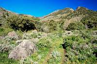
From camp, lace up and continue up the atv track. In a few hundred yards it will fork, bear left, then you follow this 2 track upstream thru exceptionally beautiful sage brush flats w/ sparse pinyon/juniper forest for the first few miles, all the way to the head of the North Fork Cottonwood Creek.


There will be a few stream crossings, expect to get wet or get creative if water is high. And careful, those rocks are very slippery. Beyond this my suckometer really spiked due to the off trail bushwhacking required to gain the ridge.


Once on the crest though it is much easier going. When the 2 track ends pick your poison and head up towards the peak as you see fit. My online topo resource shows trail continuing all the way to the ridge just west of the high point, but I did not see that. Maybe I lost it ? At any rate the 2 track continued up the left fork of North Fork Cottonwood Creek for a little bit until it stopped, then I beat a path up to point10.089, then traversed over to the range high point at 10.185. Relax and let the “ooh’s” and “ahh’s” fly.
My route of egress I chose to traverse over to point 9651, then follow the ridge down to the car as needed. This afforded me a clear view of the Davis Ranch where I was camped a few hundred yards above, but was bushwhacky in many places, and again my suckometer spiked. Good luck.

Camping
I camped just above Davis Ranch in a stand of trees creek side. It was fantastic. There is private property around the area, if you pitch a tent make sure you are not trespassing. The Sand Spring Valley or Garden Valley should have many opportunities for primitive camping as well.External Links
USDA FSRed Tape
Humboldt-ToiyabeThe Quinn Canyon Range highpoint itself looks to be on the very border of the southern portion of the Quinn Canyon Wilderness, and this route description is of access from Humboldt-Toiyabe National Forest.
Dean - Jun 8, 2010 11:01 pm - Voted 10/10
Some additional stuffThis one comes in at #94 on the top 100 Nevada prominence list More here.
goofball - Jun 8, 2010 11:52 pm - Hasn't voted
Re: Some additional stuffThanks Dean.
greatbasinmarmots - Jun 9, 2014 9:16 am - Hasn't voted
Little Cherry Cr "trail"The Little Cherry Creek backcountry is indeed true wilderness in the roadless sense; and there is some amazing geology and ecologically important riparian areas; but the truth is that the area is overrun by cattle and choked with impenetrable thickets of fire-suppressed mountain mahogany. The USFS has cavalierly abandoned any attempt to make the trailhead area appealing to even hard-core wilderness hikers. Most signs have been removed, and the trail register has been blasted with a shotgun. Some of the entries in the bullet-riddled trail register are disconcerting to say the least. I could not help but wonder if my vehicle would be vandalized while we were in the backcountry. The area has effectively been handed over to the local ranchers who treat it as an extension of their private land. The area needs controlled burns and more frequent visits by the USFS.